

NEOH
-
Posts
3,189 -
Joined
-
Last visited
Content Type
Profiles
Blogs
Forums
American Weather
Media Demo
Store
Gallery
Posts posted by NEOH
-
-
Sounds right. Yep very difficult to measure. Maybe this last band will push us to 4"
We should hit 4" easily. Dumping snow right now. Looks like the band stalled around 422, and will probably push north as winds veer WSW. The snow won't last long though.
-
Picked up 3.7" last night... that was the best measurement I could come up with. Beat my expectations. Last band is pushing through now. Nice flake size.
-
I'm pretty sure those maps come straight from their grids added up, but not 100% sure. There may be a little bit of human input on the map itself (obviously their grids have human input).
I didn't want to post that map this morning because I really don't agree with it. It's a good LES setup for SW NY south of Buffalo and that could come into Ashtabula and Erie at times, maybe Lake County can get grazed and get a couple inches of LES on top of the clipper. But with a mainly WSW flow and ice cover expanding on the lake I'm not very optimisitc for NE Ohio on this one.
The clipper tonight could cause a mess due to temps only in the 10-15 degree range, more high ratio snows and gusty winds...with wind chills probably falling below -10F again tomorrow at some point. A lot of kids may get another day off tomorrow.
Thanks. By the look of the map, you would think the lake is ice free with a WNW fecth. The flow will be WSW as you mentioned, around 260. At least we have the clipper snows... 2-3" seems possible.
-
Anyone know how CLE's snowfall map is generated? Another over done map.

-
Had just under an inch of new snow from yesterday evening to this morning.
Looks like Cle is combining the clipper and a little lake effect into a lake effect advisory for 4-8". I'd be thrilled with the bottom total lol.
Same total here. Not sure why CLE is so bullish on LE. Looks like 2-4" from the clipper... but I wouldn't count on much, if any LES. Winds don't come around WNW'erly behind the clipper... although the GFS is close for short time before shifting to the WSW. Would be nice to notch a 4" event considering yesterday's bust.
Next weeks overrunning potential looks good as well. Should stay all snow in Northern Ohio. Nice to have a couple of things to look forward to after yesterday.
-
CLE has waved the white towel on this event understandably. I'd say on to the next but I think this was the last shot at a significant LES event. Ice cover will really increase the next couple of days which will put a cap on the moisture. You can see slush forming on the crib webcam.
Maybe we'll see another inch or two as the weak bands swing back north.
-
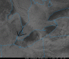
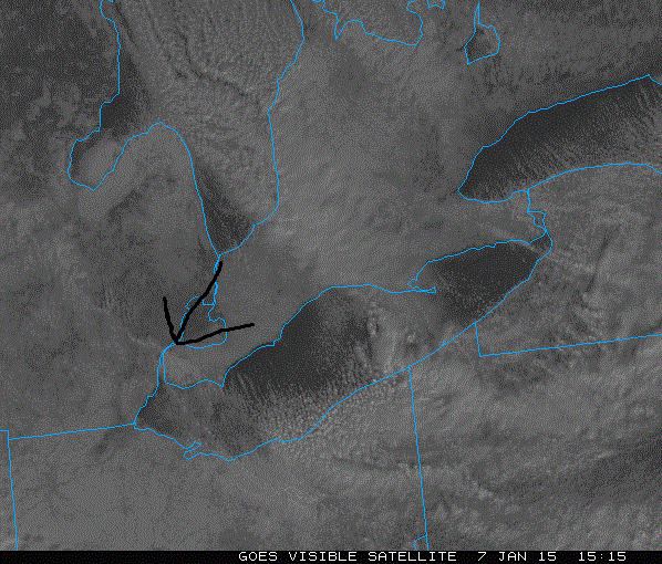
Have we ever had a Huron connection from due north that set up on the east side?
It's very rare, but happens on occasion. My poorly drawn arrow was pointing at the band originating from lake michigan. That huron band won't be moving too far past the OH state line. Seems to wiggling eastward actually.
-
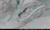
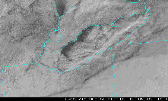
Nice view of the band that pushed through earlier... it definitely had a connection to lake MI. Winds are coming around more northerly and the connection is backing to the west. Lots of dry air out there with clear skies in the northern side of the lake.
-
Pretty good snow under this band despite fairly light returns. Unfortunately it's moving. We'll see if a consistent light to at times moderate snow can at least set up in the orographic lift areas inland and allow it to stay wintry looking today, even if amounts end up being light.
We've had a few good bursts in Chagrin. Flake size was ok as well. The bands are migrating instead of staying in one place. To see the higher totals we'll need a band to lock on place. Considering the fetch I don't think that ice is the limiting factor. Once the fetch turns more westerly I do think the ice will play more of a role.
-
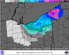
A band is trying to take shape over the lake. If you look at the infrared satellite there is a connection upstream to lake michigan. Here's the latest CLE snowfall map through 1am tonight. Definitely seems high outside of where the lake huron band sets up.
-
Bit surprised and disappointed, only another .6" fell as band quickly fell apart after 4am, so 6.6" overnight. Now have received 13.4" since Sunday night. We shall see what today brings, really not feeling it with the partly cloudy skies out there. Wonder if this will verify, seems a tad robust:
Congrats on the snow last night. You may be in the jackpot area today if the lake huron band sets-up over you... which is possible. Post a pic as the band comes through... I'm sure snowfall rates will be insane.
-
I came up with 3 -3.5" in several spots. Seems high...I'm wondering if there's some blown snow mixed in.
Not sure how far east of me you are... but wouldn't be surprised if you picked up a little more as the radar showed the heavier returns just to the east. I'm just west of snyder rd. off of bell.
-
Picked up 2.5" last night. Must have fallen pretty quickly. We'll see what today brings... not feeling really good but hopefully the radar will improve. The lake huron band will be incredible.
-
I'm confident in a decent band into Lake/Ashtabula into NW PA tonight dropping 4-8" type amounts, with a nice squall dropping 2-4" on a short period as the front causes that band to pivot south during the early morning tomorrow. After that though I'm definitely worried about a period of very disorganized snow in the Cleveland metro before an increase in the evening. I think the band tonight into early tomorrow will be intense enough to get a lot of areas close to my low end totals, with any bands that can redevelop during the evening adding to that.
The ARW is stingy and shows .1-.2" of liquid across the metro and a little more in parts of the Snowbelt... The NMM looks like a decent quarter to half inch in the traditional Snowbelt with close to 0.75" in Lake County. So we'll see how it plays out
Les is looking good upstream. Nice sign. The band is intensifying over Lake Erie as well. Should be an interesting morning. The CLe discussion basically mirrored your thoughts for tomorrow.
-
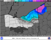
This snowfall map from CLE is a lot more realistic in terms of the heaviest snowfall placement.
-
I'm starting to feel a little less optimistic after seeing the ice cover. Not sure how much ice will be added tonight, but any additional coverage into the central basin will really affect the moisture flux. We need winds and waves to pick up asap. 6"+ would be a win around here.
-
A lot of ice managed to form on the lake last night. Very impressive considering it was ice free just 2 days ago. The western basin is closed for business, and slush is pushing into the central basin. Not sure how much this will affect tonight/tomorrow as the flow is primarily out of the NW. The ice will certainly limit heat/moisture flux. Hopefully the winds can push the slush around in the western part of the central basin. But I would count on much snowfall from Lorain west as the winds will be mostly moving over ice.
-
Had about an inch, as expected. CLE had 0.09" inches liquid equivalent on the metar, but climate report shows only 0.04". That seems to happen quite a bit. Very odd to see the metar totals reduced in snow events, normally they under report and need to be beefed up.
CLE is being too aggressive with snow totals tomorrow in my opinion, particularly for lake shore areas. I'll be shocked if more than 3" falls near the lake from downtown and points west.
But as always with lake effect, anything can happen.
Trent - One positive for the immediate lakeshore is that there is already an established band over the lake.... which should further strengthen. That should be good for a few inches as it sags south, possibly more as troughs always take their time moving through. But yeah, once the strong NW winds set-up the heavier snows will move inland. We'll probably see the "green blob" until the drier air moves in.
-
Picked around 1.4" last night.
Great analysis OHWeather. It will be interesting to see how everything works out. As you mentioned, dry arctic air is never a good thing for seeing significant totals. Seems that you can get away with lackluster parameters when lake temps are warmer, but now that the lake has cooled, everything needs to come together perfectly to see high totals.
Looking at the bufkit text output, both the GFS and NAM have winds coming around to 320 for about 9-12 hours starting tomorrow. The 320 fetch provides about 54 miles of open water in NE OH... less than optimal for heavy snows.
With lake effect there are always some surprises so we'll see what happens. CLE seems to have exanded snowfall totals in their latest map. I'd be disappointed and surprised not to see 8"-10" IMBY.

-
Looks like the snow hits an impenetrable wall right at the edge of CLE and PBZ's CWAs.
It has been in the works for years... Nearing completion as per the map.
-
Just noticed CLE's updated snowfall map. Pretty hefty totals by Wednesday evening.

-
Reducing my call from the clipper to 1-2" at most. We will have to rely on the lake for our snows. I overly obsess about ice cover... but I hope the ice doesn't ruin the LES event on Wednesday.
-
There wasn't any ice on that camera yesterday morning, too bad it's already icing again. The winds will shift around with the clipper going by, so hopefully that keeps the ice from forming solid until at least Wednesday night.
The good news is that we won't have a calm night... otherwise there would be a solid freeze up. Drove past a small lake today and noticed there was no ice... yet a large body of water had no problem developing ice quickly. The flow on Wednesday comes around to 320-310 it appears which takes most of the western basin out of play anyways. I'm sure there will be significant ice coverage from the islands back west.
Looks like snow with the clipper will be limited to 2-3" at the best.
-
Ya we look to be on the southern edge right now. Hopefully we can hang on.
I'm surprised cuy isn't under an advisory.
The wed- Thurs event looks interesting. Hopefully we can hold off or minimize any ice forming ...
Yeah, not sure why NE Cuyahoga is left out... CLE seems to be doing that lately.
I'm pretty sure the western basin will be mostly iced over by Wednesday considering the cold temps. Lots of ice out west by Toledo...


Northern Ohio Obs/Discussion Part 2
in Lakes/Ohio Valley
Posted
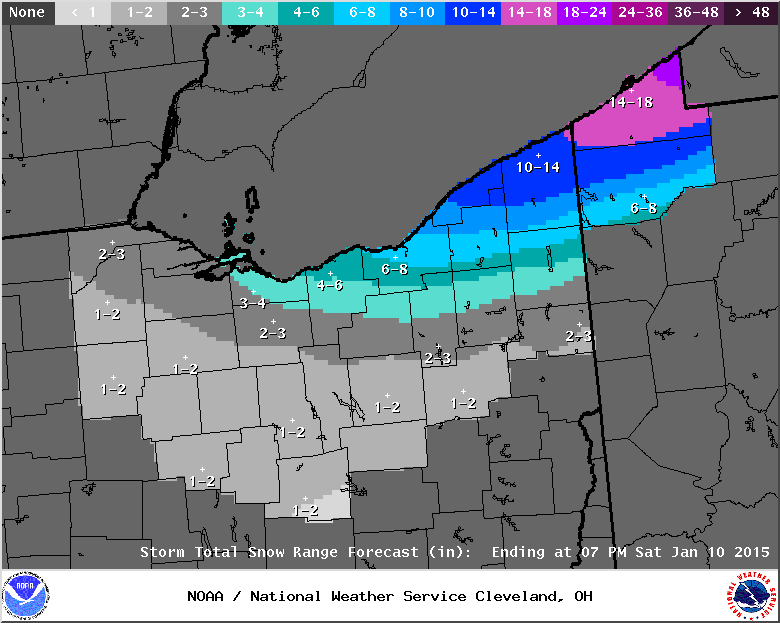
CLE extended the LES advisory until 4pm Saturday. Not sure why Geauga would be included, at least the entire county as there isn't one model that brings the snow inland. Strange.
NEAR TERM /UNTIL 6 AM SATURDAY MORNING/...
COLDER AIR FILTERING INTO THE REGION WILL CONTINUE INTO THIS EVENING WHICH WILL DESTABILIZE CONDITIONS OVER THE LAKE...SUPPORTING INCREASE LAKE EFFECT DEVELOPMENT. THERE IS THE POTENTIAL FOR SOME ISOLATED THUNDER BUT BEST CHANCES EAST OF OUR AREA. THE WSW FLOW WILL KEEP ASHTABULA AND ERIE PA COUNTIES UNDER THE BULLSEYE FOR SNOW MOST OF THE NIGHT...WITH THE BEST CAPE AROUND 06Z. COULD SEE HIGHER SNOWFALL RATES AROUND 2"/HR BRIEFLY DURING THIS TIME FRAME. HAVE ADDED ASHTABULA TO THE LAKE EFFECT SNOW WARNING. LOOKING AT AN ADDITIONAL 3-6" IN THE ADVISORY AND 6-12 IN THE WARNING.