

NEOH
-
Posts
3,279 -
Joined
-
Last visited
Content Type
Profiles
Blogs
Forums
American Weather
Media Demo
Store
Gallery
Posts posted by NEOH
-
-
Lots of tree damage locally from the storms last night. Must have been a downburst. Power is out in many places in Chagrin, South Russell and Bainbridge. Closing in on 9" of rain for the month... current total is 8.67".
-
Already up to 5.5" of rain for the month. Quite a few power outages around after the line came through last night. Surprised CLE only reported .35" of rain yesterday... must have been missed by almost every storm.
-
Finally starting to feel like Summer today. May was just an awful month around here... cool temps with nearly 6" of rain. CLE finished May -3.3 with 5.30" of rain.
-
Brutal to wake up to snow on the ground this morning. Looks like we are stuck in this pattern for awhile.
-
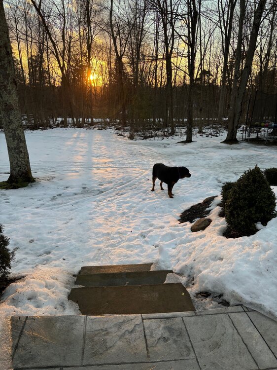
Picked up 1.2” last night. Hopefully that’s the last of it for the season. Looks scenic out there but I’m ready for Spring.
-
Really enjoying the longer sunsets. The remaining snowpack should be mostly gone by Friday. Nearly 2 full months of snow cover imby.
-
 1
1
-
-
10 minutes ago, dta1984 said:
Same, it's been a good (not great) winter and we were due after the past few clunkers. Bring on an early spring.
This year might be the longest we've had snow cover since I moved out to Geauga county. Despite snowfall being around average, we managed to avoid the big warm-ups and/or heavy rains.
-
The snowpack has taken a beating the past few days. Still solid cover IMBY but some patches of grass showing up in exposed areas. At this point I'm looking forward to warmer weather. It was a great Winter for snow on the ground.
-
1
-
-
On 2/18/2025 at 11:44 PM, OHweather said:
Sort of an interesting snow event Thursday into Friday with a slow-moving low-level trough axis bringing light synoptic snow showers, with lake enhancement south-southeast of the flake. Should be a general light accumulation, with several fluffy inches in the higher terrain of the snowbelt.
Picked up an inch last night/this morning. 2-4" in the forecast today.
-
Great day yesterday. Picked somewhere around 7 - 8"... hard to tell with the strong winds blowing everything around. The storm was much better than expected.
-
Rain just flipped to ice and snow here. The temp didn’t get above 36 last night… still some snow remaining from part 1. Radar looks good to the west.
-
1 hour ago, vpbob21 said:
First part was a dud here. Got less than half an inch. Hopefully the second part tomorrow delivers for us.
Recent model runs keep the low a little further southeast of here. Your area might flip to snow fairly quickly tomorrow morning. A low near PIT is usually a good track for northern Ohio.
-
2
-
-
1 hour ago, dta1984 said:
It's been a very scenic morning, right at 2" before it switched over to drizzle. Good start, hopefully tomorrow delivers as well.
A little over 2” here. Temp is up to 34 now. Hopefully there is good thump tomorrow. 12z models have decent snow across northern Ohio.
-
It has been snowing nicely since 7am... huge cotton ball flakes. Enjoying it before the changeover later this morning.
-
1
-
-
11 hours ago, OHweather said:
Interesting pattern. Maybe some snow squalls Thursday evening on the leading edge of the stronger cold air advection. Models have ticked NW for the weekend storm, but it still looks like an interesting system. Should be some front end snow late Friday night into Saturday, a period of rain Saturday afternoon into Saturday night, changing to at least light synoptic snow late Saturday night and Sunday as the low pulls away. The lake is mainly frozen but there should be some enhancement Sunday through Monday with north winds gradually shifting more westerly. It will be windy Sunday into Monday so any snow accumulations will blow around on the backside of the storm.
Not sure what to expect this weekend. Typically a low near the panhandle of WV / or just north is a pretty good spot for snow in northern Ohio. Hopefully we'll see a SE trend today. Still have a solid snow/ice pack although there are patches of grass. It just refuses to melt at this point.
-
Looks like the low will pass near CLE tomorrow with rain unfortunately. The weekend looks interesting. Let's revisit today's 12z gfs and cmc runs on Sunday.

.png.28f3726370dc0dddcd4131948eca806f.png)
-
Everything is caked in ice this morning. Looks pretty with fog rolling in.

-
2
-
-
12 hours ago, RogueWaves said:
Mistake by the lake. Even in the snow dept. Feel bad for any winter enthusiasts living there.
Snowfall has been bad around Northern Ohio the past few years. Its all relative though... 50" of snow in the snowbelt just east of Cleveland is considered a bad Winter. There are areas east of Cleveland that have likely had 90"+ already this Winter so the airport location is not a great representation of the entire area. 34 straight days of snowcover imby this year so no complaints compared to the past two winters.
-
 1
1
-
-
12 hours ago, dta1984 said:
Picked up 1.5" of snow this afternoon. Drizzling right now. Wonder if we'll get some thawing of the lake ice with the slightly warmer temps this week?
Nice surprise yesterday... very scenic wet snow. Still a decent snow pack remaining around here, but today's warm temps should melt quite a bit. There should be enough thawing on the lake to at least provide some moisture to work with.

-
There is a solid 3-5" of glacier snow left imby. It has been a long time since we've had snow on the ground for an entire month. Definitely a good January. The sun is now over 30 degrees at mid-day (same sun angle as early November) and you can really feel the difference. Not feeling great about a gradient pattern as the cold side tends to set-up to our NW, but we'll see how February plays out.
-
Picked up 2.2" last night/this morning. Still some moisture coming off of the lake I guess.
-
1
-
-
10 hours ago, OHweather said:
Nice overperforming, fluffy lake effect event. I'm nearing 6"!
That was a nice finale to the LES season. Picked up 5.5" IMBY. Good to have fresh powder on top of the old snow.
-
1
-
-
1 hour ago, dta1984 said:
33 and snow this morning. Wondering if it will stay snow or if we will flip to rain this morning? It's actually starting to stick to pavement again.
Interesting quote from CLE regarding tomorrow - Sun night
"The Sunday forecast is a bit sneaky with the snow potential across Northeast Ohio, especially near/east of Cleveland. After aa lull in snow tonight, a system developing southeast of ther egion will allow for some synoptic moisture to try and creep back into the forecast area and bring some light snow to the eastern half of the forecast area. Then, a favorable lake effect snow setup will start to emerge Sunday afternoon with NNW flow across Lakes Huron and Erie. This should allow for lake effect snow to push into Northeast Ohio with a couple inches of snowj ust east of the Cleveland metro given the favorable fetch. This wvent will be limited by the lack of deep moisture across the region. However, the sfc-5000 ft layer over the lake will be very unstable with good low level lift, so this has the potential to uptick as a sneaky shallow lake effect event before this events starts to pivot east, as mentioned in the short term" period below."
I woke up around 6 and it was drizzling… around 8 it flipped to snow and has been light to moderate since. According to the models we will likely stay all snow. There has been a lot of compaction since yesterday which will turn into a glacier.
-
Finally a good view of the lake today. Surprised to see so much open water. Feels like Spring out there with sun and temps in the mid-30's.

-
1
-


Northern Ohio Obs/Discussion Part 2
in Lakes/Ohio Valley
Posted
I finished June with 10.81" of rain. Still too wet to cut portions of the yard. Looks like CLE only had half of that amount. Most of the storms just missed CLE to the South and East.