

NEOH
-
Posts
3,189 -
Joined
-
Last visited
Content Type
Profiles
Blogs
Forums
American Weather
Media Demo
Store
Gallery
Posts posted by NEOH
-
-
21 hours ago, OHweather said:
In spite of the ice, I’m probably more optimistic about the next 4 days regarding snow locally than I’ve been about any 4 day stretch so far this winter. Which isn’t saying too much

Ha. Just read the AFD you wrote... hopefully this event works out.
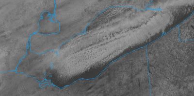
Confidence is increasing in at least a light snow area-wide late Thursday night into Friday following by lake effect snow later
Friday into the weekend. There is some potential for a more notable synoptic snow if the more amplified solution with Friday`s system
proves correct, though that widespread snowier outcome is still on the "less likely" side. Regardless, the set-up looks favorable for
notable lake enhanced/effect snow Friday into Friday night from the Cleveland metro area into both the primary and secondary snowbelt
with a north-northwest flow. While growing ice in the western and perhaps central basins may be a small negative, there should still
be enough open water for a robust lake response. Ice needs to be thick and locked in to really limit that.
-
 1
1
-
-
It didn't take long... ice covered western basin already. Will be interesting to see how much ice spreads across the central basin over the next couple of days. Just last week water temps were in the still in the upper 30's and now ice cover. We will probably get a favorable LES set-up now that ice cover is on the lake
-
55 minutes ago, WHEATCENT said:
and at least a week of temps 0-10 at night and 20 or below during the day
Brutal stretch for sure. You might get some lake effect up near the lakeshore... or at least a good view of the bands offshore
")
-
On 1/9/2024 at 5:36 PM, LakeEffectOH said:
Since the lake is a "warm" 40 deg., It's possible we get a lot of LEH & LES snow, starting late Friday and lasting for several days due to the Arctic air settling in for at least the next week. Most guidance has consistently shown potentially heavy snow totals for a few days now. Fingers crossed!
Really couldn't draw it up any worse... low cutting northwest of us with limit wrap around snow... then a WSW'erly wind direction taking the lake effect to western new york. Not a great start to the year weather wise.
-
51 minutes ago, WHEATCENT said:
It'd be nice to maybe get some lake effect at least if we're gonna get all these 43 degree rainers while everyone else from New England to Arkansas to Chicago cash in
Yeah, we've been bleeding "warmth" from the lake with very little to show for it. Lake temps are still around 40 or so.
-
Snow cover has taken a beating today and should be gone by the end of the day. It will be interesting to see if the models respond/change for the weekend storm once this one passes. Would be great to see an Ohio river track to PIT.
-
Woke up to 1.5" of snow this morning. Nice surprise.
-
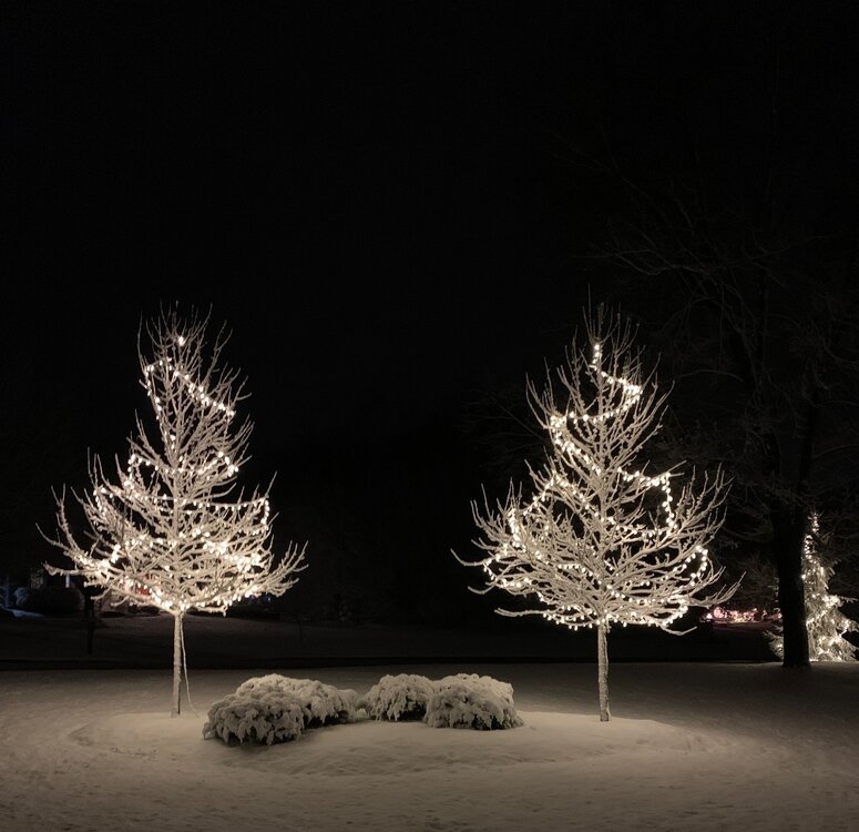
It has been nice to have snow on the ground all week... definitely helped make it more festive. It is melting and the rain tomorrow should finish most of it off. Considering how bad the pattern has been we've been pretty lucky with snowfall.
-
1
-
-
9 minutes ago, LakeEffectOH said:
In Chesterland, I got at least 8". However looking at the storm reports around me, by certified spotters, accums are between 3.5 - 5". I checked pretty well for drifts before...estimating the depth. Strange. Maybe I better get a snow measuring device.
Your area always does well so I don't doubt 8" fell. There was a consistent blob of heavy snow around and just north of 322 yesterday afternoon. The ground was soaked from the rain prior to the snow so definitely some compaction.
-
1
-
-
Just over 6" IMBY. Very picturesque snowfall as the snow was pasted to everything before the strong winds late last night.
-
4
-
-
1 minute ago, OHweather said:
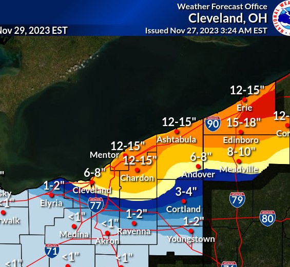
Starting to try to stick here a bit…looks like Chardon already has an inch or two on the webcam. It does look like the Huron connection will be most persistent near or just east of the OH/PA border. The synoptic support and moisture are good for most of tonight, and ratios/accumulation efficiency should get better quickly between 0-3z (should start accumulating better by sunset but ratios may not be great until a bit later when it gets colder). The synoptic support and moisture quickly pull out of NE Ohio 9-12z and out of PA 12-15z, but it’s still a pretty good period where the upslope areas should rack up some fluffy snow. We haven’t seen a NW flow event with favorable moisture and synoptic support like this in a little while. I think inland NW PA will see a general 6-12”, best shot at a foot with the Huron band. I think it’ll be more of a 5-9” type deal in the higher terrain of Geauga/Ashtabula tapering to 3-6” in the hills of the secondary Snowbelt south of Cleveland, with lower amounts in general near the lake. Accumulations will carry well inland but will gradually taper south of the higher terrain. A solid event overall. No major disagreements with the “official” forecast overall.
Everything is covered here in South Russell. Snowing heavily now. The heaviest snow has been just north of here but starting to push south into the area.
-
Nice to wake and up and see this in the forecast. Will be interesting to see where the lake huron band sets up. Looks like the models have taken it more to the east toward the OH/PA border.

-
1
-
-
1 hour ago, TheClimateChanger said:
Temperatures are delivering just fine. With one month left in 2023, it's been 3rd warmest at Toledo, 7th warmest at Cleveland, 10th warmest at Youngstown, and 12th warmest at Mansfield and Canton/Akron. Would be even higher in the ranks if not for a number of recent, even warmer, years at most of these locations.
And these are based on even longer PORs than the snowfall numbers, with 150 years at Toledo and 153 years at Cleveland. That's a predicted exceedance of about once every 75 years at Toledo, and about once every 25- or 26-years at Cleveland. So I would say temperatures are performing VERY well.
Aren't you "Trent" that used to post here? If so, I feel bad for you man. Hope everything is ok with you.
-
3 hours ago, TheClimateChanger said:
Paltry calendar year for snow so far across northern Ohio. A few sites eyeing a record if we get a mild December. Toledo and Cleveland doing a bit better than most with the recent snowfall at those locations, although some of that is simply a result of longer PORs at those sites. While this is the 12th least snowiest calendar year to date in the Cleveland threaded climate record, only three years at CLE airport have seen less snowfall to date (1998, 1946 & 1961).
Due to a lot of missing data and irregularities in the early snowfall data in the MFD and YNG threads, these are based only on years with less than 50 missing days. Wanted to select a target that would allow the most data possible, while excluding clearly erroneous data. Of course, that also means some of the early years may have had more snow than shown - although I believe most of the missing days were days without snow.
Below each box, I've added the existing target to beat for the full 12-month calendar year.
Yeah, the past two seasons have been bad for snowfall. Regression from previous snowy seasons sucks. I guess if temps don't deliver you'll find something else to be negative about. Did you notice that CLE has had BN temp departures 5 of the last 7 months (including Nov)?
-
1
-
 1
1
-
-
15 hours ago, OHweather said:
Ended up with slightly under 3" at home...the snow rates at the office and across the Cleveland area during the commute were nuts. It started snowing at about 6:15am at the office...by the time I got to my car at 7:20 there was damn near 4" on it. The drive home in the middle of all of that and the AM rush was a slow one...a couple of hills that no one was getting up, a few cars off the road and very slow going in between. It was actually a more annoying commute than what I had on December 23 last year (in the middle of the blizzard with brutal cold), though I think that was more a product of more traffic volume this morning. Overall am pretty happy with how the event played out, although northern Erie County PA got way less than forecast. As we move into December, I think it's time for us to get a more widespread snow at some point!
Finished with 5.5" IMBY. Missed out on some of the heavier bursts of snow. Looks like areas around here were in the 6-7" range. Nice start to the season so far.
-
2
-
-
Picked up 4" of snow as the band moved through this morning. All of it came down in the 5am - 7:30 am time frame. Perfect fetch now off of the lake... hopefully add a few more inches today.
-
1
-
-
2 hours ago, OHweather said:
Things still look pretty on track. The flow comes around to a good 290 degrees for several hours Tuesday morning, so I don't doubt snow will get into most of the metro area and probably will at least briefly get down to me (I'm in Macedonia now). I'm not expecting more than a quick couple inches here, though some models have a bit more this far south. Should be a fun commute home from the office in the morning. In the Cuyahoga/Geagua area, there is still some uncertainty regarding exactly how heavy the totals are (though I don't doubt the entire area will get a very intense burst that puts down a few inches early Tuesday, at least). Pretty confident that Lake, northern Geauga, northern/central Ashtabula and most of Erie County will be under banding for several hours tonight before it starts pushing farther inland, so they'll do just fine. The band may end up sinking across Cuyahoga and the rest of Geauga a bit quicker, so for those areas to get higher-end totals closer to 8 or 10" it'll need to snow more Tuesday and Tuesday evening behind the initial band. I do think there's a chance that we end up seeing a more fractured (but still coherent) band sit across parts of Cuyahoga into southern Geauga and maybe even northern Summit/Portage/Trumbull for the rest of Tuesday morning behind the initial burst, as winds end up locking in around 290 for several hours which can focus a band in that area. Instability and snow growth are supportive of heavy snow through a good portion of Tuesday, but the question after the initial burst early in the day is how organized any banding can be. Activity probably does get pretty disorganized for a few hours Tuesday afternoon (some subsidence/shear) but may organize into one final burst Tuesday evening as winds start backing and pushing the activity back up the lakeshore.
Thanks Jim. 290 is a great wind direction as it maximizes the fetch from the western basin. Hoping the band doesn’t drive south too fast. I’m always skeptical of these early season events as winds don’t seem to turn as nw’erly as forecast.
-
1
-
-
16 hours ago, dta1984 said:
Ya looking like Tues is the better day away from the lake. Hoping for the band to slow down as it gets our way.
Looks like the Route 6 corridor on north will be the jackpot zone. Should be fairly intense down this way for a few hours as the band pushes south. Hopefully it moves slowly with a strong land breeze on the south side of the band. Not too confident in the forecasted amounts in this area.
-
1
-
-
12 minutes ago, Speedskater said:
Overnight snow near Lakewood Park. I would guesstimate about 1/4 inch. The temperature, dipped to 32°F at about 2 AM, but at 8 AM it's up to 37°F and much of the snow has melted.
Definitely tough to accumulate near the lakeshore this time of year. Lake temps are still very "warm".
-
Just under 3.5" IMBY. Looks like we missed the heaviest snows but very scenic out there. Typical Fall snowfall with much more on the grass than pavement. The roads were plowed around the city though.

-
5
-
-
First advisory of the season... leaves are about 90% down in this area so tree damage should be limited.
..WINTER WEATHER ADVISORY IN EFFECT FROM 8 PM THIS EVENING TO
10 AM EDT WEDNESDAY...

* WHAT...Lake effect snow expected. Total snow accumulations of
  3 to 4 inches.

* WHERE...Geauga county.

* WHEN...From 8 PM this evening to 10 AM EDT Wednesday.

* ADDITIONAL DETAILS...A cold front moves across the area this
  afternoon, with lake effect precipitation developing this
  evening. Precipitation may briefly begin as a rain/snow mix
  before quickly becoming all snow. The heaviest snow is expected
  between 11 PM and 3 AM when snowfall rates of up to 1"/hr will
  be possible.
-
2 hours ago, LakeEffectOH said:
OHweather, what are your thoughts about the upcoming winter? Hopefully it will be better than last winter.
Last Winter was about as bad as it gets... won't take much to be better
. Really glad most of the leaves came down over the past week if we do get a couple inches of snow tomorrow night.
-
First freeze in the books this week... hit 30.8 Monday morning. And first fantasy snowfall map of the season --

-
2
-
-
Fall foliage is at or just past peak in this area. Seems a week or so later than last year. Rain the next few days should bring a lot of leaf fall as they are turning and falling quickly.

Northern Ohio Obs/Discussion Part 2
in Lakes/Ohio Valley
Posted
Nice to wake up and see this in the forecast, and great to have OHWeather forecasting this event for CLE.