

NEOH
-
Posts
3,190 -
Joined
-
Last visited
Content Type
Profiles
Blogs
Forums
American Weather
Media Demo
Store
Gallery
Posts posted by NEOH
-
-
I'm out of town in southern Ohio at the moment. I'll be back this evening and get a measurement. Looks like a winter wonderland on my webcam though.
Thanks. Yeah, it was pounding early this morning but I'm sure it didn't last long.
-
DTA - How much snow did you get this morning? I left my house at 5:30 and it was coming down with about .5"+ already.
-
Clippers don't tend to trend back north last minute, so I'm not too optimistic for you guys. Of course here it still looks like a rain to light snow shower scenario. The 12z Euro still suggests 2-3" up to Cleveland and 4" for Akron so you'll probably still get snow...but 3-6" amounts will probably set up from like Mansfield to Dover.
Yep, looking good from mfd down to c'bus. The axis is too much NW to SE... A little flatter solution and this area would do better.
-
GFS came onboard with a more southern track for the clipper. Euro has been steady with the southern track. Instead of worrying about mixing issues... we may be looking at a whiff to the south. We'll see what todays model runs show now that the shortwave should be fully sampled.
I'll be in Chicago so at least I won't miss the storm.
-
Foggy with freezing drizzle/mist in Chagrin. Radar looks to be filling back in over the lake
 .
.Edit: Looks like a trough is over the lake. Wondering if it will sink south overnight or just move east. Some pretty nice returns out toward the islands.
-
The snow has tapered off in Chagrin. Just measured 1.5". Damn easterly downslope flow.
-
Just eyeballing it looks like an inch or so in Chagrin. The easterly winds seem to weaking the precip as it pushes north. The snow band is pushing north quickly. Hopefully we can get another inch. I wasn't expecting the snow to be exiting so quickly.
-
CLE is calling for the heaviest snow from Toledo through CLE. 3" seems a bit much but we'll see.
312 PM EST TUE JAN 20 2015
A FAST MOVING AREA OF LOW PRESSURE WILL CROSS THE REGION LATE TONIGHT AND WEDNESDAY. SNOW ASSOCIATED WITH THIS LOW WILL SPREAD INTO THE AREA FROM THE WEST AFTER MIDNIGHT. THE SNOW SHOULD REACH THE I-71 CORRIDOR AROUND DAYBREAK WEDNESDAY. ACCUMULATIONS OF AS MUCH AS INCH COULD OCCUR ALONG THE I-75 CORRIDOR BY DAYBREAK. ANOTHER COUPLE OF INCHES OF SNOW IS EXPECTED DURING THE DAYLIGHT
HOURS WEDNESDAY. RIGHT NOW IT APPEARS THE HEAVIEST SNOW WILL FALL IN A LINE FROM NEAR TOLEDO THROUGH THE CLEVELAND METRO AREA TO NEAR YOUNGSTOWN. UP TO 3 INCHES OF SNOW IS POSSIBLE IN THOSE
AREAS WITH SLIGHTLY LESS AMOUNTS FURTHER NORTH AND SOUTH. THE SNOW WILL BEGIN TO DIMINISH FROM WEST TO EAST LATE WEDNESDAY AND WEDNESDAY EVENING. -
Snowing pretty hard in Chagrin. Radar is filling in to the west as well. If this continues an inch+ would be a lock.
-
Picked up .5" last night. Enough to whiten up the old snow. On to the clipper train this week.
-
Well, looks like the thaw is over. Rain/snow mix most of the morning has transitioned to flurries. Still a nice 3-4 inches out there. I'll take this type of January thaw any day. Only places showing grass are the wind swept areas.
-
Now we have one day in the mid 30's counting as a January thaw next weekend lol
ONE TROUGH AFTER ANOTHER ROTATES SOUTHEAST INTO THE AREA THROUGH THE
PERIOD WITH A TREND TOWARD BROAD UPPER LEVEL RIDGING BY THE WEEKEND.
SURFACE LOW PRESSURE IS PROGGED TO MOVE EAST AND OUT OF THE AREA ON
WEDNESDAY TAKING THE REMAINING PRECIPITATION WITH IT IN THE FORM OF
SOME LIGHT SNOW. OTHERWISE...AS LOW PRESSURE EXITS STAGE
RIGHT...MORE ARCTIC AIR IS POISED TO SLIDE SOUTH INTO THE FORECAST
AREA WEDNESDAY NIGHT THROUGH FRIDAY. THE GLANCING BLOW OF THE ARCTIC
AIR WILL EVENTUALLY START TO SHIFT EAST OF THE REGION INTO MAINE AND
NOVA SCOTIA. HIGH PRESSURE BUILDS EAST AND WE SHOULD START TO SEE
THE EFFECTS OF ANOTHER JANUARY THAW BY THE EARLY PART OF THE WEEKEND
AS WARM AIR ADVECTION TAKES PLACE. BUT WE CANT GET TOO EXCITED AT
THIS POINT AS ANOTHER UPPER LEVEL TROUGH IS EXPECTED TO DIVE INTO
THE AREA BY EARLY NEXT WEEK BRINGING THE WARMER AIR TO AN ABRUPT END.
BUT IN THE MEAN TIME...THE ARCTIC AIR WILL SETTLE IN OVER THE LAKES
AND WE COULD SEE AN OUTSIDE CHANCE FOR SOME RESIDUAL LAKE EFFECT
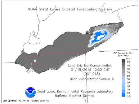
SNOW TO DEVELOP ACROSS THE REGION. LAKE ERIE IS ABOUT THREE FOURTHS
ICE COVERED WITH A HOLE IN THE EASTERN PORTIONS UP BY BUFFALO.
ALTHOUGH...WE CANT RULE OUT THE LAKE MACHINE BECAUSE WE HAVE HAD
EVENTS OF SNOW WITH A COMPLETELY ICE COVERED LAKE DUE TO MOISTURE
FLUX FROM THE ICE ITSELF AND THROUGH THE CRACKS.
WILL DROP TEMPERATURES BACK A FEW DEGREES DUE TO THE COLD AIR
EXPECTED IN THE LONG RANGE.
The Tuesday-Wednesday clipper could be somewhat interesting, but I think it might slide just too far north for you guys. And then we'll was a from there.
The folks at CLE just can't get enough of the warmth.... They should look for jobs in the south. Up to 42/32 Imby. Not a lot of melting with the low DP. The snow is compacting though.
The 12z gfs was a nice hit with the clipper. Looked like the euro brought it right over us though. Great post on the upcoming pattern btw.
-
That's kind of funny. I can't imagine there are many meteorologists that don't find snowfall exciting. It's hard to believe that a degreed meteorologist would prefer 38 and rain over snow in January.
I think 95%+ of this board would find 30s and rain the most miserable kind of weather out there.
Well, its safe to say he's definitely not a winter sports enthusiast
 Afternoon model runs continue the boring pattern. Hopefully we can cash in on the clipper parade.
 -
Interesting disco from CLE. Clearly there are no weenies working there. Unless I'm mistaken, aren't we looking at an 18 hour window or so with temps in the upper 30's? I'm not sure that qualifies as warm spell.
THIS FEATURE WILL BRING WITH IT ANOTHER LOW PRESSURE SYSTEM FOR SUNDAY AND AN ASSOCIATED WARM FRONT SATURDAY NIGHT AND COLD FRONT SUNDAY MORNING. THIS COLD AIR MASS IS EXPECTED TO BE A GLANCING BLOW AS WELL. THE ONE GOOD THING IS THE WARM AIR ADVECTION SATURDAY INTO SATURDAY NIGHT WILL LIKELY KEEP PRECIPITATION MOSTLY IN THE FORM OF RAIN AND WILL HELP MELT OFF SOME OF THIS SNOW PACK WE
HAVE IN PLACE. SO FAR...QPF AMOUNTS ARE EXPECTED TO BE LIGHT AND SHOULD LIMIT ANY THREAT FOR RUNOFF AND RAPID STREAM RISES AND PROBLEMS WITH ICE JAMMING. BUT...AS ALWAYS...WILL KEEP A WATCH ON THE ICE SITUATION THROUGH THE WARM SPELL.
-
The coming winds this weekend should open up some areas again. If the bottom falls out again later next week then it looks like Erie will be out of business by the end of January.
It's pretty much closed for business right now. With such a significant amount of ice concentration it can only push around so much. There will be the usual break up/open area just east of the western basin. Here's the ice concentration... pretty impressive.
-
Visible satellite shows the ice coverage quite nicely this morning, basically Erie, PA and points westward are ice covered.
Just 1 degree shy of a record low this morning, but I did notice many inland locales dipped in the -12 to -20 range under ideal radiational cooling conditions.
Looking at the Great Lakes Snowfall totals thread, there hasn't been a season that has had as much snow up to this point in the past 2 decades that hasn't had at least 50 inches on the season. I think that bodes well, however ice coverage is alarming. How much enhancement can we possibly get with the ice cover extent? With several more cold nights ahead and next week looking cold as well, the ice is probably here through early March.
Last February and March we were fortunate enough to be in an active pattern despite the lack of LES, getting grazed in every direction by storms without a direct hit. Hopefully we'll be as lucky this year, except with a bullseye storm this go around.
Temp was -4 IMBY this morning. Recovered to 16 now, but clouds moved in around noon so that should be it. Yeah, its pretty amazing how quickly the lake iced over considering how mild December was. Any lake enhancement would certainly be limited, although a windy storm would push the ice around.
The warm up is now looking like a one day shot in the upper 30's. We'll have to rely on synoptic snows the rest of the way. I forgot how many times were grazed by storms last winter.
-
CLE at 30.3" for the season is still 4.7" above the average for the date. Looks like a boring week ahead, so that total should fall back to around normal before the next threat approaches.
The lake will be solid by the end of the week, it's a shame we couldn't have cashed in more from lake effect during December and January.
It seems every winter when you leave town we get a decent snowfall
. The thin clouds and flurries made for an awesome sunrise this morning.The next week looks quiet, and seasonable. Yeah, arctic air just doesn't produce big LES totals in this area... too bad the lake will be mostly iced by tomorrow morning.
-
Congrats on the snow up there, it hit a day late lol. There's a Huron band that looks poised to move into Lorain and Cuyahoga Counties in an hour or two, we'll see how much moisture it can pick up off the lake.
I take it you are back at OU. Definitely our best synoptic system of the year. Snow consistency makes a big difference. Yeah, too bad the winds are turning ne'erly....otherwise it's a great set up for a Lake Huron fetch. Huron county might jackpot:)
Go Bucks!
-
Banding has been confined to the lakeshore and over the lake this morning. Might be tough to see another inch around here.
EDIT: Storm total is just under 5". I bet the lakeshore areas have exceeded that as the heaviest bands remained along and north of the coast most of the morning. Snow has moved east so that should do it... unless we see snow showers from the northerly flow.
-
3.5" of new snow. Very wet snow. Still snowing lightly.
Same here. Measured 3.7" a few minutes ago. These heavier snows always seem much more substantial, especially with the powder we've had. Hopefully we can add another inch or so today. Seems doable looking at the radar to the west.
-
Snowing nicely outside... Radar looks great. Temp now 30/24. Everything looks on track.
Edit: down to 28/26. Wonder if the snowfall jackpot might be over Lake Erie.snowing heavily now though.
-
30/12 IMBY. 12z (GFS and Para) seemed to have beefed up snow amounts across N OH. Good to see. Not sure about the euro but think 2-3" may be a little low, perhaps 4".
-
CLE is calling for 2-3", with possible mixing around the 30 corridor. Seems like a decent forecast at this point.
-
Pretty good model agreement on the overrunning snows for Sunday night/Monday. With the strong hp pushing south, I wonder if we don't see a shift south. Should be good for a few inches.
Northern Ohio Obs/Discussion Part 2
in Lakes/Ohio Valley
Posted
Thanks for the snow update. I'm going with your snow totals since I'm out of town. So, you had 1.5" yesterday (evening), and another 2" last night?