

NEOH
-
Posts
3,190 -
Joined
-
Last visited
Content Type
Profiles
Blogs
Forums
American Weather
Media Demo
Store
Gallery
Posts posted by NEOH
-
-
Not a good 0z GFS run for us. 1002 mb low passing over CAK and the 850 mb 0C line going all the way to Toledo. I have my doubts that line would really go that far north given that track, but the north trends are concerning.
The 0z GGEM was a great run for us but it's not the most comforting feeling having to ride the GGEM.
I wouldn't get too caught up in any one model run at this point. I'll give it until Friday before taking anything seriously.
-
I'd say bring the low up to Detroit, drench you guys with rain and southerly winds, and move some ice around

How dare you
 . People will be cooling drinks on Memorial day with the lake ice. Heck, I'm almost ready to sacrifice the snow for some warmth. Must be getting old.
Nice steady light snow falling. Flake size has improved as well.
-
Yeah. Being in a GFS bullseye this far out is never a good sign. Nonetheless it's nice eye candy. However, I like where we sit at this point.
I do wonder if a frozen Lake Erie will have any impact as we get closer? We usually can rely on some slushy areas or large cracks, but after this cold spell and the cold predicted later this week, that's probably off the table. Perhaps if we do get a low that rides close to NE Ohio, like earlier this month, the frozen lake could help keep temps down a bit for the lakeshore areas. It would be extremely painful to watch this cut to our NW after having record cold the week prior and more cold afterwards, but such is winter reality for Ohio.
I just can't see this storm cutting north of this area... Could be very wrong of course. The frozen lake will definitely help. At this point I wouldn't count on any lake enhacement given the ice cover. Not often we get a perfect track but we've done better than usual this winter in terms of synoptic snows. Even if the low tracks to YNG we'd get a nice thump.
-
Totally agree! Not sure that we had a stretch last winter of below 0 temps as what we will have this week...could be wrong though.
Looks like a few chances for light snow the rest of the week, and then another hopefully more substantial system over the weekend.
Neoh, when you get a chance, what's your snowfall so far? Seems like I just crossed 90" recently. Took a few depth measurements yesterday of about 14". Turned out to be a good winter after the horrid December. Imagine if December had at least been normal ..
Seasonal snowfall is at 90.1". Looks like we are almost identical. Haven't been out to measure depth but I'd assume we are close. Yep, some light snows this week with bigger potential over the weekend. I'm almost ready to waive the white flag and say let's get a big one, then move on to a warm/dry March.
-
It's possible you guys break two more records later this week, and it's also possible rural areas get colder than -20 again Friday morning. Incredible
I'd trade record low temps for snowfall amounts any day. This cold is ridiculous.
-
-13 IMBY last night. That two nights in a row in the double digits below zero.
-
HZY got to -23 and even CLE got to -12.
You got yours Saturday, today it's my turn
Enjoy the snow. Good times driving in the hills of Athens.
-
Made it down to -18 last night imby. Brutal stuff.
-
CLE's total is absurd. You would have to think they will revise their total. Right around 7"' here. That band on the southwest side has been parked for a long time. Probably approaching double digits there. ice cover is hurting the east side right now.... Not sure the Huron band will connect to Erie.
-
Since the winds kicked up its hard to measure.... I'll estimate 6-7" so far. Snow has stopped. The Lake Huron connection hasn't come together so we'll see what happens tonight. Not expecting much more but once winds line up from the NNw I'd imagine a decent band will take shape. Not sure how far west it will push. Great storm so far... Brutal outside.
-
Radar has just exploded. Huge fat flakes falling.
Yeah... Quickly flipped to parachutes. This will pile up quickly.
-
Picked up 2" last night. Radar looking good. Snow keeps changing from fine flakes to larger ones.
Nice disco ohweather. Considering we have a couple inches down already your map looks great. Looking forward to the whiteout as the front passes.
-
Just saw that Buf has warnings for 6-12". Wasn't even expecting snow amounts so high, and so close to our area. Precip amounts don't vary that much between wny and northeast Ohio. Clearly not much collaboration between offices. We'll see what happens but if Buf is optimistic I can only think that CLe will be wrong in not issuing advisories.
-
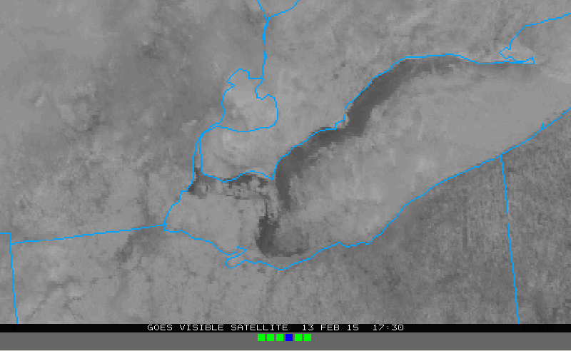
Hopefully we get a good MODIS shot this afternoon as there are just thin high clouds, so the lake should be pretty visible. Would be helpful. With a NW wind with high inversions and RH's behind the front, the lake effect would probably lead to blizzard conditions were the lake more open. As is it could still be fun for a few hours up there...and even down here looks squally with the arctic front.
GOES imagery shows a bigger crack than yesterday, possibly due to the gusty NW winds yesterday, and there could be a little more shifting tonight into tomorrow.
Some high clouds... but you get the picture. The ice has compacted but it's probably maxed out in terms of compaction. Who knows... LES always holds some suprises.

-
Hit 1 degree IMBY. Definitely a bit of lakeshore influence.
I'm hoping tomorrow over performs, snow pack in my area still looks pretty ugly. 2-4" of powder would really freshen things up.
I think officially CLE went down to a trace for a few days in January, but I (and everyone else) has had solid snow over since the beginning of January. We might actually see a 2 month continual stretch with snow on the ground.
Seems like a lock at this point. The crazy thing is that the ground beneath the snow imby is soft. Never froze prior to the snow cover. Hoping tomorrow over delivers. 2-3" seems like a good call.
-
Down to -9 imby last night. I could do without the extreme cold. The weekend isn't looking much better... but at least snow will be falling.
Nice disco ohweather. Looks like a few more inches of fluff on the glacier.
-
Right now it may look like we will be whiffed to the south, but this year, modeled storms have had a tendency to creep NW from where they were originally modeled to go. Lack of blocking may help us out. Depends on how this weekend's New England storm affects subsequent ridging off the East Coast. Don't want Boston stealing our snow. Lol!

Still plenty of time. Not feeling this one with every piece of guidance heading south east. That low to the north amongst other things isn't helping things. Hopefully the lack of blocking will help... We'll have to see how things come together over the weekend.
-
Looks like CLE waved the white towel on next weeks potential --
.LONG TERM /MONDAY THROUGH THURSDAY/... THING WILL BE WARMING AT THE START OF THE PERIOD WITH HIGHS ON
MONDAY GETTING WITHIN 20 DEGREES OF NORMAL MOST AREAS. FORTUNATELY IT LOOKS LIKE WINDS WILL BE FAIRLY LIGHT WITH HIGH PRESSURE RIGHT OVERHEAD. HAVE MADE SOME SIGNIFICANT CHANGES TO THE MONDAY NIGHT
INTO WEDNESDAY PERIOD. BOTH THE 12Z GFS AND ECMWF HAVE THE LOCAL AREA UNDER AN AREA OF SUBSIDENCE BETWEEN SYSTEMS TO THE NORTH AND SOUTH MONDAY NIGHT AND TUESDAY. SOME LIGHT SNOW COULD SNEAK INTO
THE SOUTHERN END OF THE AREA DURING THE DAY BUT HAVE REMOVED ALL MENTION FROM THE NORTH. SLIGHTLY BETTER CHANCES FOR SNOW EXIST TUESDAY NIGHT AND WEDNESDAY...ESPECIALLY IN THE EAST WHERE THE EFFECTS AND MOISTURE FROM THE LATEST STORM MOVING UP THE EAST COAST WILL BE MOST FELT. THINGS WILL DRY OUT BEHIND THIS SYSTEM AND DO NOT THINK THERE WILL BE MUCH LAKE EFFECT WEDNESDAY NIGHT AND THURSDAY. TUESDAY WILL BE THE WARMEST DAY OF THE PERIOD WITH HIGHS PERHAPS MAKING THE MID 20S BUT THE REMAINDER OF THE PERIOD WILL BE VERY COLD.
-
Snow has picked up in Chagrin. Looks like a dust storm with the snow being so fine. Inversion must be really low as well... sun keeps peaking through. Old/dirty snow has been covered though.
-
1.2" overnight. We'll see what today brings. I'm almost willing to bet ice spans shore to shore in the Central basin at this point. Outside of the crack that forms east of the western basin there just isn't any signficant open water.
-
Nice disco and forecast OHWeather. It will be interesting to see what happens. Hopefully we can establish a huron connection over the weekend. Winds definitely come around northerly enough to bring a band in the CLE area.
Next week's storm is very interesting. Surprised CLE actually mentioned it in their disco. Not sold on a huge NW shift with the cold high bullying the storm to the east. Granted we were on the northern edge of guidance with the last storm, and wound up on the southern edge of the heaviest snows so anything can happen. At least we'll have a large synoptic storm to track the next few days.
-
OHWeather. There is definitely potential which each time frame for at least a couple inches to cover the glacier. Since moisture seems adequate, seems like the deciding factor will be ice cover. The trough passages would be our best bet for maximized covergence... but short lived. Maybe we will get peak at the ice later today as clouds are starting to clear out.
-
Light glaze of ice coating everything this morning. Anywhere from 8" - 11" on the ground. The glaze compacted the snow. This stuff won't be going anywhere for awhile. It took until 10:30 last night for temps to drop IMBY... while it looked like the immediate lakeshore cooled off around 7pm.
-
44/36 IMBY. Snow is melting but not rapidly. Winds just turned NNE'erly a few minutes ago. Have to wonder if the colder air will start seeping into the lakeshore. I see Erie is at 29.
Northern Ohio Obs/Discussion Part 2
in Lakes/Ohio Valley
Posted
Not always the situation. The staff at the CLE NWS don't even measure the snow. They use an FAA observer who isn't affiliated with the NWS. Doesn't that make sense?!
CLE NWS is no more than a couple hundred yards from the runway at CLE. Certainly not an ideal spot for measure snow. But even in light wind situations they still are not accurate. It would seem to me that regardless of winds, CLE has an issue with snowfall reporting.