

NEOH
-
Posts
3,366 -
Joined
-
Last visited
Content Type
Profiles
Blogs
Forums
American Weather
Media Demo
Store
Gallery
Everything posted by NEOH
-
Nice. I'll probably be sweating a little this far south in Geauga county.
-
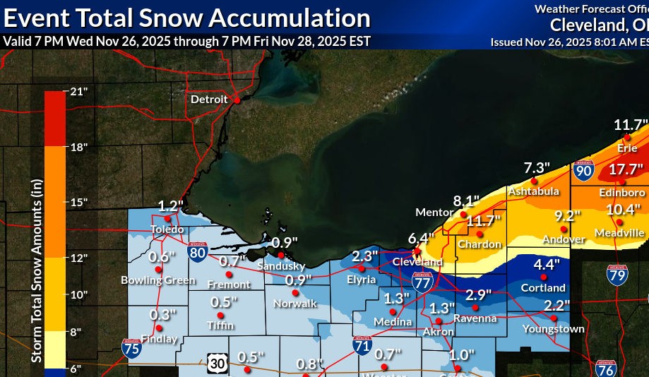
Nice to wake up to this... looking like a snowy Thanksgiving day. HZ012>014-089-251430- /O.EXB.KCLE.WS.A.0006.251127T1200Z-251129T0000Z/ Lake-Geauga-Ashtabula Inland-Ashtabula Lakeshore- Including the cities of Ashtabula, Jefferson, Willowick, South Russell, Roaming Shores, Eastlake, Middlefield, Wickliffe, Geneva, Mentor, Chardon, Bainbridge, Chesterland, Orwell, Willoughby, Conneaut, Burton, Andover, and Painesville 122 AM EST Tue Nov 25 2025 ...WINTER STORM WATCH IN EFFECT FROM THURSDAY MORNING THROUGH FRIDAY EVENING... * WHAT...Heavy lake effect snow possible. Total snow accumulations over 8 inches are possible. Winds could gust as high as 45 mph. * WHERE...Ashtabula Inland, Ashtabula Lakeshore, Geauga, and Lake Counties.
-
Nice! I didn't measure until this morning so there has definitely been a lot of compaction since yesterday.
-
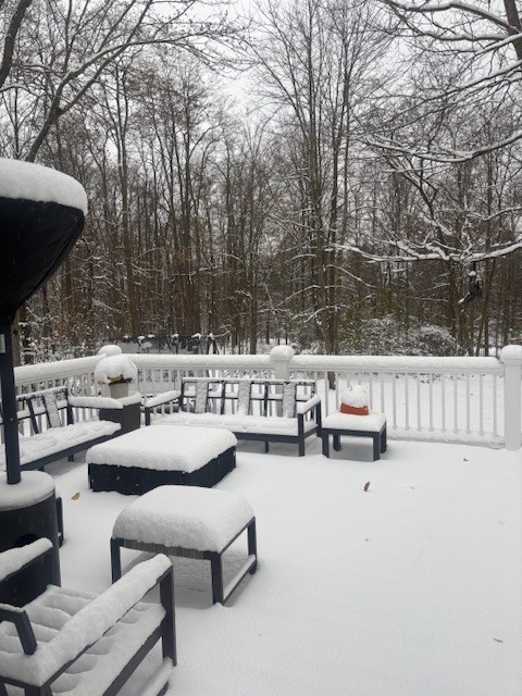
Closing in on 5". Much more on elevated surfaces... although the roads were pretty bad this morning.
-
1.5" overnight. We'll see what today/tonight delivers. Nice to see the snow again.
-
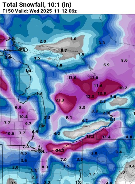
Seems like the models are shifting to a more NW wind direction. Still a long way out but some of the clown maps are interesting... CMC with a 2' bullseye over downtown.
-
This is a nice spread the wealth type lake effect event. Hopefully we can get a set-up like this when its cold enough for snow.
-
It has been a rough stretch from the westside of CLE on west to your area for sure. Hopefully more rain chances to come.
-
1.47" of much needed rain yesterday. We had a good run... I'm going to miss the San Diego like weather.
-
Finally had a good drink yesterday... 1.6" of rain IMBY. Looks like CLE missed most of the rain. Not sure it is going to be a good foliage season... the colors seem muted with rapid leaf drop.
-
It definitely felt like a short Summer. August turned out quite dry around here with just 2.7" IMBY. Noticing some reds starting to show up in the maples which seems early... but has been a common theme the past few years.
-
July turned out similar to June... 8.29" of rain IMBY, with 5.18" at CLE. We had a nice dry spell during July but it didn't last long. Looks dry and comfortable for the next week or so.
-
I finished June with 10.81" of rain. Still too wet to cut portions of the yard. Looks like CLE only had half of that amount. Most of the storms just missed CLE to the South and East.
-
Lots of tree damage locally from the storms last night. Must have been a downburst. Power is out in many places in Chagrin, South Russell and Bainbridge. Closing in on 9" of rain for the month... current total is 8.67".
-
Already up to 5.5" of rain for the month. Quite a few power outages around after the line came through last night. Surprised CLE only reported .35" of rain yesterday... must have been missed by almost every storm.
-
Finally starting to feel like Summer today. May was just an awful month around here... cool temps with nearly 6" of rain. CLE finished May -3.3 with 5.30" of rain.
-
Brutal to wake up to snow on the ground this morning. Looks like we are stuck in this pattern for awhile.
-
Picked up 1.2” last night. Hopefully that’s the last of it for the season. Looks scenic out there but I’m ready for Spring.
-
Really enjoying the longer sunsets. The remaining snowpack should be mostly gone by Friday. Nearly 2 full months of snow cover imby.
-
This year might be the longest we've had snow cover since I moved out to Geauga county. Despite snowfall being around average, we managed to avoid the big warm-ups and/or heavy rains.
-
The snowpack has taken a beating the past few days. Still solid cover IMBY but some patches of grass showing up in exposed areas. At this point I'm looking forward to warmer weather. It was a great Winter for snow on the ground.
-
Picked up an inch last night/this morning. 2-4" in the forecast today.
-
Great day yesterday. Picked somewhere around 7 - 8"... hard to tell with the strong winds blowing everything around. The storm was much better than expected.
-
Rain just flipped to ice and snow here. The temp didn’t get above 36 last night… still some snow remaining from part 1. Radar looks good to the west.
-
Recent model runs keep the low a little further southeast of here. Your area might flip to snow fairly quickly tomorrow morning. A low near PIT is usually a good track for northern Ohio.


