

NEOH
-
Posts
3,366 -
Joined
-
Last visited
Content Type
Profiles
Blogs
Forums
American Weather
Media Demo
Store
Gallery
Everything posted by NEOH
-
Picked up close to 3” overnight. Nice surprise snow. Looks like a couple more inches of lake effect today.
-
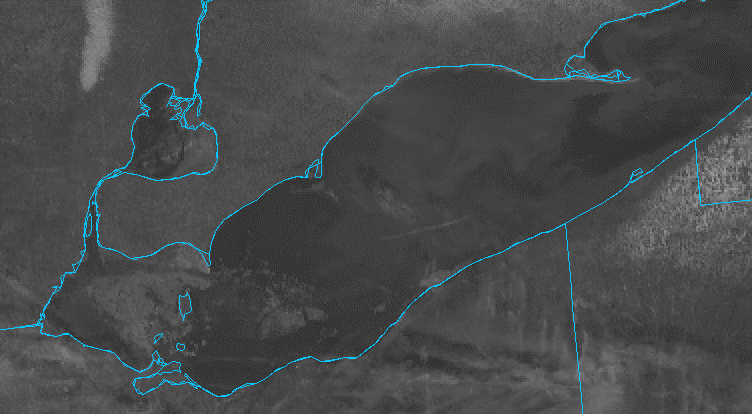
The snowpack has mostly melted IMBY. Just piles left at this point. Finally a decent view of the lake ice today. Not much out there east of the western basin. The upcoming warm temps and rain should melt quite a bit in the western basin.
-
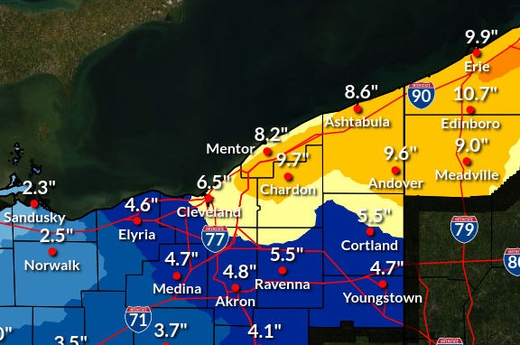
What a snowy week it was. Storm total of around 14” imby… very high ratio snow.
-
Dumping snow in South Russell right now. Noticed that CLE bumped snowfall totals... ...LAKE EFFECT SNOW WARNING REMAINS IN EFFECT UNTIL 7 AM EST THURSDAY... * WHAT...Heavy lake effect snow. Additional snow accumulations of 1 to 1.5 feet. Winds gusting as high as 35 mph. * WHERE...Ashtabula Inland, Ashtabula Lakeshore, Geauga, and Lake Counties. * WHEN...Until 7 AM EST Thursday. * IMPACTS...Travel could be very difficult. The hazardous conditions could impact holiday travel. * ADDITIONAL DETAILS...The heaviest lake effect snow will persist near the lakeshore this evening into Wednesday morning. Another period of heavy lake effect snow will arrive Wednesday afternoon and overnight, impacting the entire area. Snowfall rates may reach 2 inches per hour at times Wednesday evening.
-
Picked up around 2" last night. Going to need a big rally to get to the forecasted totals. The wind direction is ideal but the high winds must be disrupting the bands. ...LAKE EFFECT SNOW WARNING NOW IN EFFECT UNTIL 7 AM EST THURSDAY... * WHAT...Heavy lake effect snow. Additional snow accumulations between 8 and 12 inches. Winds gusting as high as 40 mph through this evening. * WHERE...Geauga County. * WHEN...Until 7 AM EST Thursday. * IMPACTS...Travel could be difficult. Gusty winds could bring down tree branches. * ADDITIONAL DETAILS...Initial round of lake effect snow will bring an additional 2 to 3 inches of snowfall through tonight. Another impactful period of heavy lake effect snow will begin this evening and continue through Thursday morning. Snowfall amounts during this timeframe will range between 8 and 10 inches.
-
Great to see Geauga was upgraded to a warning for 6-8". Winds are strong out there... already a lot of blowing snow.
-
Looking forward to it. Seems like the bands will be shifting quite a bit. It will be nice to have solid snow cover again. Still have some patches remaining from earlier in the month.
-
Snow cover is pretty much wiped out. Very patchy at this point. Started snowing around 5am and everything is now covered again.
-
Read this over the weekend... Consistent snow cover through the first 12 days of December has happened only four other times since 1938. Cleveland hasn’t seen bare ground since Thanksgiving, with snow remaining on the ground through every day of December so far — an early-season stretch that has happened only a handful of times in the city’s recorded history. Climate records from Cleveland Hopkins International Airport since 1938 show that Cleveland has had consistent snow cover from Dec. 1 through Dec. 12 in only four other years: 1958, 1974, 1976 and 2002. Snow-on-the-ground measurements come from a single site at Cleveland Hopkins Airport, where trace readings can occur even when substantial snow remains on the ground elsewhere in the region. The four Decembers that began with snow on the ground for all 12 of the month’s opening days did not all unfold the same way. In 1958, snow remained on the ground for nearly the entire month, finishing with 24 days of snow cover. In 1974, 1976 and 2002, snow lingered well into mid-December before warmer stretches briefly erased it, preventing those months from rivaling the most snow-dominant Decembers overall. In other words, an early lock-in doesn’t guarantee a snow-covered Christmas — but it does tilt December toward a more wintry-than-usual outcome. Historically, the most snow-dominant Decembers — measured by days with snow on the ground — include 1963 and 2010, when snow cover lasted 25 days, and 1958, 1989 and 2000, each with 24 days. But for those who feel like winter arrived early this year and never really loosened its grip, the data supports that impression — and shows just how rarely December begins this way.
-
Wow. That has to be near record early for that much ice on 12/15. We have an excellent snowpack out there... too bad it turns warm later this week.
-
Same measurements here. Should see an uptick in the snow this morning. Shorter fetch and dry arctic are not the best combo for heavy snow.
-
Looking forward to a snowy weekend. We've had a great start to Winter... best I can remember in quite some time. Going to enjoy the deep snow pack this weekend before the warm up next week.
-
The local snow gradient is quite noticeable over short distances. The corridor from Rt.87 south to 422 seems to have the most amount of snow on the ground. Thankfully I'm sandwiched right between that area
-
The few events we've had favored areas that cash in on a NW wind direction. The Bentleyville/Solon area seems to be ground zero. Payback for all the events that have a due westerly wind we miss out on
-
Picked up just under 2" from the snow yesterday evening and overnight. Nice LES band on the west side. None of the high res models seem to have that.
-
It was RN/SN mix earlier this morning now its primarily snow. Not much accumulation with temps above freezing but the roads are slushy.
-
12z high res models are pretty snowy for the higher elevations east of the city. Wonder how long we can hang on to snow tomorrow before changing to rain.
-
Excellent AFD from OHWeather. Worth a read - https://forecast.weather.gov/product.php?site=NWS&issuedby=CLE&product=AFD&format=CI&version=1&glossary=0&highlight=off
-
Shame to be on the warm side of the low. Hopefully it continues to trend further south as we get closer. Definitely more chances for snow as we get into the weekend.
-
I use https://weather.cod.edu/satrad/nexrad/?parms=CLE-N0B-0-24-100-usa-rad
-
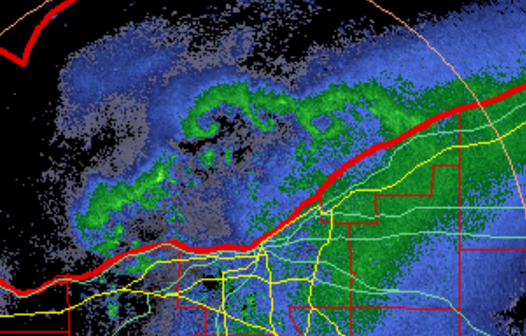
Cool to see several meso lows over the lake...
-
3"+ so far. Looks like deep winter out there. Excellent start to Winter.
-
Picked up 2.5" last night... nice surprise.
-
10” total so far. Looks like the hrrr was on to the southern band placement. Not sure how much more we’ll see today. The snow is very dense for lake effect.
-
Yeah the hrrr has been locked in with that band placement today. Not sure if it has a southern bias but we still have some wiggle room out this way at least. 8”+ looking likely.


