NEOH
-
Posts
3,368 -
Joined
-
Last visited
Content Type
Profiles
Blogs
Forums
American Weather
Media Demo
Store
Gallery
Everything posted by NEOH
-
Yeah, I have a few maples dropping already. Definitely a fall feel with the dark skies and lake effect rain coming down now. Last nights storms didn't pan out unfortunately.
-
Seems a little early but lots of color showing in the trees already. Looking forward to the squall line later today... then on to Fall tomorrow.
-
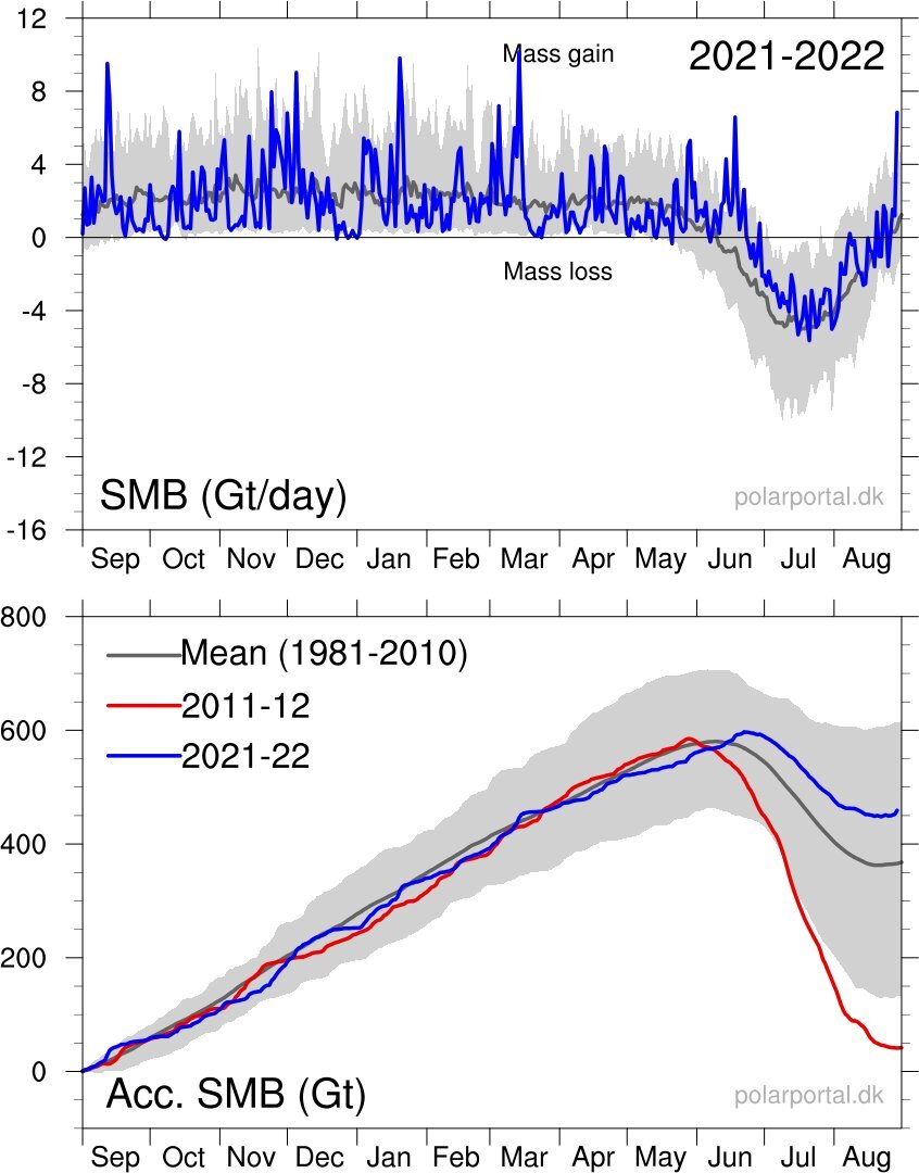
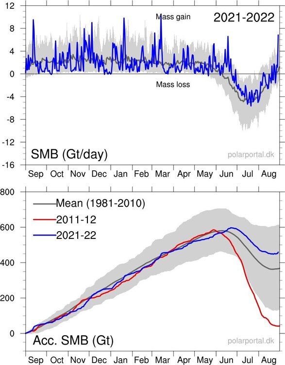
Read an article that the Greenland ice sheet gained 7 Gigatons of mass in just one day — the largest daily gain ever recorded during the summer.
-
First line of storms blew up just east of here on the Ohio/PA line. The area from Ashtabula on east has had the hot hand with storms this Summer. Hoping the line to the West can hold together for some action this evening. This has been one of the more boring Summers I can remember for t'storms locally.
-
Picked up 2.40" of rain since yesterday. It has been dry locally so it was definitely much needed around here.
-
Low of 49 IMBY this morning. This month has been a roller coaster with temps... seems like it has been windy every day as well. Ground is really starting to dry out with some brown showing in the grass. 2.25" of rain for the month here.
-
Just returned to CLE from New Orleans. Crazy that the airmass here feels very similar to NOLA.
-
Yeah, that's life next to the lake in the Spring. We've had a really nice stretch of weather the past week.
-
Finally have leaves on the trees. Only one's lagging are Oak and Locust.
-
Given how close you are to the lake its tough this time of the year. Looking forward to a warm-up though. Leaf out is still going slowly although we have made some progress over the last week.
-
Winter wonderland on 4/19. CLE recently reported thundersnow.
-
1..5” of snow last night. Checked out from the weather for awhile so wasn’t excepting that.
-
Didn't do a great job of measuring but estimating 6"... not counting the snow that came down this morning. Picked up another 1/2" or so with the squall that came through.
-
Woke up to a solid coating of snow… just under an inch. We’ll see what today/tonight brings.
-
Yep, I'm hoping for nothing more than a frontal passage with a few snow showers at this point. Spring doesn't come easily around here unfortunately.
-
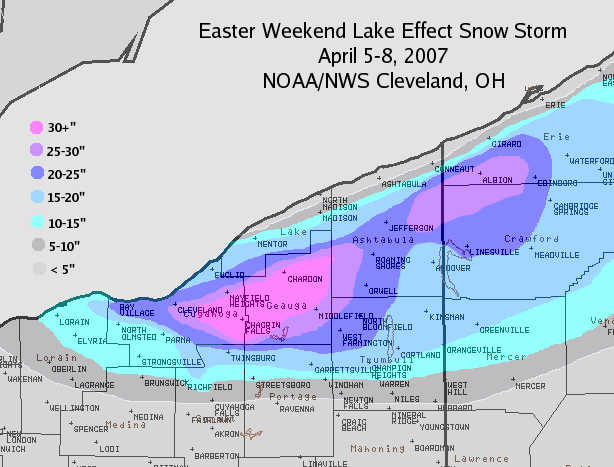
Definitely read to close the books on this winter. Pretty good winter overall considering how bad December was. Jan and Feb were cold and snowy... and we had snow cover for an extended period of time despite the brief thaws. DTA is probably keeping track but I'd guess we are at or slightly above average with snowfall at this point. Unless April 2007 comes along I'm ready to move on to Spring. That was the heaviest heart attack snow I've ever experienced.
-
Picked up 4” of lake effect last night. That was a surprise. Looks great with the ice on the trees.
-
Started as sleet and freezing rain last evening and continued all night. No snow at all. Props to whatever model showed this (NAM maybe?). Everything is coated in ice with light snow falling now.
-
You might be in a good spot for this one right near the shoreline.
-
Yeah, far from an interesting storm. Will add a couple of inches to the annual total. Wonder if there will be some higher totals on the immediate lakeshore though.
-
Just a guess but I think the NAM will be wrong
-
Looks like a general 3-4" snowfall coming with the storm. Kind of hard to get excited about it after the warm weather the past few days. Still have snow patches in the shaded areas but most melted.
-
First thunder of the year this morning. Still snow in parts of the yard... amazing how resilient it is.
-
Snow cover should be reduced to patches and piles today or tomorrow. Torching out there with full sun... really amazing how strong the sun feels this time of the season.
-
Stopped home and measured just under 5". Looks like the lake effect is winding down now as the winds are turning.