

CT Valley Snowman
-
Posts
4,681 -
Joined
-
Last visited
Content Type
Profiles
Blogs
Forums
American Weather
Media Demo
Store
Gallery
Posts posted by CT Valley Snowman
-
-
Friday PM might be your best chance Wolf. Perhaps tomorrow before 9 AM might be OK but that's probably not enough time or too early and even thats's not a guarantee.
-
Friday looks unsettled and cool, Saturday looks like a decent day. Sunday has a bit more uncertainty, but I would lean decent as well, perhaps a bit cool along the coast and some PM clouds entering the region, with perhaps a shower or two in the far west. I'd be a bit more concerned to the west and south of our region on Sunday. Monday is still a ways out but looks a bit dicey.
-
EPS is not quite as aggressive at completely erasing the lower height anomalies but is improving as well. I'm not expecting a overly warm and completely dry weekend up in the lakes region of Maine where I plan on going but if we can avoid the huge ULL of doom and just contend with a some instability clouds or a pop up passing shower or two and temps near 70 I would be very happy.
.thumb.gif.1c9a08aaca2f2477b7d189f074adc2a8.gif)
-
 1
1
-
-
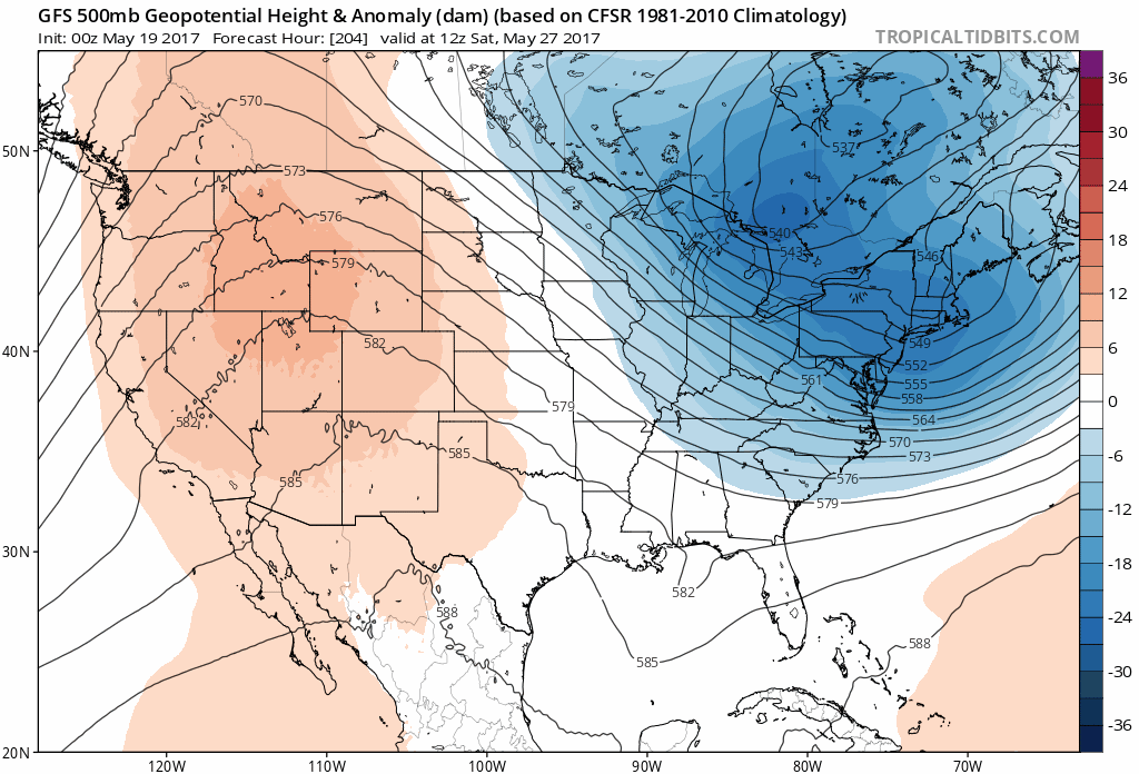
GFS OP is really backing down on the deep ULL/trough Memorial Day weekend on the past few runs. It Now has most of New England in the 70's and 80's over the holiday weekend. Below is the trend of the past 4 runs valid 12z Saturday. The Trough basically splits in 2 and a bit of a SE ridge starts to flex it's muscles on the latest runs.
-
Looking forward to 91-92 here on Thursday. Bring it on.
-
I'm sure Kevin will argue that the trough axis will be west on Memorial Day weekend, and it very well may start off that way but it still doesn't look like any kind of heat. Perhaps moderate humidity before the trough axis swings through , hopefully it's not too much of a washout as I was trying to get up to Maine with some decent weather. Obviously things could change when we're dealing with this amount of time range.
-
Mothers day cookout may be turning into takeout here.
-
We bang
-
If I do move up it would most likely be to east slopes of the southern Berks or the Northwest Hills. Probably not way up on the spine but on the escarpment at like 1000-1200 where you can still get to civilization in 20-25 minutes. Granville MA is like 1200 but you can get down to Westfield in like 15 minutes. North Granby and Barkhamsted CT are similiar.
-
I didn't do the ALB area...but here is my map of the December 1992 snowfall

Disgusting. One of the worst storms ever. My Dad was working in Dalton Ma and was stunned at how little snow we had at home. I kept looking up at the sky literally seeing the flakes pounding high up in the air but never making it to the ground.
-
Cranky folks tonight. I'm off to bed. Hopefully the morning light will bring peace and good-will among men. Lol.
-
BDL still averages 49" so you're probably the same. That's not bad.
I'm just under 45" in WeHa.
Last year I did slightly better than BDL. The blizzard gave me a couple inches more being east of the river and I think I had about 6 inches more for the season but that was a big time longitude situation. The drive east on state route 190 was a bigtime gradient,probably like 70-75 inches in Enfield. 75-88 in Somers, 88-103 in Stafford in like a 20 mile drive east.
-
I'm convinced my town is just about the worst in all of CT for the shadow / dry air channeling down the valley effects. I've seen the HFD area do slightly better than here in those situations. My latitude makes up for it so I probably still average about 3-4 inches more per year than HFD.
-
He also benefits from inserting his ruler into the snow at less than 90 degrees.
I wonder if his brother lives in Lunenburg?
-
Kevin benefits more from a marginal temp profile paste job up on his hill than true upslope. When I lived in Ellington at 400', Most big storms, 12+, he got maybe an inch or 2 more than I did, but he cashed in on a couple slushy coatings at my place where up on the hill was like 2-3.
-
Snowtober still grabs my attention more than any of the recent blizzards. The shotguns and flashes all night and the destruction that was visible in the morning with that epic deform band of the ages over GC. Still don't think we will see anything like that again in our lifetimes.
-
Here is one more:

Absolutely stunning pics !!!.
-
Somers has very high points on the Tolland/Ellington line. In fact Soapstone Mountain which is less than 10 minutes from me is near 1,000k. It's crazy though..how fast you lose elevation as you go down into the center of Somers twds Enfield
That wxradio Herb/David had on in the background used to get signals from a transmitter on top of Soapstone. there's some great running/hiking trails there and a fire tower at the top with great views
Was just up there last week. 1075 ASL is what the maps say. Beautiful view right on the edge of the valley. The escarpment is real sharp right there. . Its about 18 minutes from my house.
-
Digging up old wounds. That ride from Enfield to Union on 190 had about a 20 inch snowfall difference.
-
euro was correcting East for several runs in a row . Rgem shifts twice in a row more of us should have jumped
-
Euro Ensembles and Op locked in the day of the event. This model suite just took a massive hit with this storm.
-
The Rgem snow map west of ORH-Tolland is brutally low. This has honestly been my go-to model outside of the Euro in many events. When is the last time it was this far off the day of an event?
-
Im totally stunned at the model variance. Nervous feeling in the pit of my stomach.
-
any general ideas of QPF on the RGEM?
.gif.e9c4b9db79e50e4fe4df2b5e9c63ca9f.gif)

Model Mehham
in New England
Posted
I like the look overall for the lakes region of Maine where I will be located late Friday- early Monday. I'm not sold on the showers likely on the point and click for Memorial Day yet either, especially during the morning up there. Hopefully we can sneak in a dry Memorial Day parade and let the showers move in when we're driving home in the PM.