

Orangeburgwx
-
Posts
2,592 -
Joined
-
Last visited
Content Type
Profiles
Blogs
Forums
American Weather
Media Demo
Store
Gallery
Everything posted by Orangeburgwx
-

Southeast Sanitarium - A Place to Vent
Orangeburgwx replied to Jonathan's topic in Southeastern States
NYD redemption snow, thanks NAM!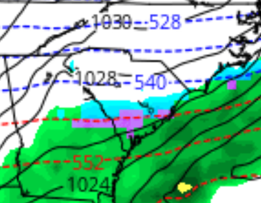
-
Southeast Sanitarium - A Place to Vent
Orangeburgwx replied to Jonathan's topic in Southeastern States
just don’t go on Amazon, the most expensive there was $3500 -
Southeast Sanitarium - A Place to Vent
Orangeburgwx replied to Jonathan's topic in Southeastern States
looked it up, cheapest I saw was $50, most expensive was $600 -
Southeast Sanitarium - A Place to Vent
Orangeburgwx replied to Jonathan's topic in Southeastern States
yes -
Southeast Sanitarium - A Place to Vent
Orangeburgwx replied to Jonathan's topic in Southeastern States
FLURRIES IMBY -
Southeast Sanitarium - A Place to Vent
Orangeburgwx replied to Jonathan's topic in Southeastern States
I think we can all agree the term “apps rubber” was the highlight of the night -
Southeast Sanitarium - A Place to Vent
Orangeburgwx replied to Jonathan's topic in Southeastern States
maybe some light drizzle over night but nothing major -
Southeast Sanitarium - A Place to Vent
Orangeburgwx replied to Jonathan's topic in Southeastern States
43 but it has done plummeted to 35, calling for a low of 29 but I think it might get colder -
Southeast Sanitarium - A Place to Vent
Orangeburgwx replied to Jonathan's topic in Southeastern States
desperate maybe? -
Southeast Sanitarium - A Place to Vent
Orangeburgwx replied to Jonathan's topic in Southeastern States
0z NAM already a little flatter and less stream separation at 15hr -
Southeast Sanitarium - A Place to Vent
Orangeburgwx replied to Jonathan's topic in Southeastern States
Would be something if it shifts that much... got 4 days (16 runs) to do it. -
Southeast Sanitarium - A Place to Vent
Orangeburgwx replied to Jonathan's topic in Southeastern States
“Too cold to snow” huh?... go tell that to Antarctica, Russia, Canada, Serbia, and any tall mountain range like the Rockies, Alps, and Himalayas. -
Southeast Sanitarium - A Place to Vent
Orangeburgwx replied to Jonathan's topic in Southeastern States
Actually I had my dates backwards, it was February 2010 when we got that accumulation in my area. -
Southeast Sanitarium - A Place to Vent
Orangeburgwx replied to Jonathan's topic in Southeastern States
the last decent dump Orangeburg got was in February 2009 (8.5 inches, got an inch an hour off that storm). I did get lucky and managed to see a few flurries as this last system cleared out... but it sucks living in this part of the state because we basically need a digging cold front plus a clipper low moving up from the Gulf to have any significant accumulation. -
Southeast Sanitarium - A Place to Vent
Orangeburgwx replied to Jonathan's topic in Southeastern States
because Chuck Norris does not approve..(sorry I had to use that joke) but in all seriousness, it won't because it wants our hope shattered like glass

