-
Posts
400 -
Joined
-
Last visited
Content Type
Profiles
Blogs
Forums
American Weather
Media Demo
Store
Gallery
Posts posted by CCHurricane
-
-
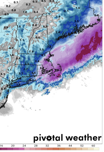
12z NAM 3k just won't quit Cape Cod.
A true scraper that feeds moisture and delivers a plowable event (3-6 inches) for most east of the Canal.

-
 1
1
-
-
Just now, Snowcrazed71 said:
Didn't the Euro last night also show some kind of pullback of some of the snow. Almost like an inverted trough ish. That could be something, but again, it would probably only affect areas all the way out east
12z Euro has already backed off that solution unfortunately...
-
 1
1
-
-
@RUNNAWAYICEBERG @HoarfrostHubb @40/70 Benchmark @ORH_wxman
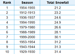
Lowest 10-Years of Snowfall for Worcester Area
-
 1
1
-
-
18 hours ago, SouthCoastMA said:
Maybe @CCHurricane and I can catch a few OE streamers Sunday Night / Monday, per the hi-res stuff. Looks pretty light, but could be festive in spots. D-1"?
Looks like this started on the earlier side. Will be interested to see how these bands move across and set up here on the Cape.
Wellfleet and Yarmouth looks to be in a good spot at the moment.
-
 2
2
-
-
Tapped out between 2-2.5” here in Barnstable. Once we lost the heavy echos of the main precip field, the accumulating snow went with it.
All things considered, an enjoyable event with an interesting snowfall distribution from Boston to Cape Cod.
-
 2
2
-
-
-
-
Can confirm. Just drove downtown BOS to split. Temp 31 -> 34, decent snow to rain.
-
Just now, CoastalWx said:
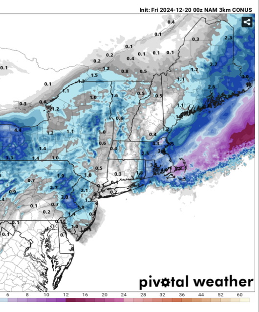
This could be a heck of a bust for BOS down to interior SE MA. And I mean in a good way. Compared to the forecasts I saw.
Last night’s 00Z NAM from the top rope! A winter of positive busts, could you imagine?
-
 1
1
-
-
20 minutes ago, Layman said:
There's a thread for that
Thanks, checked but didn't see that on the forum page.
-
-
Just now, 78Blizzard said:
Need to see some other models supporting this closer late strengthening development.
Would be quite the shift just 18 hours out.
-
-
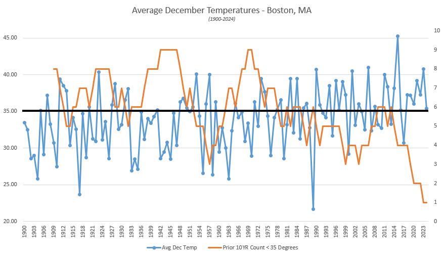
Here in Boston we are currently tracking for our "coldest" December since 2017. Zoom out a bit further however, and it just goes to show how the broader shift in climate is moving the goalposts as to what is perceived as being "cold".
- 2000-2010: 6 of 10 years @ 35 degrees or colder
- 2010-2024: 2 of 14 years @ 35 degrees or colder
-
-
-
-
-
Mount Mansfield Snow Stake reporting 12 inches of snow? That can't be correct...is it?
Would be an a record high for this early in the year, dating back to 1954.
-
2 minutes ago, Blue Ridge said:
SRQ is still transmitting altimeter data, but nothing else.
https://mesowest.utah.edu/cgi-bin/droman/meso_base_dyn.cgi?stn=KSRQ&unit=0&timetype=LOCAL
Looks like a few +100mph gusts may have caused issues.
-
St Pete new high gust to 91mph @ 10:15PM.
Did we lose the Sarasota Airport station? Looks like updates have ceased.
-
8 minutes ago, WolfStock1 said:
Believe there’s some nuance to this data based on this gauge location. Looks to be exposed to a north wind. The three other Tampa Bay gauges all are running many feet BELOW normal, as the ocean has evacuated towards Tampa Bay’s mouth.
-
 6
6
-
-
7 minutes ago, SnowGoose69 said:
00Z Euro makes landfall at St. Pete Beach
Goalposts narrowing between Treasure Island & Longboat Key. Regardless of Milton's exact landfall location, impacts will be devastating, yet on a relative basis a St. Pete Beach landfall would be close to a worst case scenario...
-




March DISCO/OBS: Please End It
in New England
Posted
Black line is the 30-year rolling average; for BOS the 1930-1960 period was around 32.7F. Current "climate" is about +2F greater at 34.6F.
Most notable is that pre-2002 and over the course of +125 years, BOS did not once see a Dec-Mar winter where avg. temps were +37.5F. Since 2002 we've seen 6 years +37.5...
https://xmacis.rcc-acis.org/