
paulythegun
-
Posts
808 -
Joined
-
Last visited
Content Type
Profiles
Blogs
Forums
American Weather
Media Demo
Store
Gallery
Posts posted by paulythegun
-
-
Icon shifted a little south from the earlier run.
-
 3
3
-
-
46 minutes ago, Solution Man said:
On to the 18z Happy Hour, Watcha drinking
Virga Tonic

-
 8
8
-
-
VirgaFest2024 over the mid-atlantic right now
-
4 minutes ago, Terpeast said:
Thats from the same run but two different time frames
my mistake - reposted below. looks more significant on teh real thing!
-
1
-
-
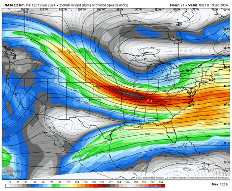
son of a gun, posted the wrong gif. here's that jet streak trend.
-
3
-
 1
1
-
-
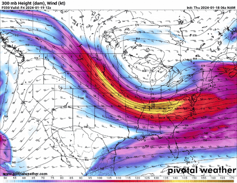
Look at the jet streak shifting south (6z nam vs 12z nam). Puts DC proper (and areas just north) closer to the left exit area.
-
8
-
1
-
-
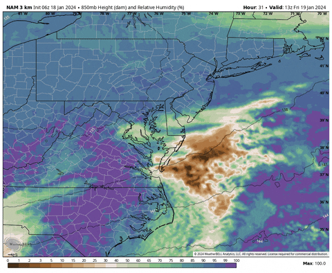
Love the MOISTNESS trend at mid-levels. this is comparing the last couple nam 3k runs
-
3
-
1
-
 1
1
-
-
-
Expect the weeklies to change tomorrow since the eps kind of caved to the gefs and geps today, but I saw this on the control and it reminds me a bit of current pattern
.
Get this to weatherpeens! -
9 minutes ago, NorthArlington101 said:
Live and die by the GRAFOUTSTANDING PERFORMANCE!!!
"WE GOT GRAF'D!!"

-
1
-
2
-
4
-
-
-
18z RGEM is a little dryer (EDIT: it's tough to really tell with this map) but still lots of light snow for dc and points north. Philly jackput with the inverted trough.
https://collaboration.cmc.ec.gc.ca/cmc/cmdn/pcpn_type/pcpn_type_gem_reg.html
-
Model grab bag.
JMA total precip (looking very good!)

12z ARPEGE (JUICY!!!)

ACCESS-G shows about 0.25 to 0.35 in liquid equivalent, tough to tell with this scale.

And of course the UM(mmmmm) model is the driest. does UM have a dry bias? we'll see

557ww model...well...it doesn't have many good parameters other than 700mb RH and that looks north throughout the event, including at 00z on saturday. Though this is the 00z run of 557ww. so take it with a grain of salt until the 557ww computer processes the new 12z data.

And last but not least is the RHMC model, which I assume stands for Ronald McDonald House Charities. Looks like widespread.....1 and 2 throughout the forum.

-
1
-
3
-
4
-
-
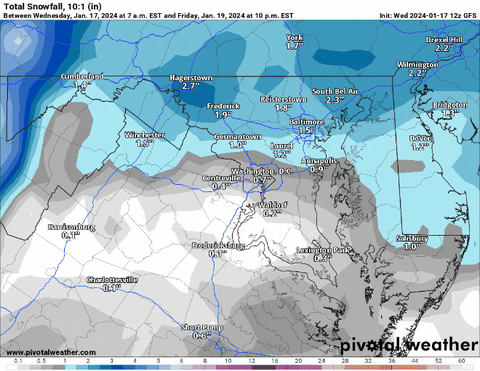
How much for Georgetown?
Hahaha this should be a running joke for now on-
1
-
-
-
-
This is my favorite storm of all time. I saw the radar the night before. I was in sixth grade and remember thinking, “That looks like it’s headed right for us.” And yet Bob on NBC was saying we were just gonna get grazed for an inch or two.
For me, the Jan 2000 surprise storm led to over 2 decades of radar hallucinations. Still, no regrets.-
4
-
3
-
-

.
I was mourning the loss of the squall line tomorrow in my own bitter, bitter way. carry on all! I’ll keep my whining to the panic room. Squall lines are fun though!
-
We all should have been smart enough to know that arctic front passages of the kind we’re about to experience (without any sort of clipper wave associated) don’t make it across the mountains in any real way. Talking about tomorrow’s fake snow squall.
-
 1
1
-
2
-
-
-
15z SREF snow mean

-
2
-
-
-
What is the precedent for deleting a thread?
-


Jan 19th Storm OBS Thread
in Mid Atlantic
Posted
REMINDER: Snow on top of your car is INCREDIBLY DANGEROUS. Do not touch it or try to remove it!