
paulythegun
-
Posts
778 -
Joined
-
Last visited
Content Type
Profiles
Blogs
Forums
American Weather
Media Demo
Store
Gallery
Posts posted by paulythegun
-
-
I need an app that wakes me with an alarm any time snow rates go above an inch per hour.
-
 1
1
-
 1
1
-
-
7 minutes ago, Terpeast said:
Not 100% sure for DC south, even mby. If the 18z euro jumps north from 12z, I’m pulling the fire alarm on this
Yeah it might be time to delete the thread and start a new one if that happens

-
1 hour ago, WVsnowlover said:
Strange that 10:1 is higher than Kuchera. Definitely looking like the potential is there for the biggest snow of the season for many.
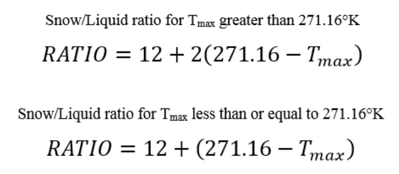
Kuchera (as I understand it) is highly sensitive to the maximum temperature in kelvin in up to 500mb (Tmax below). I ran the calculation for DC for the Euro where the max temp is 273..15 in Kelvin (0 degrees C) during the height of the storm and that translates to 8.01 to 1 ratios using the Kuchera method.
-
2 minutes ago, Interstate said:
Who was it that was asking for a Special Weather Statement on Tuesday... well here you go
Move your cars!!!
-
-
*to the tune of American Woman*
JET STREAK LEFT EXIT REGION

-
4
-
-
Time to beg @MikeTFox5 to post the latest Graf Model. Will report back.
-
2
-
-
If this thing arrived during the day, with this middling airmass (and middling moisture that isn't going to overcome temps outside of localized banding), I guess it would just be some wet white rain right? For the city at least. At least if you buy NAM.
-
1 minute ago, Interstate said:
Wouldn't that be a 50% increase?
haha right.
Dew points kind of suck on this run....never gets below freezing inside the beltway.
-
QPF up 150% at DCA on NAM!!!!
....from 0.2" to 0.3"
-
 1
1
-
-
NAM is a wiggle south with the low, both 3k and 12k (vs 06z).
-
34 minutes ago, stormtracker said:
I don't think so. Maybe a snow advisory.
Getting a Traveler's Advisory was like when you wanted McDonalds and your parents saying "we got McDonalds at home".
Don't forget to move your car during the Special Weather Statement!

-
2
-
7
-
-
Surprisingly few posts. Is he deleting his wrong predictions? I respect that
https://twitter.com/search?q=hounds from%3A%40bigjoebastardi&src=typed_query&f=live
https://twitter.com/search?q=hound from%3A%40bigjoebastardi&src=typed_query&f=live
-
3
-
-
1 hour ago, Ji said:
How do latest weeklies look for March ?The last week of March looks rockin'!

-
2
-
 1
1
-
-
The Models! They say "0 inches of snow" and then they say "10 inches of snow". The Models cannot be relied upon! With their various inches!
-
Mechanics with today’s heavier precipitation was south. I think that continues thru Tuesday
I've got my sled ready!!! -

RIDE OR DIE!!!!-
2
-
-
A helpful north trend on 12z eps for those rooting for it to go so far north we get dry slotted out of rain
-
3
-
-
-
-
-
A West-based NAO born and raised
Over Greenland was where I spent most of my days
Chillin' out, maxin', relaxin', all cool
And all blockin' the arctic airmass poolWhen a couple of highs who were up to no good
Started suppressing waves in my neighborhood
I got one southern slider and Ji got scared
He said, "You're movin' winter back to March it's not fair"-
2
-
20
-
-
TIME FOR GFS TO SELF-TERMINATE. Sad scene. Cantore sees it off.

-
1
-
-
3k NAM (through 60 hours) is some combination of faster and/or further northeast of GFS. pretty good distance too. 12k NAM is like a half a day faster ahead with the whole system through 84. for what that's worth (literally nothing. negative information in fact)
-
1
-


The Weekend Rule? Saturday 2/17 - The Icon Storm
in Mid Atlantic
Posted
GRAF is in