
ers-wxman1
-
Posts
2,525 -
Joined
-
Last visited
Content Type
Profiles
Blogs
Forums
American Weather
Media Demo
Store
Gallery
Posts posted by ers-wxman1
-
-
Just now, Imgoinhungry said:
What is your predicted total snowfall for Frederick?
I think Frederick MD will see solid warning level snow. 5-8 on the front end thump before sleet transition, maybe another 2-4 on the transition back to snow.
-
Track of the surface low also not necessarily the most important factor. Classic snow events for the Mid Atlantic need a strengthening upper low closing off , deepening coming near or just south of our area. This is a progressive vigorous punch and not much phasing for our area, best dynamics go north in the CCB.
-
 3
3
-
 1
1
-
-
I know everyone is analyzing a stronger CAD with each model cycle, but it really is not going to matter. This is not a true arctic airmass and the cold air being dammed in is marginal at best. Source is not deep. Hence we hold on to the front end thump then the shallow cold rapidly erodes. This is why we are seeing such fast changeovers today. Upper level low also not closed and is weakening as it approaches our latitude. That isn’t favorable for the column either. It’s a tough storm for our area outside the favored zones, even some of these areas north of I-70 into southern PA unfortunately will change to sleet for a while. December modified cold airmass not ideal.
-
3
-
 1
1
-
-
Our best shot for heavy snow outside the favored areas well north and west will come on the front end thump. The CAD unfortunately is marginal and not deep which will erode quickly after 18z. Some areas such as nova, central MD, north of 70 could pick up 3-5 in the first 3-4 hours of the event before changing to sleet then rain. Need the thump. Wrap around CAA never set in stone and it appears the best forcing per the upper low energy will be north of the area in PA/NJ. Lighter snow on the backside for our area, let’s hope we can keep more forcing before everything shifts out.
-
2
-
1
-
-
2 minutes ago, Weather Will said:
Yes. The NAM should be replaced before 2024.
Perhaps you should take an introductory course in NWP so that you can actually learn how to interpret a model. Or perhaps read up on some of the material discussed earlier on how to use the NAM at this range. You don’t look at the exact amounts, you watch the trends and the evolution and what the run to run differences/similarities are. Rarely does anyone take one model 100% for qpf, it’s always a blend. Most important information is how the model is handling the moving pieces that will become the weather event. These higher “snowfall” amounts you are seeing do not take into account sleet/ice which can jack up the amounts. What I take from the run is the penetration of the warm air...good front end thump then more expansive mixing and rain then this AM.
-
4
-
 1
1
-
-
7 minutes ago, Weather Will said:
We all need to write Uccellini and get them to speed up the replacement of the NAM.... let’s see, it overstates QPF, it’s too warm, it”s too cold and clueless outside 2 hours. We should not pay the bill for the electricity to run this model!!! But you got to love the 50 inches!!!
Do you actually have a clue what you are even saying?
-
1
-
1
-
-
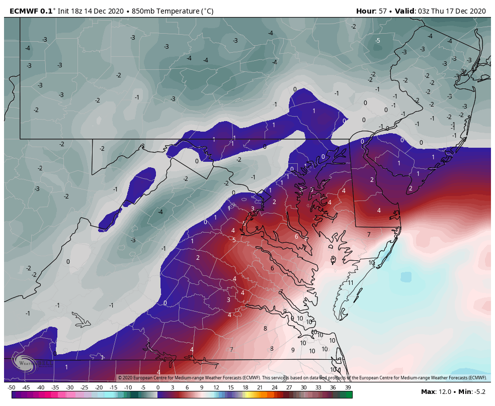
46 minutes ago, psuhoffman said:
This is where our area starts to lose the thermals on the WAA side of the storm. It's a step back on this part. The red line is the 850 but like you said at this point the layer is isothermal from 850 down so its pretty much the rain snow line there...you can see what qpf came before the transition...you can estimate how the area did...northern zones hold on 1-2 hours longer...south of DC gets very little snow before going to rain.

1z here is about the worst look for the thermals. This is the NW extent of both the surface and mid level warmth. I have estimated the rain and sleet lines here by tracing the 925 and 850 0 lines.

2 hours later by 3z the temps are crashing and I would estimate everyone NW of 95 is going back to snow or has already. There are some pockets in the zone of subsidence NW of the developing banding of warmth but if they are between heavy bands at the time your not missing out on much accumulation anyways...point is I think we can assume from 3z on anything that falls is snowfall from 95 NW

SO this last plot is the qpf that falls after that...and this is where the bulk of the snow comes from. This looks great...I would sign up for it...but I do NOT like living on the deform love as 90% of the storm. That can disapear real quick if things don't come together right. But the euro has been remarkably consistent with that in our area so maybe... so there is good and bad here...but again I am nervous relying almost entirely on the back side. Even up here its only about 3-4" before a flip to sleet...the other 14" if gives me is from the deform. If that happens GREAT but my rule is usually to treat that as bonus.
Anyways... hope that helped.
This is a very good analysis.
-
2
-
-
I posted this by accident in the long range forum and meant it to be here...I’m happy to post here but every time I post anti snow or show a trend and give an analysis it’s taken as negative or harsh. I watched over the weekend at day 5 model hugging the snowiest solutions, it’s rare for it to work out that way area wide especially with such a marginal temperature setup. Conversations among colleagues can get like this...diverging opinions and Mets can be sensitive I will say that. But inevitably, the very grids a forecaster makes come from a blend of every model you see out there including the NAM, SREF, GFS, EURO etc its a blend of all and ensembles. You can gain clues into how a system is evolving from the NAM even at 48 and 60 hours. Take all the runs today...all of them are trending toward a well north and west setup of snow, rain more dominant east and you can’t just toss the NAM it’s showing this consistently run after run.
-
11 minutes ago, psuhoffman said:
I think their being harsh but I noticed your not really predicting anything much different then most but it’s the tone. Instead of focusing on a he positives for the parts of the region that get snow you are focused more on the fail aspects. I get crap for that too sometimes. No one likes to hear depressing news. Even if they know it’s true.
I agree. Thanks for sharing this. I can see what you are saying for the eastern areas, though I am saying generous snow amounts just well north and west.
-
1
-
-
Just now, Always in Zugzwang said:
No apologies needed...I don't think the particular thread you put that in matters all that much. I knew what you were talking about. What you mentioned could apply to damn near any event around here to be honest, in terms of model hugging, tossing, etc. I'll admit myself to being weenie-ish when it comes to snow (we all are to an extent, aren't we?), but I also have to respect the science and reality of what's being shown, even if it's not favorable.
I definitely agree
-
1
-
-
2 minutes ago, North Balti Zen said:
He is being deliberately obtuse - we have had medium and long range threads for YEARS and anyone who wanders into one sees discussion, some serious, much not, over things that are phantoms. He knows this.
Get a grip! I accidentally posted here instead of the other thread.
-
4
-
-
1 minute ago, Always in Zugzwang said:
If you're referring to @ers-wxman1's comment above, he may have intended that for the other thread about this upcoming event. I don't think he's being "obtuse".
I'd rather have far fewer @Ji-type comments with sarcastic (and whining) posts about how a 240 hour forecast took away his 15" snow or how getting a foot is somehow a fail...and far more @ers-wxman1-type posts that are loaded with useful and informed content, even if a bit jaded at some people's attitudes and occasionally harsh on the reality of marginal setups!
My apologies. Wrong thread.
-
1 minute ago, Maestrobjwa said:
Did you mean to put this in the other thread?
And ya know that's the psychology around here...yeah it doesn't make any sense, but that's how it is, lol But please don't stop posting...we need more mets here, to break down the good, the bad, and the ugly!
I’m happy to post here but every time I post anti snow or show a trend and give an analysis it’s taken as negative or harsh. I watched over the weekend at day 5 model hugging the snowiest solutions, it’s rare for it to work out that way area wide especially with such a marginal temperature setup. Conversations among colleagues can get like this...diverging opinions and Mets can be sensitive I will say that. But inevitably, the very grids a forecaster makes come from a blend of every model you see out there including the NAM, SREF, GFS, EURO etc its a blend of all and ensembles. You can gain clues into how a system is evolving from the NAM even at 48 and 60 hours. Take all the runs today...all of them are trending toward a well north and west setup of snow, rain more dominant east and you can’t just toss the NAM it’s showing this consistently run after run.
-
1
-
-
If the NAM is “out of range” and mauls the area with snow it’s hugged and adored by all and they can’t wait for the next run, much the same over the weekend with the GFS and Euro giving 15-20 inches “out of range” at day 5 with 90 pages of comments. When the NAM is unfavorable and analyzed its bad, out of range and nobody wants to see it or hear about it.
-
2
-
-
10 minutes ago, mattie g said:
You said the NAM is a disaster and then proceeded to analyze it. Why? What good does it do to provide any sort of real analysis on a run of a model that sucks at range?
My response was in jest, but with a bit of a dig for the analysis you provided without qualifying it at all by saying it's just the NAM and is among the least likely of solutions to play out.
A little bit of a snarky response, but more in jest, as noted above.
I appreciate the input of a pro as much as anyone, but I can't help but feel that an analysis of the NAM at range by a pro was a *wee bit* of a bad faith post.
If the NAM is “out of range” and mauls the area with snow it’s hugged and adored by all and they can’t wait for the next run, much the same over the weekend with the GFS and Euro giving 15-20 inches “out of range” at day 5 with 90 pages of comments. When the NAM is unfavorable and analyzed its bad, out of range and nobody wants to see it or hear about it.
-
3 minutes ago, WinterWxLuvr said:5 minutes ago, ravensrule said:
Again we all appreciate your excellent thoughts but to use the NAM as gospel 48 hours out isn't the best idea. Please keep posting and ignore the background noise.
It’s not gospel, it’s indicative of the evolution of the pattern. The model is not worthless beyond 48 hours. I happen to work with the hard working employees that spend millions to make these models run year round, that dedicate their lives to making NWP better and people just trash them like it’s a wind up toy.
-
1
-
1
-
-
1 minute ago, WinterWxLuvr said:
Take your ball and go home? I held back on posting this but I distinctly remember the progression here. You once went big on a storm and busted. Ever since you have poor mouthed every chance that we’ve had. And have busted low in nearly every one of those. Now you’re mad because people don’t like it. People might not like me posting this but it’s the truth.
You obviously know more than most. You’re a pro after all. Maybe just give us what you see and why. Lose the absolute certainty of it all. You need to question why you’re getting the responses that you’re getting.
This is ridiculousness!
-
1
-
-
1 minute ago, mattie g said:
Thanks for the rundown. We all fully expect that the NAM will verify at this range. Time to grab some rope...
Ok I’ve had just about enough posting in this place. No wonder you can’t retain any real meteorologists here.
-
1
-
-
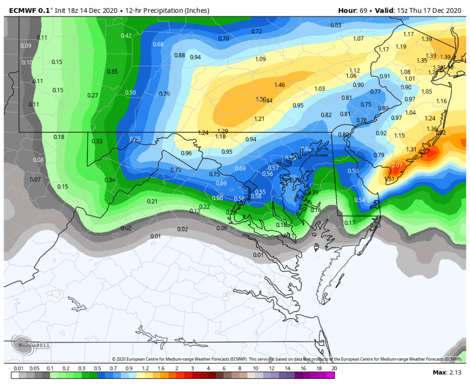
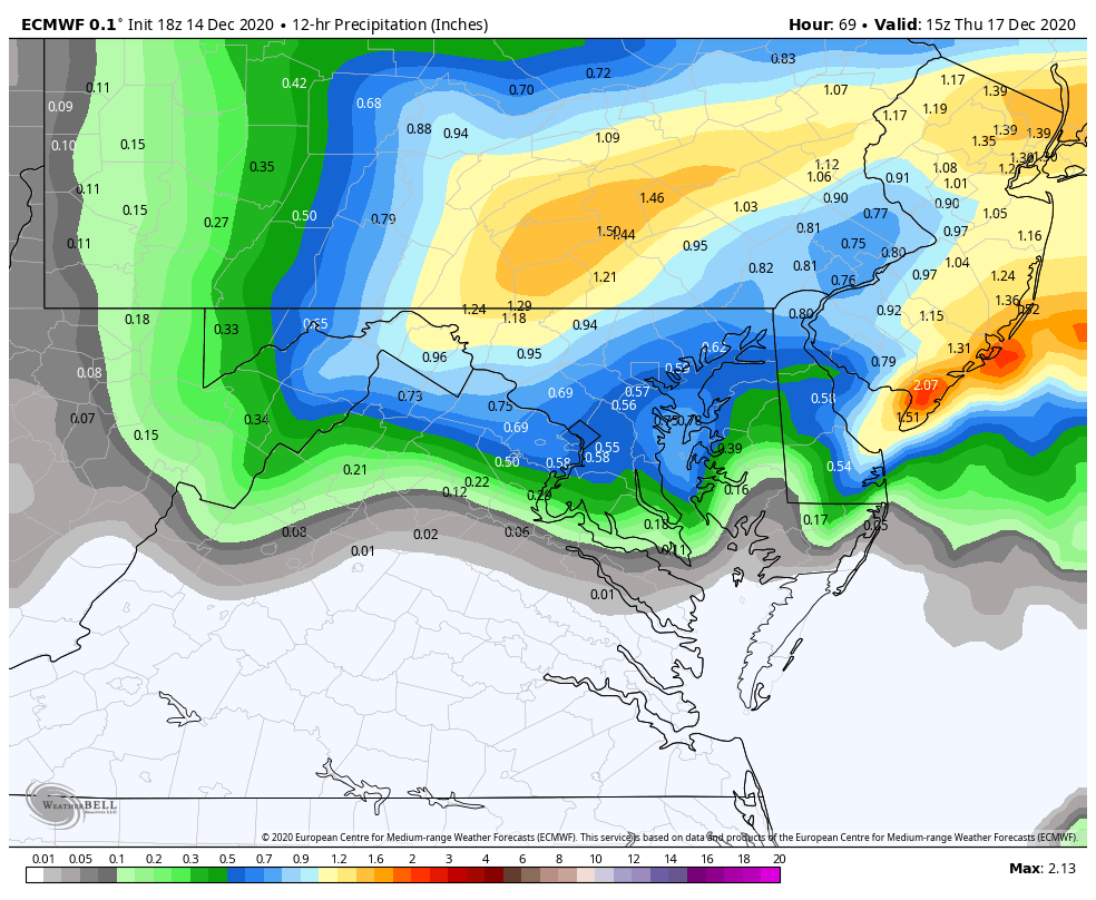
18z NAM is a disaster for the central and eastern sections. Decent front end thump then quickly over to sleet then heavy rain in all but favored locations...81/15/68/north of 70. Plain rain all the way past IAD this run. Wraparound snow changeover with CAA as the low goes east. CAD wedge is thin and marginal, quick retreat with WAA. Those near the M/D line into southern PA to I-81 will love this run. 12-18+ for those areas.
-
1
-
-
16 minutes ago, MillvilleWx said:
He doesn't. That's why the Euro/GFS combo is still my top choice for outside 36 hrs in forecasting. They each have their biases, but GFS has numerically performed very well over the past 6 months.
It handled several land falling tropical systems quite well.
-
1
-
-
5 minutes ago, Ellinwood said:
Updated my snow map... cut down on the total on the eastern gradient (mainly DC up I-95 and through southern and central NJ). Increased totals along the Appalachians.
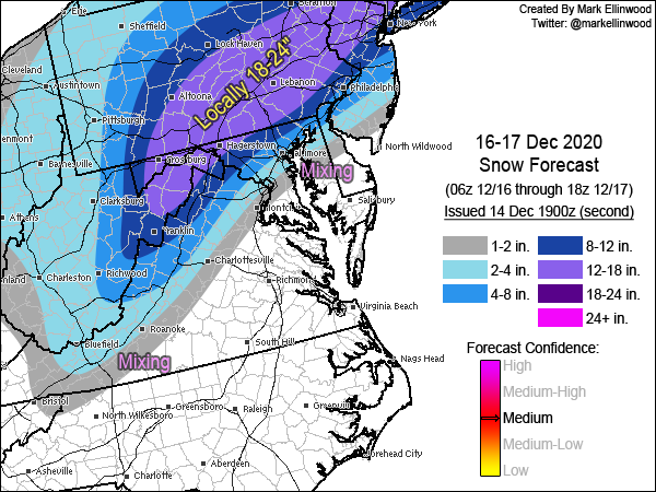
Good map, highlights the right areas
-
18 minutes ago, ravensrule said:
Thank you for explaining it to me like the weenie that i am. I pray that you are wrong but know that you are probably right.
I hope I’m wrong too. Nobody, not even the Mets like seeing double digit runs vanish with a puff like that.
-
4
-
-
Just now, ravensrule said:
That's fine and you will most likely be correct, but why not just write that it's a hunch then?. Either way it's great to have you back and posting. Hopefully we will be seeing a lot of you this winter.
Had password issues and couldn’t get back in the system. Got it worked out. The biggest factor for me is the 500mb pattern. It’s vigorous but it’s progressive, not cutoff, and not much phasing at our latitude. That won’t drive the cold air in, high retreats so source is gone. My hunch/guess on that is we don’t score like we want to.
-
2 minutes ago, mattie g said:
A majority of of us have been completely starved of snow the last couple years. Analysis is fine and all, but when you've been fighting for scraps for 1000 days, you start thinking that a steaming pile of sh*t looks appetizing.
Besides, most of us don't really know all that much about the science behind it - we're just fans of fun weather.
I feel you 100%. I want the snow too.
-
3
-


December 16/17 Winter Event
in Mid Atlantic
Posted
If you somehow avoid the sleet transition I think you can see 12+.