
ers-wxman1
-
Posts
2,481 -
Joined
-
Last visited
Content Type
Profiles
Blogs
Forums
American Weather
Media Demo
Store
Gallery
Posts posted by ers-wxman1
-
-
18z NAM is a disaster for the central and eastern sections. Decent front end thump then quickly over to sleet then heavy rain in all but favored locations...81/15/68/north of 70. Plain rain all the way past IAD this run. Wraparound snow changeover with CAA as the low goes east. CAD wedge is thin and marginal, quick retreat with WAA. Those near the M/D line into southern PA to I-81 will love this run. 12-18+ for those areas.
-
 1
1
-
-
16 minutes ago, MillvilleWx said:
He doesn't. That's why the Euro/GFS combo is still my top choice for outside 36 hrs in forecasting. They each have their biases, but GFS has numerically performed very well over the past 6 months.
It handled several land falling tropical systems quite well.
-
1
-
-
5 minutes ago, Ellinwood said:
Updated my snow map... cut down on the total on the eastern gradient (mainly DC up I-95 and through southern and central NJ). Increased totals along the Appalachians.
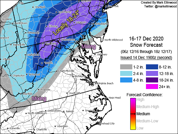
Good map, highlights the right areas
-
18 minutes ago, ravensrule said:
Thank you for explaining it to me like the weenie that i am. I pray that you are wrong but know that you are probably right.
I hope I’m wrong too. Nobody, not even the Mets like seeing double digit runs vanish with a puff like that.
-
4
-
-
Just now, ravensrule said:
That's fine and you will most likely be correct, but why not just write that it's a hunch then?. Either way it's great to have you back and posting. Hopefully we will be seeing a lot of you this winter.
Had password issues and couldn’t get back in the system. Got it worked out. The biggest factor for me is the 500mb pattern. It’s vigorous but it’s progressive, not cutoff, and not much phasing at our latitude. That won’t drive the cold air in, high retreats so source is gone. My hunch/guess on that is we don’t score like we want to.
-
2 minutes ago, mattie g said:
A majority of of us have been completely starved of snow the last couple years. Analysis is fine and all, but when you've been fighting for scraps for 1000 days, you start thinking that a steaming pile of sh*t looks appetizing.
Besides, most of us don't really know all that much about the science behind it - we're just fans of fun weather.
I feel you 100%. I want the snow too.
-
3
-
-
5 minutes ago, ravensrule said:
Can i ask you a stupid question?. I obviously am aware that you know 2,000 times the amount of me about meteorology but how can you be a thousand percent sure that the models won't shift SE in the next 24 hours?. You came off as if this is written in stone.
Sometimes I just have a hunch. Can’t explain it.
-
 4
4
-
 1
1
-
-
1 minute ago, ravensrule said:
That would still give me between 7-8". It would be by far my biggest storm in 4 years. I don't understand all the negativity.
It’s not negativity it’s an analysis. I know I haven’t posted in here much in the past year, but there used to be some good analysis and debates, now it just seems like a wish cast for snow and trying to hug all the models that give the most snow vs not relying so much on the guidance and more toward the actual synoptic features in play. What happened to all the key posters in here?
-
1
-
-
Same features at play, low track near the Bay, retreating High with marginal cold air eroding with strong e-se flow aloft off a 50F Atlantic into temps in the mid 30s? Not a screamer for a winter storm in my opinion. No way we see 10:1 ratios in the immediate suburbs. Shave euro numbers in half and that would be closer to reality.
-
6 minutes ago, Scraff said:
Do I have to sign in blood for the Euro?

ETA: Everyone feeling a little better now?
Same setup, not much to feel better about.
-
1
-
3
-
 1
1
-
-
16 minutes ago, Amped said:
Also WTF is wrong with the GFS?
Numerous upgrades over the years, with little or no improvement in forecasting skill in the months after the upgrade.
NAM is still the laughing stock, but GFS is providing plenty of extra comic relief this storm.
Do you have research and results in hand to back this up scientifically?
-
15 minutes ago, leesburg 04 said:
Well then I guess my emotion detector is off. Good luck with your forecast and stay safe
There was no ill will intended at all.
-
3 minutes ago, leesburg 04 said:
Just a tad too much emotion if i'm being honest but I'm sure you have a handle on this thing at this point
I leave emotion out of the forecast. I’m helping emergency managers make decisions so must remove emotion and put analysis and facts on the table.no emotion in my post, just facts.
-
7 minutes ago, leesburg 04 said:
damn dude that's harsh
Its reality.
-
 1
1
-
-
1 minute ago, leesburg 04 said:
damn dude that's harsh
Could see 3-6/4-8 for Leesburg but no way are we seeing 12-18 digital fantasy. Take it, D.C. gets C-1 then heavy rain with temps in the 40s.
-
2
-
-
Just now, chris21 said:
No snow on the backside?
Wet snow with temps in the mid 30s, hardly much to get excited about if you are not in those favored areas.
-
Not much left to go on with this one. Euro will come in line with the other guidance. 500 pattern is another clue...a few days ago it showed the H5 low closing off and deepening coming across, now it’s just a progressive vigorous wave that gets going too late, no phasing where we need it then sweeps OTS. Cold high pushes out faster and we are left with screaming E-SE flow aloft which even in a strong CAA setup would make things tough. Marginal setup such as this nails the coffin shut. I-95, cities all rain, few flakes to start. You will have to go well west and north for anything substantial...I-81, 15, 68, north of 70 to the M/D line. Perhaps advisory level to IAD, but mix to rain even there.
-
1
-
1
-
1
-
-
3 minutes ago, wxtrix said:
i’m in the mauling zone and i’m still tossing the NAM at this point.
If you are in Winchester you’ll have no worries regardless.
-
3
-
-
A lot of wishcasting going on in here. If the NAM showed a mauling for the area you would all accept it, but because it is not, it’s out of its wheel house and should be tossed. No, it should not be tossed! It is giving you hints as to the evolution of the pattern.
For one, the airmass regardless of the High setup is marginal at best! It is a CAD but not impressive and not Insitu. The low track is not ideal. This has been screaming fast changeover for the cities for days and even the immediate suburbs will mix or changeover. This is an I-81 to 68, 15 from northern Loudoun to the PA border, north of I-70 heavy snow event. Rest of us from west to east mix and even go to rain closer in toward Fairfax. Writing has been on the wall for three days.
-
11
-
3
-
2
-
1
-
-
1 hour ago, WxWatcher007 said:
Happy last month of met winter, weenies!


Time to bust out the shorts and tank tops. You’ll have to go to Mount Washington to find meaningful snow in that pattern.
-
Winter Fail 2020
-
That’s all she wrote folks. This Met is officially out for the 2020 winter. Just hoping the spring won’t be ruined when the NAO/AO eventually go negative.
-
1
-
1
-
-
It is likely the Mid Atlantic region will remain locked in this pattern right through February, possibly even March. Cold air will remain locked to our north with only a few brief and minor breakaways into the area, yet short lived. It’s not just this area, the Northeast, southern New England are all in the same boat. Even lake effect has been below normal. DCA may not even break 1”. Eventually the NAO/AO will come around in time to ruin our spring.
-
7
-
-
Geez Louise! This forum is even making me look like a positive person. It’s disappointing for sure, but it’s SNOW!! It falls, it sticks, it melts. Just had a good friends father rushed to the ER for 5 hour open heart surgery for aortic dissection. Nearly lost him on the table. There are greater tragedies in life.
-
2
-
1
-
December 16/17 Winter Event
in Mid Atlantic
Posted
Ok I’ve had just about enough posting in this place. No wonder you can’t retain any real meteorologists here.