

showmethesnow
-
Posts
7,250 -
Joined
-
Last visited
Content Type
Profiles
Blogs
Forums
American Weather
Media Demo
Store
Gallery
Everything posted by showmethesnow
-
Everyone? You mean maybe some were? I know I was no where close to canceling anything especially considering we were in early January. Been at this too long to get caught up in all the hype (both good and bad) we see sometimes.
-
Bigger storms all the way. And this isn't so much because I am big game hunting, which I always am , but more so because I think the odds are better if we go that route. Right now from what I am seeing on the models the trough positioning looks to set up a little too far east for progressive systems and I have a fear that if we don't see some form of blocking to slow the flow we will run the risk of seeing systems suppressed as they run to our south (Congrats S VA/N Carolina). But on the other hand the trough positioning is pretty much primo for systems if they amplify which we would see with blocking. And I don't necessarily believe it would be a one shot and we are done deal to boot. Could be a case of one system amplifying and nailing us and then providing a transient 50/50 for a follow up. And seeing as the models at this time are suggestive of this general setup being locked in for awhile beyond the end of the extended it would provide potentially a wide window to score when we could possibly be talking transient blocking. So Big Dog all the way as far as I am concerned.
-
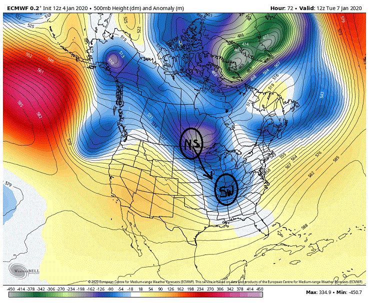
Yeah. So besides the obvious, trough/closed low undercutting ridging, you can also get split flow setting up when you start seeing large gaps between height lines.
-
Thought I would add something. PSU threw out analogs out the other day that weren't promising for our snow chances as far as a -EPO/+PNA combo. Good reason for that as that pretty much overwhelms the flow throwing a deep trough into the eastern portion of the country. This look is not what he is referring to though. Now this look above would clock in as a -EPO and a fairly strong +PNA. This is where looking at indices alone can be misleading. What we actually have is a -EPO and a very strong northern based +PNA. If you notice to the south we are seeing a flat flow with hints of a split flow and southern stream involvement. This is actually not a bad look at all if we can get some backing of the flow in the east (believe PSU mentioned this as well on his analog post about needing blocking up top) otherwise we are looking at progressive systems.
-
That look is more favorable for SS interaction. Up in the PAC west/EPO region we really aren't seeing much of a split of the flows as the distance between the height lines are staying uniform.
-
Really am starting to like the potential of what we are seeing beyond day 10 on the models. And beyond the end of the extended as well as this has the looks of something that could setup for a time. Will pretty much be dependent on if we can get something to slow the flow in the east (NAO/50/50). We see that and I think we are ripe for a fun time.
-
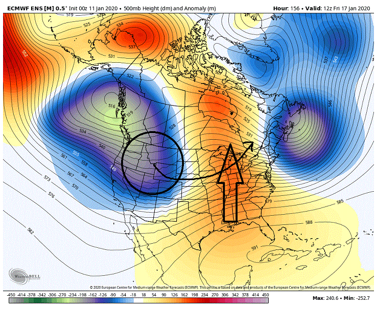
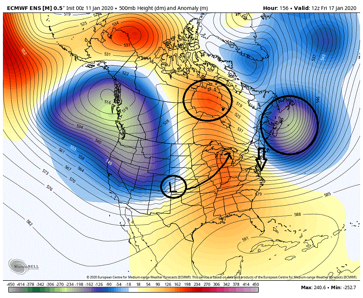
Another area we might want to keep an eye on is what we see in the PAC NW. Think given the current setup in the longer range this has better odds of producing then from the weak split flow showing up off the SW coast. What we are seeing is a split flow up over the EPO ridge with the NS and this is being undercut into the PAC NW by the PAC stream. With the troughing/piece of pv to the west providing ample energy to both streams. Given the current setup with a fairly aggressive trough in the east this is actually a good look for potential..
-
My initial glance at the EPS leading into our potential storm for next weekend was pretty much a, 'Oh crap' moment. Stronger height builds and ridging in front of our incoming system compared to the 12z and we were also seeing the NS with a weaker dig and a farther west track on its eastward movement. Height builds were pretty much suggestive of more warming leading into the system . As far as the NS track it pretty much takes the low running through our region or to our south off the table. As I said, it was a, 'Oh crap' moment. But diving into it a little bit and I realized it was actually a more promising look for frozen through our our region. What I didn't initially pick up on was that we were seeing much stronger height builds over top around the Hudson Bay which was translating to stronger higher pressures on the surface in Canada. We were also seeing the a stronger, slower and farther SE signature on the 500's through the 50/50 region. This setup is actually a fairly decent upgrade from the 12Z for maintaining CAD (cold air damming) in the east. One other thing, with the farther west track of our surface low the stronger southerly flow at the lower levels also shifts farther west making it that much more difficult to scour out the CAD. And below you can see the surface representation 12 hours later when precip is starting of what the 500's above produced. Strong high over top with a 50/50 helping to slow it down. This combo is producing a strong CAD signature east of the Aps. Farther west low is keeping the stronger southerly surface flow west of the Aps. Not surprisingly we saw an increase on the snowfall maps (looking at them more so for the frozen potential then for actual snow). The run was actually close to an all frozen event (snow, sleet, freezing rain) for N and W of the cities. Throw in a little better temps in the lower levels for after we lose the mids and we are talking Fz rain or sleet to end this.
-
I'm all.... At least until tomorrow.
-
Pretty good signal for being 12 days out for the 22'nd.
-
After just looking over the EPS I think I will jump on the Bus as well. Ignoring anything beforehand, day 10-15 looks very good. And as the pattern looks as if it is setting in one would have to believe that look extends a good deal beyond day 15. Good times. At least until the next run.
-
Speak for yourself. As PSU would say, Move north young man, move north. Think this may be why we are seeing the GEFS having issues with the weekend. It isn't sure what it wants to do Thursday as of yet.
-
Don't look now but some of the things I am seeing have me wondering if the GEFS is considering trying to bring something up from the south as the cold front pushes through on Thursday.
-
Was a decent look but I am not sure how much I trust the GEFS at this time. It is all over the place with the timing the last few runs.
-
I liked what I was seeing on the EPS. Seeing the changes we need to see and a move in the right direction for more frozen. As far as the GEFS, it is still in flux with what it wants to do. So for now I am riding the EPS.
-
Probably would worry more about what the ensembles saw and from what I see they were a win. Less emphasis with a cutter into the lakes and more emphasis with forcing low pressure to the East. Seeing better High Pressure over top the storm (more of a banana high). Also like the 50/50 low positioning better as well. eta: My bad, actually was only referring to the EPS.
-
I can live with this look in the extended on the EPS. Very workable pattern and is a tremendous upgrade to what we expecting to see just a week ago. The GEFS though is still somewhat rough as it continues to be heavy handed with the troughing into the SW and off the coast. But even that is workable towards the end of the extended though it would probably more so favor 40 north at this time.
-
<shrug> Not much to say. It pays well.
-
The setup for Tues actually isn't far from being a stronger storm then currently depicted. Right now the shortwave in the NS is lagging behind the southern SW. But a quicker, deeper drop with this NS shortwave puts it in a prime position for dropping down the back side of the southern for a phase. Only problem with seeing that occur though is that the low is struggling to stay south of us as it is. Stronger system and we are tempting fate on seeing the system run to our west. So the question is, do we fell lucky?
-
And lots of beer. Right now there is pretty good potential for those north of the boundary to do very well with the projected look (right now we are probably talking central/northern PA and northward). The question is, can we see that shifted southward enough for our needs. With how hostile the PAC is about the only quick fix I see possible to doing this is to see the pv displaced S/SEward by quite a bit as I posted above. Do I expect to see that? No, not really. But it doesn't mean I won't be rooting for that Scan ridging to start popping on future runs.
-
An op run so this isn't really worth much, BUT DAMN... And here I thought I was the optimistic one. You are a better man then me if you can see positives out of this.
-
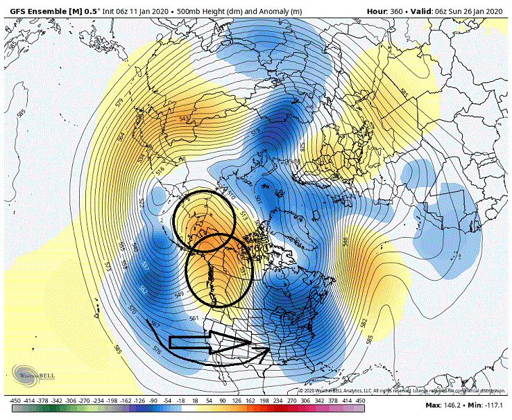
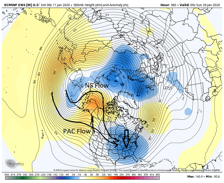
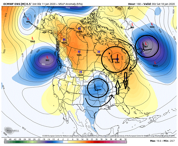
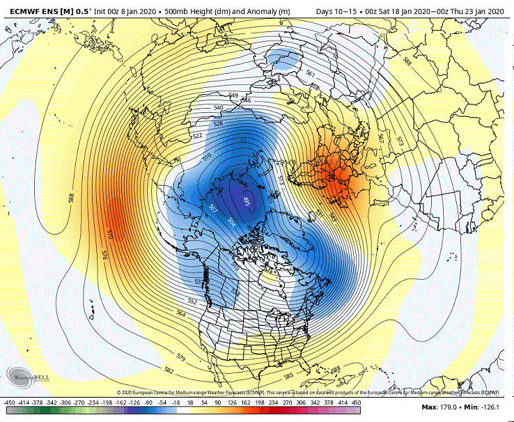
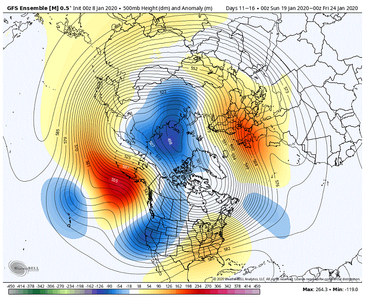
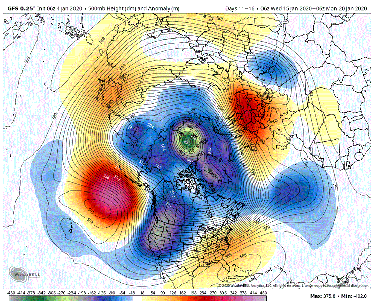
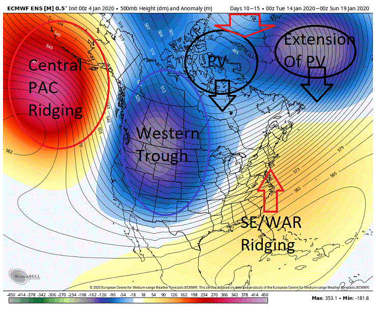
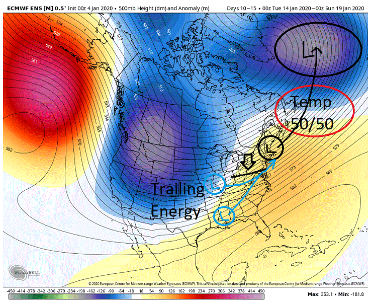
I know many are seeing this 10-15 day ESP map and saying 'Oh Crap', I know I am though my comments are more of the R-rated nature. With very strong indications that the central PAC ridging and the Western trough will be semi permanent features for the foreseeable future it doesn't bode well for our chances as we see the heights pumped up in the east. ***GEFS is similar though the major features (PAC ridging, Western trough, Eastern ridging, extension of the pv) are shifted a little to the west.*** Our hopes at this point reside in what we are seeing around the NAO domain to hopefully trump the extremely hostile PAC. Right now what we have is the PV planted in the western NAO domain with it extending to the SE of Greenland. We are also seeing ridging nosing into Greenland. Now this look doesn't particularly give me the warm and fuzzys on trumping anything though I do see some indications that we could possibly work with this as well (I will explain later in that regard.). BUT..... throw stronger ridging and height builds into Greenland, the stronger the better, and it is possibly a different story. We see this and we should see the pv respond by dropping farther south dragging the extension of it along with it. Now the effects of shifting of the PV feature southward is two fold. First the PV placement farther south will help knock down the heights in the east dragging the mean boundary (cold air) south along with it. 2nd we would hopefully see the extension of the PV shifted to the south as well into the general 50/50 region which would imply a semi permanent 50/50 low in that region. This would favor amplification of the wave lengths/lows in a favorable location for our general region. Now a slight shift south just will not cut it for us. I am talking a somewhat major shift (central Hudson Bay region latitude), give us this and I would feel much better about our chances. Now though I would prefer the above scenario to play out given the hostile PAC (much better odds) I do see the possibilities given the above look presented at this time. What we are seeing on the models through the day 10-15 period is that they are driving storms through the 50/50 region on their way to the semi permanent low planted SE of Greenland which is key. Behind these lows the boundary gets dragged southward hopefully putting it in a favorable position for our region for any possible follow up energy.. And though the SS looks fairly dead at this time (wouldn't rule it out as of yet) we are still seeing quite a bit of energy in the mid-Latitude flow. At this time the flow/setup would favor seeing amplification of trailing systems, it would just be a matter of where we see this occur and that comes all down to timing/distance between the lead temp 50/50 low and the trailing low (otherwise we will see the boundary pull northward again as the SE ridging exerts itself once again). Were talking a more thread the needle type scenario vs the above example so we are talking lower odds. At this time both the GEFS and the EPS have fairly strong indications of this exact scenario playing out around roughly day 12 in roughly a favorable location for our locale. (I hope I don't have to repeat the usual disclaimers of talking about something that is 12 days out). So anyway, I guess what I am saying is, don'tgive up quite yet. There are still possibilities despite what the models are throwing at us.
-
The look at the end of the extended on the GEFS isn't too bad for central PA northward. Too bad we are south of there.
-
All jokes aside, I probably favor this running through or just to the west of our region at this time. But 4 days so let's see where it goes.
-
Really can't say anything because of my God like powers when it comes to my posting about our snow chances but I will say, 'The squirrel is digging for the nut'.


