

DocATL
-
Posts
931 -
Joined
-
Last visited
Content Type
Profiles
Blogs
Forums
American Weather
Media Demo
Store
Gallery
Posts posted by DocATL
-
-
I wouldn’t get too excited about the system for next week. That’s a rainmaker.
-
What an epic amazing storm. We may not see this again until next year.
-
Easily would trade the reliable turd duster tundra for the occasional Atlantic-fueled Miller monster. No brainer.
.-
 3
3
-
-
Can’t wait for things to green up.
.-
1
-
-
A reminder of what rippage looks like for y’all.
Needed that. Early December was a lifetime ago. Thanks for sharing.
.-
 1
1
-
-
no but we'll get fucked in april
Noooo that will suck. Wish we could just go beast mode and then be done with it. Oh well.
. -
Euro weeklies warm to normal…do we make our 6.6” snowfall average for March?

. -
At least the models figured this out outside of 48 hrs, could have been worse!
.-
1
-
 2
2
-
-
Not even close. East coast storms and rumors of storms bust all the type.
Oh for sure…just some notable events THIS year have transpired that way. Recency bias of course.-
2
-
-
Back in the day (oh God im sounding so old).....the boards were more full than they are now. And there was always an odd fixation with the east coast. But it was ONLY when they would get a noreaster. Its one thing to be interested in a storm, but the fixation was lingering, even when a majority of the time they would not see winter weather. All around winter is superior here, the ceiling for storm potential superior there. Should be easy to understand.
Big dog potential always gets folks excited. The nickels and dimes less so…but definitely more snow-covered days so there’s that.-
1
-
-
reality shall set you free.
So will dense ranking but t’is the Olympic season so fine. 11th still is pretty remarkable.
. -
Idk how that ended up feeling like it's the status quo lately but it's tough fs
Feels like it’s been the case for us in the western GL’s. Meanwhile, southern snows and coastal miller B’s are showing up at hour 300 and locking in.
. -
-
Euro stinks. GFS is king.
Euro will reclaim its throne!
. -
It’s not.
We’re out of the top 10 now.
Tied for 7th!!!
https://www.weather.gov/lot/chicago_feb_snow_rankings
I’m petty. -
Euro says why the hell did you start this thread?
. -
X posting my 2.1 final call
Fortune favors the bold.
. -
Wow, banger February
Still a top 10 least snowy Feb…we’ll see if the Thursday system doesn’t go south.
. -
The fixation on the east coast is wild because it's so one sided. 80% of their winters are zzzz. In fact....they just had a historic snow drought so a historic storm is a perfect middle finger to a few on the main weather forum who acted like it would never snow in NYC again. Feast and famine climate will get the occasional feast.
I think the fixation is more about what’s happening this winter.
. -
5% probs lol.
you’re too fixated with the east coast. Should move there.
I mean they’re about to get 2 feet in like 12 hours. It’s kind of a big deal.
.-
1
-
-
But you promised it was going to be a Southern WI banger.
There’s still time and more opportunities for a Wisconsin banger!
. -
That'd be nice but I'd be happy with a 2" event at this point. Only had two 2"+ events this winter (Nov 30 and Dec 7), the rest have all been sub 2 inchers lol. Actually most have been sub 1 inchers.
Euro 12z suppressed and weaker for the mid week event.
.-
1
-
-
Anything measurable at ORD last night?
. -
I'll allow it.
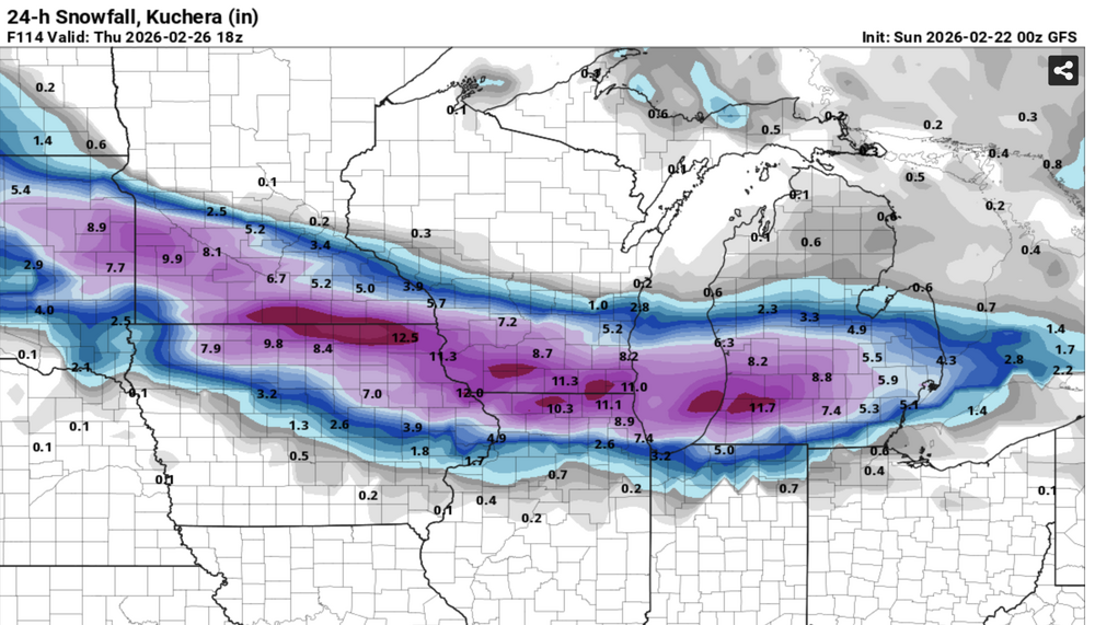
Probably tracks a bit further north. A good hit for southern Wisconsin.
.


Winter 2025-26 Medium/Long Range Discussion
in Lakes/Ohio Valley
Posted
Well it was either going north or south, right?
.