DocATL
-
Posts
574 -
Joined
-
Last visited
Content Type
Profiles
Blogs
Forums
American Weather
Media Demo
Store
Gallery
Posts posted by DocATL
-
-
Mine is the 16th
.-
 1
1
-
-
Event on 13th looks like it's not a mirage, not a major but it's a start
Got to proceed with caution until the afternoon of the 12th.-
 3
3
-
-
I was in Miami in January…it was an A+.
-
 1
1
-
 2
2
-
-
Anyways…the Euro looks nice.
. -
Hold…hold…hooooold…
-
 1
1
-
-
Don’t be dense. They were obviously carrying it through today with no snow expected. The claim is true through today’s date. It should have stated that was projected through the 7th, although that context was probably provided on air or on the web where this X account pulled the graphic.
Yes, it was pulled from WGN but I wasn’t sure about its veracity. -
https://x.com/nilwxreports/status/1887692504331432224?s=46
Is this true?? If so that’s nuts! -
Could you please expand on your thoughts for the upcoming pattern
Preferably a long form video with graphics.
-
 2
2
-
 1
1
-
-
MBY still has not caught up to Pensacola's season snow total...
#Goals -
The ensembles are as active as they have been at any point all winter heading into the next few weeks. Something good better come out of it!
Or more opportunity for suppression to the south and late phasing to our east. I do think Michigan (including Detroit) will get a good hit.
.-
 1
1
-
 1
1
-
-
Just about two weeks away from the end of malackalogical winter, so either we get a nw trend sometime next week or
The NW trend has been mythical this year.-
 2
2
-
-
I honestly wish we were on the warm side of the SER with some sunshine. It would make this all much more tolerable.
-
 1
1
-
-
ive noticed this over the years too...people think that other areas have consistent modeling. They dont. They have had countless fantasy storms in the northeast. The upcoming pattern is very active on the ensembles for the northeast although our sub (especially eastern sub) should get some fun too.
Yeah…usually with the coastals and walking the line between snow and rain. It just seems wild how with this current set up they are locked in and we are all over the place. -
March will be magnificent for northern Illinois and Iowa 🫠
. -
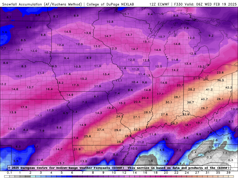
I know some of us hate it when we post OP runs but the 12z Euro is too good not to post.

Well just skip the 00z GFS, then. -
Trying to understand why mid range modeling is so all over the place for us from run to run while the mid Atlantic and northeast have a consistent signal for snow. Is it phasing or trough position?
. -
Slick out here in Naperville. Caught a few patches of ice on “treated surfaces” driving my son home from basketball practice.
Apparently some bad wrecks to our west. -
2/7-2/8 is looking like a good hit for MSP. GFS and Euro both in agreement with 0.50”+ of precipitation and SLRs of 15:1-20:1. I’d start a thread but it would be an echo chamber of me. Time to get the powder skis waxed.
MSP well overdue for a good hit.
.-
 1
1
-
-
Wrong forum.
You’ll be ok, I promise.-
 3
3
-
 1
1
-
-
Corrected your statement.
Good catch!
Someone on the east coast is likely to get a nice wallop though. -
Nope.
2 feet in central Virginia is most certainly wild. It might be completely different with the next run though. -
OP GFS wildin’

-
 2
2
-
-
I work right by a window looking out into my backyard. The yard is now frozen brown/yellow/pale green grass with a few snow piles and I am always reminded how much I HATE looking at bare ground after a prolonged period of snowcover, even not deep. I mean, it sucks anytime, but its less of an "ugh" factor when you have only had snowcover for a few days.
Yes my yard looks awful. These next two ice storms will keep our ground ugly but maybe we cover it up again after that.
. -
Mid 30’s all day in Chicago burbs. Kinda just raw and uncomfortable.
.

2/12 Winter Storm
in Lakes/Ohio Valley
Posted
Or take it down from eBay
.