

DocATL
-
Posts
202 -
Joined
-
Last visited
Content Type
Profiles
Blogs
Forums
American Weather
Media Demo
Store
Gallery
Posts posted by DocATL
-
-
I’d expect the warnings to be lifted for the Chicago area this afternoon.
. -
I'll take what you're selling gladly but I'm a little skeptical of much accumulation later
I fully agree. Much of Chicago metro Is done per the HRR. Looks like we get some wrap around overnight but the low rapidly lifts northeast by then. I’d guess maybe an inch of additional accumulation at most per the HRR. Looks like the NAM from 24 hours ago was spot on.
.-
 1
1
-
-
This trough feature extending from the main SLP is an interesting development that we've seen gain traction over the past 12-24 hours.
It can enhance precip/snowfall. Folks in the Northeast see significant versions, Norlun troughs, that sort of do the same.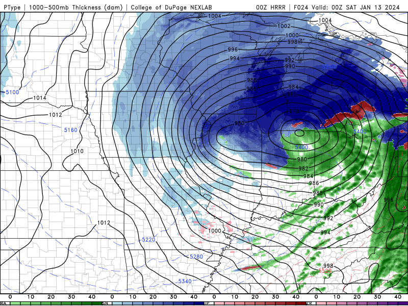
Looks like a nor’easter bombing out over the New England coast.
. -
How does the 12Z Euro look especially for Chicago ? Is it similar to the 12z gfs?
Bullseye for central and north metro.
.-
1
-
-
NAM is trash.
. -
If the NAM and long range HRRR and RAP are the only models not showing high totals then that's a good thing. Looks like globals and even HRDPS and FV3 really hammering most of NIL with heavy snow.
FV3 was equally as good lower expectations for the Monday/Tuesday system.
. -
Why does NWS Chicago say this:
“The
forecast for this storm system continues to be handled best by
the more consistent global forecast models and ensembles
(especially the ECMWF and its ensemble members). We therefore
continue to steer the forecast in this direction. Currently, many
of the higher resolution models such as the HRRR, NAM and RAP
continue to be northern and warm outliers with the system, and
thus, their current iterations are not favored.”
By handled best, do they mean most consistent in terms of forecast?
. -
Unfortunately surface temps stink again for this one which is gonna take a chunk out of accumulations.
. -
So what you're saying is that we all need to dump bags of ice into the lake?
Probably still not enough 🫤
. -
Crazy how the lake I assume can reduce amounts and then you go just west a little and you are at 10 inches. That sucks for us near the shore or in downtown. Is there anyway that the shore or downtown can get in that 10 inch range ?
Rapid cooling of Lake Michigan
. -
For being the gold standard of mesoscale models,the NAM’s run to run variability is ridiculous.
. -
The FV3 was pretty good with Monday/Tuesday event and it’s still looking ok. Nothing epic since 10:1 is overdoing it but I’d guess advisory level.
. -
Euro flirts with same marginal temps and we likely have some rain in the south side of Chicago but otherwise it looks juicy.
. -
It appears the pivot will attempt to happen right over the metro area.
Yeah…intense DZ bands basically parking themselves over the metro.
. -
Ripping in Naperville. This second round going to be a winner for west and northwest burbs.
.-
1
-
-
When I moved up here from Atlanta, my neighbor gifted me a snowblower. I now realize he was just trying to offload his.
.-
 5
5
-
-
The pattern change is already occurring, with additional evolution likely with time.
True…yes we are out of the ridiculously warm pattern.
. -
Ll
This is incomplete information. I would expect a pattern change but not until the end of January. We will have to get through the warm MJO phases. The PV likely goes to Europe as it seems that is the hot hand in recent years.
.-
1
-
-
The metro is out of the game most likely.
The occluding-stacked low is wrapping in a tongue of mild temps, enhanced by the mild lake.
Was just hoping for a miracle.
.-
1
-
-
Might be interesting tomorrow morning if our fetch here in Naperville is more NNE than NE.
.-
1
-
-
We may not be getting much snow in Chicagoland these days but this is about the thickest frost I’ve seen in my life!
. -
Surprisingly, the current record high minimum for today at ORD is 37*F (set in 2019). And I say surprisingly because 37*F does feel low (but that's just a hunch, I have nothing empirical to back that up with).
I doubt 52*F (or more specifically, 50*F at ORD) holds, but even several degrees lower than that would still shatter the record.
Record high minimum for Chicago was 46° and looks like we beat that barring a significant drop before midnight! We won’t beat the all time high of 64° unfortunately. What a time to be alive! Tempted to check if the hydrangeas are budding. Looks like I brought the south with me when I moved north!
-
Couldn't have said it better myself. Great post!! Pretty much in agreement with you.
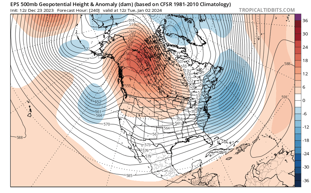
This type of evolution, with multiple troughs ejecting out of the west as the PNA trends negative...but with some sort of a PV over eastern Canada and a bit of downstream blocking, keeping things from cutting/amplifying too much...would bring at least some snow potential to the region January 4-10th or so...maybe lingering longer if the blocking can persist.
I feel like the change to more polar influence and some blocking (both in the northern Pacific and Atlantic IMO) are strongly supported by the larger-scale drivers (tropical forcing, mountain torque, stratosphere) as [mention=147]Chicago Storm[/mention]laid out. I don't think we'll get a great clipper pattern or persistent arctic air, which are the bread and butter of upper Midwest and Great Lakes snow climo, but some colder air and southern stream influence should bring trackable potentials at least.
Will be interesting for sure. It seems like Nina or Nino, the pacific jet continues to be the biggest influence on our weather. PV splits seem to not deliver up to the hype. But literally anything beats the current pattern. 52° right now in western suburbs of Chicago. Got to be a record high low.
. -
In the 2015 there was under and inch and in '21 there was just a few, but no solid brown like this since I've lived here.
Wow that’s epic! It’s funny. I’m in my first winter in the Midwest after 13 years in the south and it’s been a piece of cake!
.


Jan 11-13th Blizzard
in Lakes/Ohio Valley
Posted
Rain well north of Chicago now creeping towards the Wisconsin border. Lots of standing water now in Naperville. Definitely raises the concern for flash freezing as we get into tomorrow. A sheet of ice might be worse than a blizzard.
.