

PackGrad05
-
Posts
1,778 -
Joined
-
Last visited
Content Type
Profiles
Blogs
Forums
American Weather
Media Demo
Store
Gallery
Posts posted by PackGrad05
-
-
Finally more heavy snow near Fuquay!
-
 2
2
-
-
Just now, NorthHillsWx said:
Ouch…
Dusting of snow. All sleet now and some freezing rain
-
 1
1
-
-
We've had nothing but freezing/rain sleet in southern Wake near Fuquay for the past hour.
-
HRRR is dissipating the Thursday morning band...
However, it is extending the duration of precip from this first round tonight.
-
2
-
-
HRRR trends have definitely been to increase the western expanse of the precipitation and to build it back in for a slightly longer duration event.
-
HRRR continues to look good. Isn't as drastic as NAM
-
 1
1
-
-
The 01 and 02 HRRR is picking up on a really nice banding, especially southern Wake
-
1
-
-
Remember only one model is really showing that problem. HRRR doesn't look bad at all.
PLUS, this only affects initial moisture transport for the front end thump... Once the low spins up off the coast, moisture will easily feed back west.
-
2
-
-
Thursday morning could be better for the Triangle than Wednesday afternoon
-
5
-
-
Currently the NAM is the only one really showing it. and central NC still has 1-2 inches which is what most local mets are maxing out at anyway.
-
1
-
 1
1
-
-
Model is depicting loss of moisture from storms to south. Mike maze said he’s watching
.-
1
-
-
The convection would only impact moisture on the front end for foothills. Once the low spins up off the coast that’s when central nc gets most precipitation anyway
.-
3
-
 1
1
-
-
Mike maze just mentioned the storms blocking moisture transport
. -
I think RAL is too high for south wake. They should have kept their original dusting to one inch.
.-
1
-
 1
1
-
 1
1
-
-
Man, we really are back. I haven’t heard the convection robbing moisture argument in over four years. It does also depend on the orientation of the convection.
. -
HRRR looks really nice for central NC. Continues light precipitation into Thursday morning.
-
2
-
-
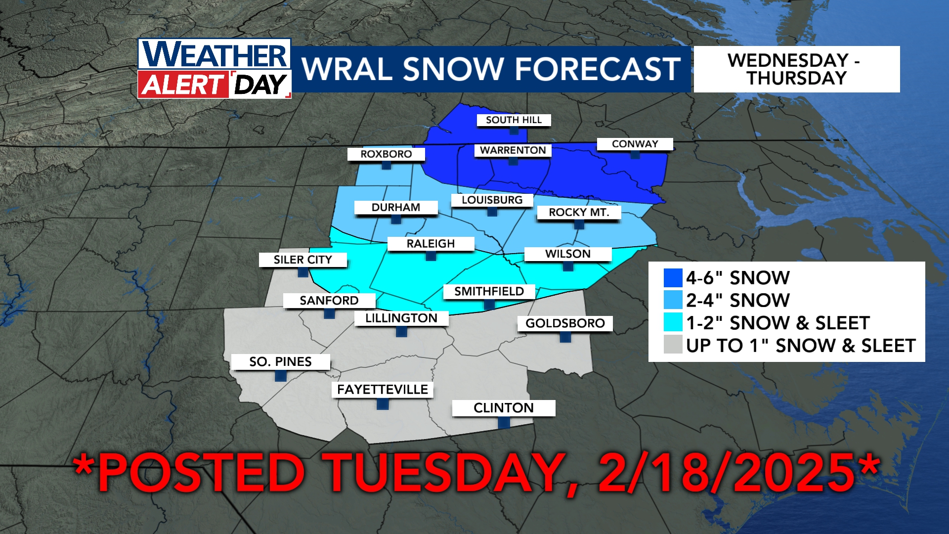
WRAL UPDATED MAPS
-
-
For Wake, looks like precipitation begins between 11-1.
-
Messaging during winter storms is so so difficult. Everyone I talk to here in Wake is latching on to "snow snow snow." There will be a lot of people tomorrow calling this a huge bust, even though scenarios and worst/best case scenarios have been explained ad nauseum.
-
2
-
-
The 12Z HRRR increased from the last run. It also showed light precip lasting until Thursday morning around sunrise.
-
1 minute ago, eyewall said:
Raleigh downgraded to an advisory for 1-3 snow/sleet.
Was it downgraded if it was never really a winter storm warning
-
3
-
 2
2
-
-
12Z HRRR is looking better
-
Really intrigued with the NAM and other models showing some light snow Thursday morning also.
February 19-20 Obs Thread
in Southeastern States
Posted
The last 20 minutes has absolutely ripped here in southern wake. We've gained an inch in just 20 minutes!!!