

high risk
-
Posts
2,908 -
Joined
-
Last visited
Content Type
Profiles
Blogs
Forums
American Weather
Media Demo
Store
Gallery
Posts posted by high risk
-
-
Southern MD about to get drowned.
-
 1
1
-
-
9 minutes ago, mappy said:
WBAL Mets are poo-pooing the warning being issued. Tony Pann and Tommy T
Yeah, there is some rotation, but it’s quite broad. But LWX is always nervous to miss something.
-
Some really weird boundary interaction must be supporting the rotation northeast of Baltimore, as the wind profile is almost as anti-supercell as you can get.
-
26 minutes ago, WxUSAF said:
Swing and a miss
Sorry - I stole your rain. 0.30” here.
-
2
-
-
5 hours ago, frd said:
Mount Holly has increased the probabilities of rain from 50 % to likely at 70% here on Monday.
The event on Monday plus Tuesday's storms has produced the days 1 to 3 rainfall, which has increased from the WPC.
We should hopefully score some rain, with possible severe on Tuesday, as you mentioned, then several summer days around 86 to 88.
I’m not seeing much of a signal in the CAMs to support a higher PoP tomorrow out your way, but I hope it works out for you.
-
1
-
-
2 hours ago, frd said:
What are your thoughts about Monday afternoon, regarding storms pushing East and through I-95 ?
Accu-weather is talking about Monday as robust storm chances, geater than 50 % then and then the the focus shifts to Tuesday for the severe parameters and likely higher end potential.
I'm not sure how much coverage there will be on Monday, but shear will be slightly improved (relative to today and tomorrow), and CAPE should be plentiful. It's probably a MRGL day with some potential for a late upgrade to a SLGT. A bigger threat might be localized flash flooding, with huge PW values and still relatively slow storm motion.
-
 3
3
-
-
1 hour ago, Eskimo Joe said:
Swing and a miss. Strike two!
If that 9pm cell missed you, it couldn't have been by much. Storms just blew up a bit east of me - getting occasional thunder here.
-
28 minutes ago, WxUSAF said:
Think it makes it to our latitude??
Something will probably make it us, but it will probably have weakened considerably. Sigh.
-
1 hour ago, Eskimo Joe said:
Line formed in Adams County and dropped into Carroll before dying near Westminster.
Seems to now be looking good for north-central MD. The HRRR, though, wants to weaken the storms with the loss of heating, so we’ll see how much can be maintained over the next couple of hours.
-
1
-
-
2 hours ago, high risk said:
There is modest consensus (it's far from unanimous) for a somewhat-organized line of storms to drop southeast out of southern PA towards sunset and into northern MD. A few solutions suggest that it could extend into more of central MD. Shear is crap, but low-level lapse rates are good, opening the door to a few wind reports, consistent with the SPC MRGL.
Beyond that, my eyes are on Tuesday. A strong front arrives at peak heating, with improving wind fields and some upper level support..
I should have noted that the ARW2 showed storms firing across northern VA this afternoon and spreading east. It was an outlier, but it may be on the right track.
-
4
-
-
There is modest consensus (it's far from unanimous) for a somewhat-organized line of storms to drop southeast out of southern PA towards sunset and into northern MD. A few solutions suggest that it could extend into more of central MD. Shear is crap, but low-level lapse rates are good, opening the door to a few wind reports, consistent with the SPC MRGL.
Beyond that, my eyes are on Tuesday. A strong front arrives at peak heating, with improving wind fields and some upper level support..
-
9
-
-
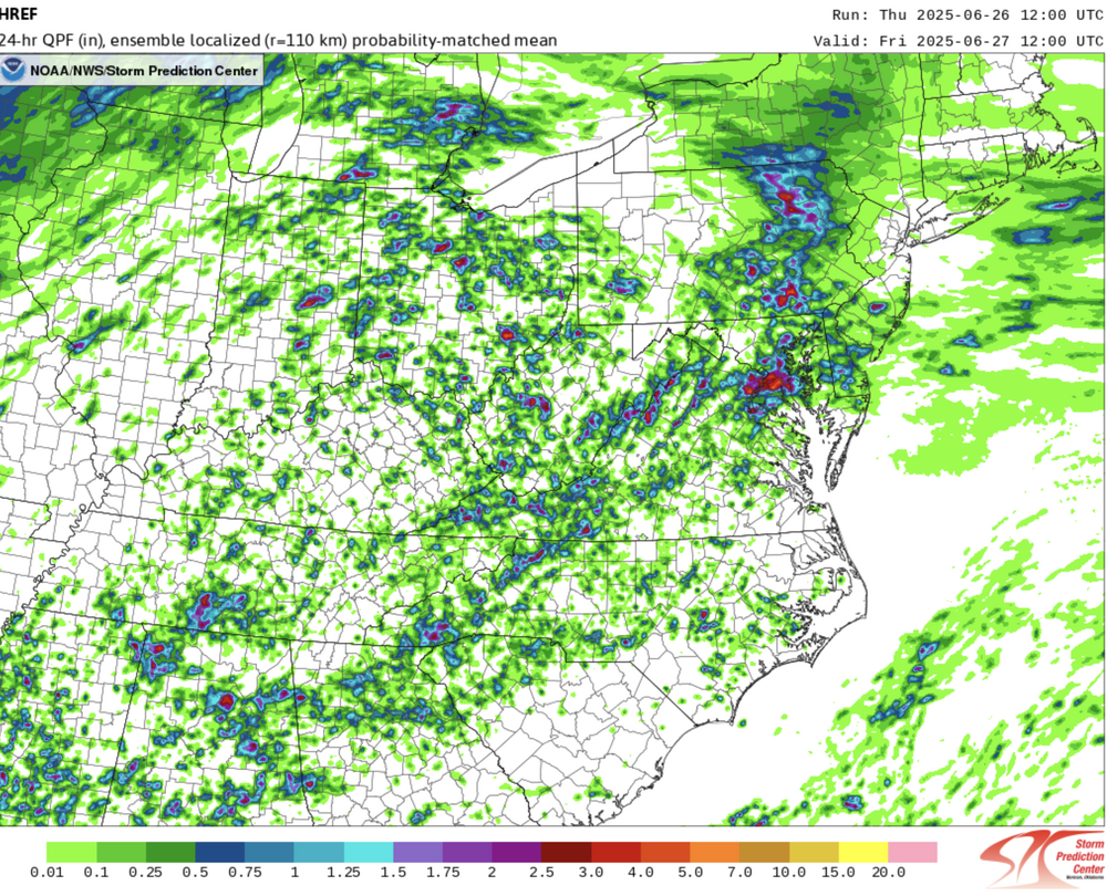
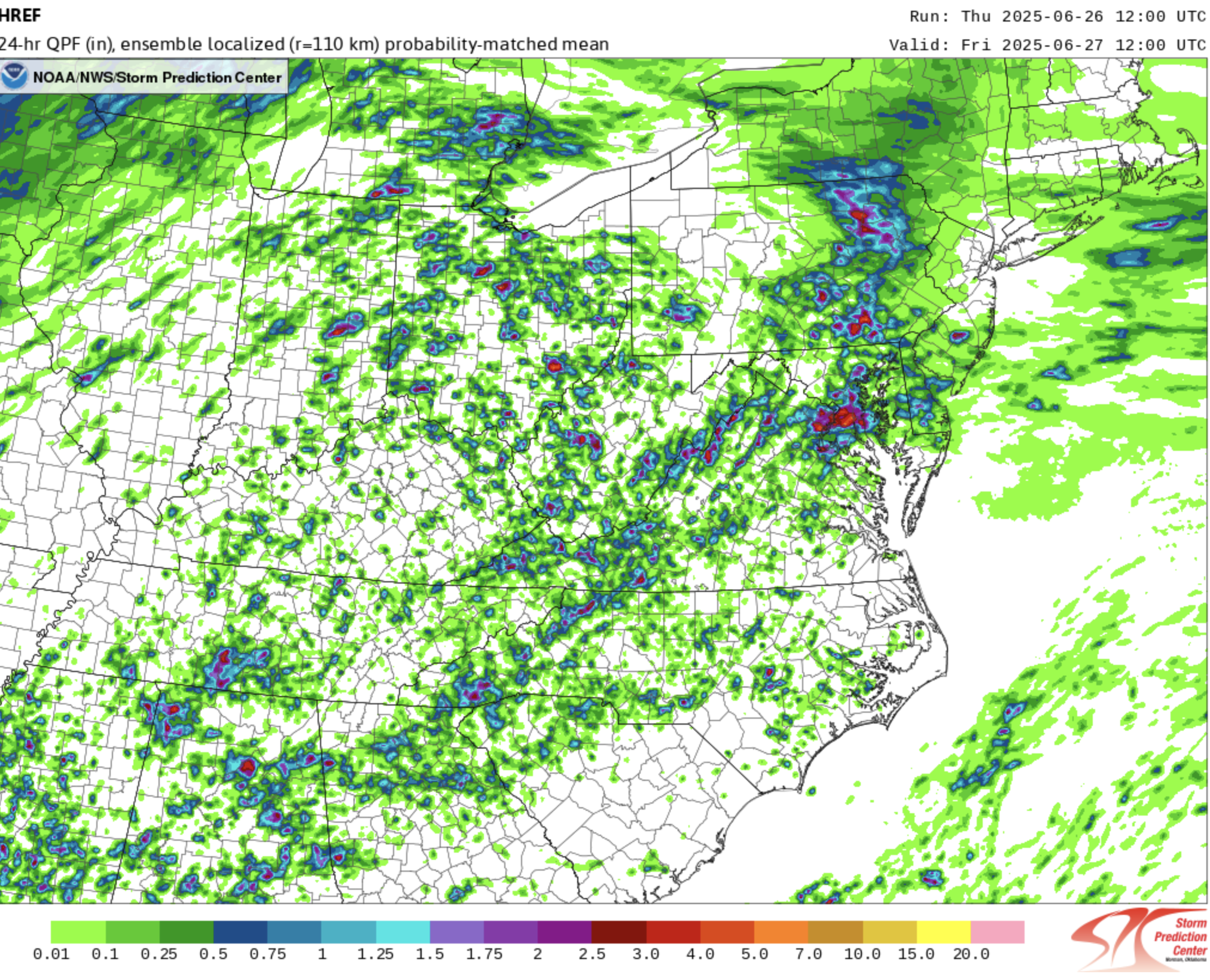
LWX issued their flood watch based at least partially on the HREF, which is going to end up doing very well highlighting the area of heaviest rain:
-
5
-
-
Big time blossoming of convection on the east side of DC.
-
1
-
-
5 hours ago, frd said:
That MCS is trending a bit more South recently. Interesting to watch for sure.
Yeah, that HiResW ARW run yesterday that brought storms into northeast MD this afternoon nailed it. They’re not severe, but I’m still curious to see how far to the southwest they can persist.
-
2
-
-
SPC removed us entirely from any threat today. I can’t argue with that, given that no guidance brings storms anywhere close to our area. That said, guidance has no real handle at all on that MCS.
-
3
-
-
I was not expecting to be in a MRGL tomorrow, and most CAMs show no threat to our area at all, *but* there is a scenario in which the MCS that move into upstate NY (and possibly northern New England) late tonight leaves an outflow boundary over northeast PA or central NY, and a new convective complex initiates there and races south-southwest. The idea is best represented by today's 12Z HiResW ARW and to a lesser extent by the HiResW ARW2. It's certainly not likely at this point, and even if it happened, it might die as it arrives, but there is certainly at least some small potential for a surprise event, especially for northeast MD.
-
5
-
1
-
-
Winds gusted to near severe limits here in southern Howard. The lightning is intense in the trailing stratiform rain.
-
1
-
-
The HRRR clobbers most of the area tomorrow, but the other CAMs are more scattered. It's consistent with SPC's concern that the cold front will be well to our west at peak heating, so the storms will have to form on the pre-frontal trough. That scenario can still work well here, but it justifies the hesitation (at least for now) to hold off on upgrading to ENH. Otherwise, I think it would be an ENH setup, and it still might be.
-
4
-
-
Just now, Kmlwx said:
PWS has already picked up 101 lightning strikes and counting. Sub-severe here but POURING and tons of thunder. Messy looking radar as well. Appetizer for tomorrow?
Yes, the higher-end severe threat is definitely tomorrow.
-
1
-
-
The Day 3 risk for Wednesday is a MRGL for the Eastern Shore and northeast MD, but evening guidance suggests that they will have to move it back tomorrow (as the new Day 2 outlook) to the west to include the DC/Baltimore area. Could even argue for a SLGT, but I'll wait until the 13Z outlook on Wednesday for that to be added.

-
1
-
-
WTF is this?
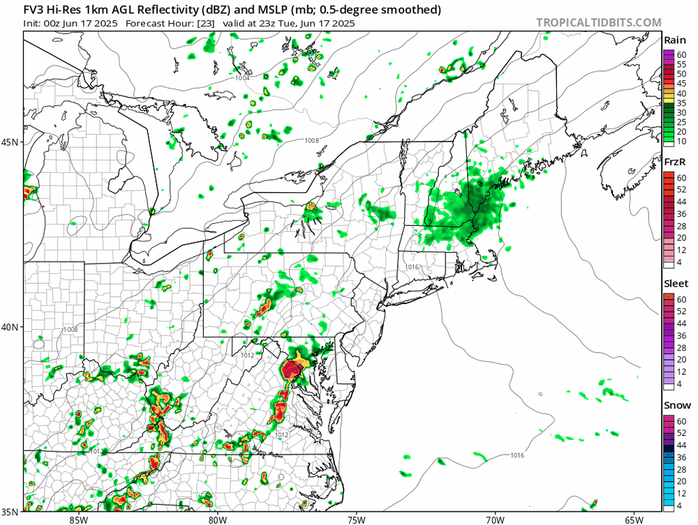
(It's just the FV3 doing its "huge storm" thing, but good lord.)
-
11 hours ago, SnowenOutThere said:
So would the storm mode mainly be pop-up microbursty stuff or a squall line?
We haven't done squall lines well at all in the Mid-Atlantic in recent years, but this setup certainly favors very organized intense convection. Pop-up stuff occurs with weak forcing, and the cold front arriving during peak heating (and it should plenty hot with high dew points) with a modestly strong upper level trough will provide strong forcing.
-
3
-
-
45 minutes ago, Eskimo Joe said:
Starting to see this on radar. Wonder if it's southeast flow interacting with Parrs Ridge?
Could be, or it could just be low-level speed convergence which is kind of hinted at on a few HRRR 850 mb images. Regardless, us Howard County folks look to be left out of the show again......
-
a number of recent HRRR runs break out an area of heavy precip over north-central and northern Maryland later this evening. It doesn't appear to be a northward propagation of the existing rainfall. Curious to see whether the HRRR is onto something.
-
3
-

July Discobs 2025
in Mid Atlantic
Posted
A bunch of consecutive HRRR runs have another round of convection overspreading the area towards dawn. The NAM Nest has a similar idea, although it's weaker with that batch and then a bit heavier with some mid-morning showers.
I've also heard various media forecasts promoting drier air for Wednesday afternoon, but a clear majority of guidance (minus the always overmixed GFS) keeps our dew points around 70 through Wednesday evening and doesn't really bring in the drier air until early Thursday. And several models show isolated convection just ahead of the front Wednesday evening.