

high risk
-
Posts
2,587 -
Joined
-
Last visited
Content Type
Profiles
Blogs
Forums
American Weather
Media Demo
Store
Gallery
Posts posted by high risk
-
-
2 hours ago, WxUSAF said:
Where’s the 0.5-1.5” of rain I was promised? Not even 0.1”… I’ll refrain from bumping the drought thread FOR NOW.
You might get it in 15 minutes with this line rolling through now....
But yeah, the models really backed off leading up to the event.
-
Hard not to be interested with a red box now up for areas just to the southwest, and the latest guidance showing a surge of instability ahead of the line segment. Overall, the CAMs show a weakening trend, and the hodographs aren't all that impressive, but I'll definitely be watching for a while longer.
-
 1
1
-
-
2 hours ago, Kmlwx said:
I was thinking the same thing after I read his message and then looked at the map lol
The environment certainly does look a bit more favorable later tonight than it had been, but I'm not seeing any decent UH tracks in any of the CAMs.
-
3
-
-
5 hours ago, yoda said:
SLGT risk moved into most of N VA and C MD on new Day 1 for 15 wind and 5 tornado
You have a VERY generous definition of "central".
")
-
 1
1
-
-
1 hour ago, Kmlwx said:
12z FV3 actually looks pretty good on sim reflectivity.
definitely the best solution, but somewhat on its own. Our best hope for SVR is focus in the early evening, as the potential for something if we have to wait later in the night is still fairly low, IMHO, despite some good wind fields
-
 1
1
-
-
No surprise that the tornado watch is for areas well south of DC.
-
3
-
-
While I'm modestly interested in Wednesday for areas south of DC, I'm actually intrigued a bit more (at least for those of us from DC to north) for Thursday. Cold temps aloft will allow for some surface-based instability to be present, and with very low freezing levels, I think that some hail/graupel is likely with the stronger cells. Downdraft CAPE is also present, meaning that some stronger gusts are possible too. All of the CAMs have a good convective signal. Maybe it won't quite require a MRGL, but it sure looks like an interesting afternoon.
-
5
-
-
2 hours ago, yoda said:
When you say low-level warm air, is that related to or correlate with the warm front? Or is it something different?
The surface warm front is the leading edge of that warmer air head trying to return to the north.
-
1
-
2
-
-
Wednesday is pretty interesting. The shear will be off of the charts, and wind damage and tornadoes seem possible in any sustained surfaced-based storms. But how far north will the low-level warm air get? Pretty good agreement it makes it into southern MD and also pretty good agreement that it doesn't make it north of the DC Beltway. The in-between zone (including DC) has a fair amount of uncertainty.
-
3
-
2
-
-
Returned from a vacation and saw that we're going to be wedged on Tuesday with the front well south of here, so I was shocked to see that we're in a Day 3 SLGT. All of the skepticism is of course warranted, as we don't do SVR here with elevated convection well at all. That said, though, the lapse rates look shockingly impressive above the stable surface layer Tuesday evening or night, so maybe this is one of those super rare instances where we can get some decent hail even when temps at the ground are in the 40s. Again, this type of setup is so difficult to make work in the Mid-Atlantic, but we don't often see 1500 of elevated CAPE.
.

-
6
-
-
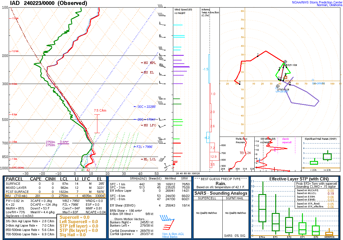
54 minutes ago, George BM said:
There some very skinny elevated CAPE depicted on the 0z IAD sounding w/ an EL all the way up around 33,000ft. A very small slither of CINH around 575mb.
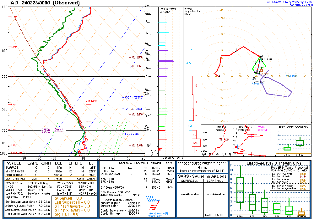
This is what I was saying, based on the forecasted soundings. If you start a parcel around 700 mb (710, to be precise, per the diagnostics), you do have some actual CAPE. It's just rare here to get convection based that high. The April 2011 comparison you made is likely a really good one.
-
3
-
2
-
-
1 hour ago, George BM said:
Another relatively strange (for this area anyway) elevated storm event was what occurred on the evening of April 3, 2011. Radar returns were not too impressive as activity moved through from NW to SE from mid evening into the first few hours of April 4th. But there was photogenic lightning for several hours, especially across northern MD from Frederick, MD and between Baltimore and DC.
I remember that event. The lightning was incredible.
-
1
-
-
9 minutes ago, Kmlwx said:
Is there ducting going on?
For sure. There is a stout low-level inversion which is perfect for getting those loud rolling rumbles.
-
5
-
-
Very bizarre. The model soundings certainly don't suggest thunder, unless you lift a parcel from up around 700 mb, and that's rarely a path to thunder here.
-
4
-
2
-
-
28 minutes ago, WxUSAF said:
Remember when @high risk, the guy who helps program them, told us that the hrrr and rap suck?
For snow. Jesus, I'm gonna get fired.
-
5
-
29
-
-
1 minute ago, paulythegun said:

There are many times when the accumulated snow depth product should be examined, but it hates events with marginal temps and big rates like this one.
-
3
-
1
-
1
-
-
The details weren't perfect, and it wasn't consistent run-to-run, but some of the NAM Nest runs yesterday did have some handle on the dry slot:
-
7
-
-
1 minute ago, MDScienceTeacher said:
But the GFS just showed more than the HRRR
I was mostly speaking in jest, but 1) 10:1 maps are not good for interpreting model snowfall in events like these 2) I'm still troubled by the NAM Nest not showing much here. Maybe it will cave at 00Z, but it has a good track record in events like these at shorter ranges.
-
5
-
-
Goddamnit, y'all. I have literally worked as a RAP/HRRR developer, and I would still use the JMA or NAVGEM before I used the RAP/HRRR system for snow amounts.
-
2
-
28
-
-
5 minutes ago, RickinBaltimore said:
From NOAA:
The Rapid Refresh Forecast System (RRFS) is the National Oceanic and Atmospheric Administration’s (NOAA) next generation convection-allowing, rapidly-updated ensemble prediction system, currently scheduled for operational implementation in 2024. The operational configuration will feature a 3 km grid covering North America and include deterministic forecasts every hour out to 18 hours, with deterministic and ensemble forecasts to 60 hours four times per day at 00, 06, 12, and 18 UTC.The RRFS will provide guidance to support forecast interests including, but not limited to, aviation, severe convective weather, renewable energy, heavy precipitation, and winter weather on timescales where rapidly-updated guidance is particularly useful.minor addendum: it's still very much experimental and is not scheduled for implementation now until 2025
-
2
-
2
-
-
It's not the kiss of death, but major red flags should always be raised with regards to accepting a 12 km NAM solution when its 3 km nest shows something different.
-
13
-
-
It always warms my heart to see the snow depth maps posted here, but this is not the type of event for which they do well. They limit accumulation when surface temps and soil are warm, and they'll never capture the ability of heavy rates to overcome marginal thermodynamics. I'd probably either average the 10:1 and snow depth products or mentally adjust the 10:1 maps downward. Kuchera maps might be good too - I hate how generous they are with colder temps, but they seem to properly limit accumulations when the temperature is marginal.
-
5
-
6
-
-
1 hour ago, WxUSAF said:
lol anyone look at radar lately??? Da fuq??
bright banding??
-
I'll take a few of those convective bursts of snow at the end of the event, please.
-
18
-

2024 Severe Weather General Discussion
in Mid Atlantic
Posted
No doubt, but the problem is that the CAMs seem in pretty good agreement that the timing is just really bad for us. Those storms won't approach the PA/MD border until just after dark at the earliest, and temps will be cooling fast. For the record, it's complete bullsh*t that central PA gets a legit early season threat before we do.