

osfan24
-
Posts
3,679 -
Joined
-
Last visited
Content Type
Profiles
Blogs
Forums
American Weather
Media Demo
Store
Gallery
Posts posted by osfan24
-
-
Just over an inch here. Definitely some winners and losers with this one. Think I landed pretty much in the middle.
-
I’ve had about an inch or so total out of this system.
-
 1
1
-
-
If this was 2 months ago, especially after nearly the past decade, I’d be looking for the nearest bridge to jump off of, lol.
-
 1
1
-
-
D+? One decent storm and not much else. I missed out on the epic squall day, which might have been the coolest part of winter for some. That said, there were a bunch of days with snow showers or flurries, and the decent storm timed up well with cold air behind it for almost the entire month of January, so there was snow over for almost an entire month. February was just such a disappointment, and our third snowiest month has been just really windy and now warm and there is nothing to track. The season basically ended in late February in terms of tracking anything. It was probably a B- considering expectations heading in and given recent years, but it seemed like we missed some opportunities once it actually got going.
-
Flurries. Must have come down harder for a few minutes because I have a light dusting on sidewalk and it stuck to the street in spots as well.
-
6 minutes ago, Bob Chill said:
No but only because guidance had the leaf of WAA further north at this time. Already sticking in RIC so better lift to my east but things look like they are breaking in my favor for a time
Sad to hear Richmond is getting anything.
-
 1
1
-
 1
1
-
-
Just now, midatlanticweather said:
Late 1990s there was a storm that the Nam showed 11 inches falling in the Reston area of Virginia. Snow. Was forecast by other models but nothing like that. And boom.. It happened. It was a fluke but maybe it found a nut this time.. Lol.. Weenieism philosophy
I thought the NAM wasn't even developed until after the January 2000 storm specifically because of that major model miss?
-
Saw there was a ton of posts in here and was wondering what in the world was going on. Can't say the number of posts matches the models lol.
-
1
-
-
Unless there is another -AO/-NAO upcoming, I don’t see much to get excited about. Either way, after this latest massive fail, the de amplification trend all winter plus the Route 50 South train tracks make it hard to get interested.
-
3 minutes ago, nj2va said:
I honestly find the regional hate around here, especially during snow events, to be so absurd. RIC vs M/D line…eastern shore vs metro areas. Some people here are straight up children and the worst comes out in forum divider events. It’s only snow, life will go on.
It’s naturally bound to happen in a forum that covers so much geographically, but where the large majority of those in the forum live in a relatively small area. Also, the region covers everything from the mountains to the coast, so it’s almost impossible that the entire region ever experiences the same results from a snowstorm.
-
1
-
-
1 minute ago, AlexD1990 said:
So very mature of you. Maybe this is why you're not getting any snow because like I've said for the past 3 days, karma is always watching.
The lack of self awareness is really something to behold.
-
2 minutes ago, AlexD1990 said:
I'm not sure what he's even talking about because I'm also in Southern Delaware and I'm certainly not expecting seven at this point.
Don't be an ass.
To be fair, we do have our own thread because let's be honest, everyone in this thread likes to pretend that civilization ends at the Bay bridge.
It does.
-
2 minutes ago, Rvarookie said:
For those in my DMs asking for place to stay in Richmond…the local news is reporting roads will be “treacherous” so please be safe on your drive down
I’m not even sure how much I want the snow now. I just hope you have to build an ark for your flood down there.
-
2
-
3
-
-
3 minutes ago, bncho said:
don't get me wrong... its a good run but its more south.

Euro still keeps the HECS scenario in play. Has there ever been a storm with this kind of result, though? A storm that destroyed that specific area? Not one that comes to mind. Usually it’s either a southern slider, a region-wide hit or it’s one of those coastal scrapers in Nina’s that hit the beaches, NYC and NE.
-
33 minutes ago, jayyy said:
Hahahaha he meh’d 12+ for the entire forum. Did you actually expect we’d get 18-24”? Come on now. Keep your expectations in check and you’ll stop always being disappointed. The euro is pretty much in line with the ukie and gfs. Even king euro comes back down to earth.My kids were born in 2015 and after. They’ve never seen a big storm. The ingredients are there. 12 is fine, but it’s not a big storm like 1996, 2000, 2003, 2009. 2010, 2016. I want to them to get to see a big one.
-
1 minute ago, Weather Will said:
Come on folks....look at the snow predictions at the beginning of this winter. We could be more than triple those predictions by the end of this week. Sustained cold and snow... great winter if the midweek storm verifies.
Snow predictions at the start of the season are irrelevant at this point. The ingredients are there for a rare HECS after 9 years of mostly trash winters. Gotta convert. It’s like getting to Super Bowl and getting blown out and being happy you made it there.
-
1 minute ago, winter_warlock said:
What the fuck do u want???? Lol
The good runs?
-
Meh. Not a great trend on the Euro the past two runs.
-
2
-
3
-
 2
2
-
7
-
 1
1
-
3
-
-
Just now, stormtracker said:
Noticing that the heights out front aren't quite as high as 6z...
Uh oh
-
The good news is in another run or two, we will no longer have to worry about extrapolating the Euro at 6z and 18z.
-
2
-
-
5 minutes ago, Ji said:
its not a good run--it was a bit east. I think we lost 7 inches

LOL that’s noise. There’s almost 30 inches just east of the metros.
-
1
-
-
3 minutes ago, bncho said:
FOLKS

LOCK IT UP! Why can't it be Wednesday already?
-
4
-
-
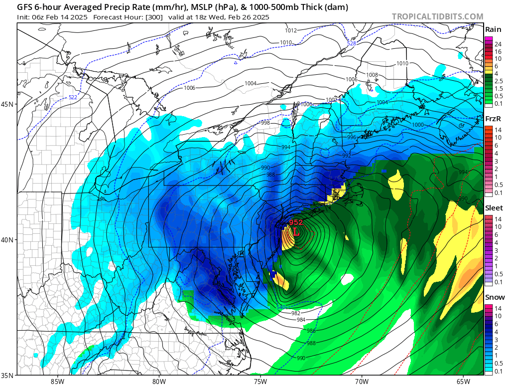
SECS=6-12
MECS=12-18
HECS=18-30
BECS=30+
-
3
-
-
47 minutes ago, Ralph Wiggum said:


2/26 btw
I think we should just do February 2010 over again.
-
1
-
2
-
2025 Severe Weather General Discussion
in Mid Atlantic
Posted
Same.