

osfan24
-
Posts
3,474 -
Joined
-
Last visited
Content Type
Profiles
Blogs
Forums
American Weather
Media Demo
Store
Gallery
Posts posted by osfan24
-
-
1 hour ago, WxUSAF said:
What happened to the forecast decaying MCS overnight? Looks like sprinkles in VA and clear skies here.
Feels like models in general have played up the rain this week that hasn't happened. I wasn't expecting periods of rain but I haven't seen a drop.
-
 1
1
-
-
17 hours ago, Eskimo Joe said:
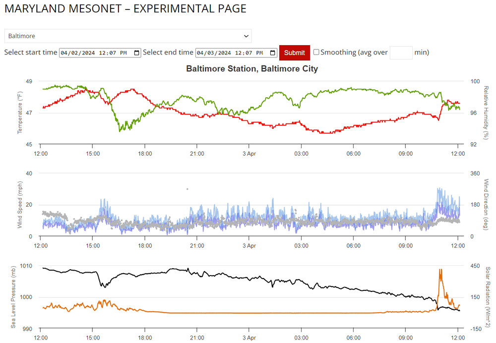
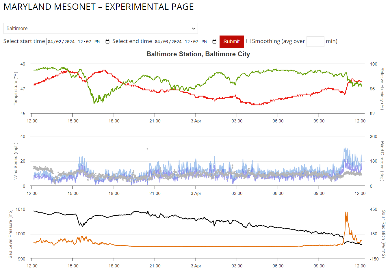
Looks like a wake low spun through Baltimore through NE MD:
Check out the temp spike (Red Line), Wind gusts (blue lines), and pressure drop (black line), along with a brief spike in solar radiation from the clearing behind the low...probably from some brief subsidence.
I was wondering what happened. The rain was just about to pull out and suddenly it got very windy here. Did not see any trees down, but tons of small and medium sized branches everywhere.
-
LOL. Now we are.......two weeks away! And out to March 26!! If we just keep going long enough, we can get back to December!
-
3
-
 9
9
-
-
2 hours ago, Ji said:
im only looking at the March 18-21 window....after that---the pattern change to cold looks-----no so cold anymore lol

Shocking development.
-
51 minutes ago, psuhoffman said:
FWIW guidance is still on pace for the longwave pattern to shift between March 10 to March 15. The problem is the whole continent is torched and so it would take another week after that before lower level thermals are even remotely cold enough in the east and by then were getting into the timeframe that boundary temps along 95 are really a problem. Places NW with elevation its still possible maybe March 20 on hey could sneak in something...I'm skeptical even there.
As opposed to our boundary temps in January and February?

-
1
-
-
3 minutes ago, psuhoffman said:
Another example.

yea look at that trough off the west coast extending up into NW Canada blasting pac puke into the conus. I get there is no way we could get snow because…oh wait sorry that’s March 58!The difference is the waters weren’t as warm so pax puke was less puky.
Kinda hard to deny what is happening when you see that.
-
I am actually surprised we haven't gotten more big March storms lately. It seems more just like really bad luck than anything else. Crazy stuff can happen in March.
-
When is the PDO going to flip positive? When was it last positive?
-
14 minutes ago, Weather Will said:
I think the issue is that people want this thread to stay focused on winter weather possibilities or other significant weather events expected through March. Having to go through pages of other dialogue to find posts that focus on the threads topic is tedious.
Like what? LOL.
-
The P25 Nina looking storm that hits the coast and misses the cities would be the perfect ending to this awful winter for the cities.
-
2
-
1
-
-
0z GFS looked like it spawned a hurricane lol.
-
1
-
-
7 hours ago, Ji said:
And here we go!
Sent from my SM-A515U using Tapatalk
And by players on the field, he means potential subscribers. There is absolutely nothing to get excited about or interested in right now. And given what happened last time we started warm and it took weeks to cool off enough to snow, good luck trying to run that back in March, if that's even the pattern that evolves, which it probably won't be.
-
1 hour ago, Blizzard of 93 said:
The latest Weeklies get the patten workable by the week of the 11th to the 18th.
The pattern on the Weeklies then continues to look workable through the end of March.


Problem is workable at that point isn’t going to cut it.
-
 1
1
-
-
Obviously very disappointing but the snow held fairly strong today with it being pretty cold and fairly cloudy with some flurries around. Very pretty sunset. So, some positives.
-
1
-
-
32 minutes ago, snowfan said:
All it takes is 1 storm. January 96 and January 00 were both in Nina’s. Outliers, yes, but it can happen.
I really don’t understand how 96 happened in a Nina.
-
11 minutes ago, Weather Will said:
WB 6Z CFS: if it is right the rest of February is too warm to snow. First week of March has a window of opportunity and the last 10 days of March look cold.


Oh good, cold just in time for it to be too warm to snow unless you live in PSU land.
Doesn’t really matter to me now anyway. This season has been a disaster and the only thing that can save it is a HECS, which isn’t even worth fretting over or paying any attention to models unless the NAO dips.
-
 1
1
-
-
Saw there were like 70 unread posts in here and thought maybe something exciting was going on with next weekend. Uhhhhh, no.
-
2
-
2
-
-
1 hour ago, psuhoffman said:
From 1964 to 2010 IAD recorded 21 days with 4”+ of snow and a high temperature below 28 degrees.
It hasn’t happened in 14 years since 2010.
That shocks me that there weren’t a bunch of days like that in 2014 and 2015. Also feel like there have been a few storms since maybe 2018 where I thought that may have happened.
-
30 minutes ago, rjvanals said:
From 1-2AM last night it was pretty sweet w legit heavy snow here so despite the disappointment in overall totals it wasn't a total bust imby.
Same. I got good snow for about 45 minutes to an hour, and then another 30-45 of steady snow. If I hadn’t, it would have been a dusting on the grass. Instead, I ended up around 3 inches and all surfaces covered, at least for a time, before the pavement melt began.
-
2 hours ago, psuhoffman said:
Like 3 days ago I said “we should ignore the south band and focus on the north, history says that’s where the goods will be and the south max will be disappointing” I let my desire for us not to be shafted influence me too much yesterday. For a time the guidance kept the fgen displaced south of the arctic boundary and indicated two separate legit heavy snow bands. But things converged on a more historically typical outcome with the fgen shifting north with the better thermal gradient along the arctic boundary. I should have seen that coming. I did from 3 days then kidded myself when crunch time came.
Was coming here to post that you really nailed that. Wild to see that band sit and just absolutely dump. Could have been in the 10-14 inches band, but then again, had that band parked somewhere over us, it was so thin that there would have been a lot of devastated fellow forumers.
I guess we all learned something from that setup for the future, however.
Ended up with about 3 inches here just eyeballing. Perhaps some compaction but not enough snow for it to matter. I, like you, woke up to a melted driveway lol. WTF. I am so depressed with what’s going on with our climo for snow.
-
Street caved. Dumping good here. Just need three more hours of this lol.
-
Down to 33 and snow picking back up. Sidewalks and driveway caving. Street trying to cave in spots.
-
Please tell me something good lol.
-
1
-
-
Even that great band up by Harrisburg has dissipated and it looks like they are basically done.
I think I’m out in the future on these real short duration events. Just expect a couple inches and be surprised if you get more. Just too dependent on really heavy rates to do any better.


May Discobs 2024
in Mid Atlantic
Posted
More rain today than the entire week so far. A mist transitioned into a light, steady rain.