

jbenedet
-
Posts
7,838 -
Joined
-
Last visited
Content Type
Profiles
Blogs
Forums
American Weather
Media Demo
Store
Gallery
Everything posted by jbenedet
-
The upside potential remains very high.

-
And that’s with very limited northern stream involvement.
-
I mean it’s both. No? Instead of the track ENE/NE trajectory more like an open wave we see it bend/tug back a bit, more akin to a maturing system. That’s my thought process.
-
Increased phasing, and more rapid synoptic wave development... that’s my guess anyway.
-
The northern stream is trending towards increased phasing... What happens if 6z GFS hr 42 looks more like this?

-
All op guidance is on the progressive/fast side of the envelope. The teleconnections and a short wave traversing the Northern GOM argues for the amped/slow side .... Risk remains strongly in favor of major guidance trending further in this direction...
-
Wrong. Sir. She gon slowwwww down.
-
The big one on Sunday/Monday cheers
-
Active mid December with multiple event potential
jbenedet replied to Typhoon Tip's topic in New England
This analog was circulating yesterday. Reality will look something much more like this. Where the gradient really sets up is difficult to know, but my best guess is right around I-90. Shift this roughly 50 miles north... Harvey has me in 2-6”. I’ll take pics of my overcast.
-
Active mid December with multiple event potential
jbenedet replied to Typhoon Tip's topic in New England
I called the forecast north of I-90 trash not him -
Active mid December with multiple event potential
jbenedet replied to Typhoon Tip's topic in New England
Wishcast away my friend. -
Active mid December with multiple event potential
jbenedet replied to Typhoon Tip's topic in New England
I’m sorry this is worthy of the trash. There’s going to be a really sharp gradient along I90 ish. It’s going to be a great storm south of there. More of a “feast or famine...” The global guidance continues to flag significant dry air/subsidence, to the north of I90. That’s why snowfall total maps are not jiving well with the apparent precip shield to the north. To me, that’s a giant red flag that what will we be seeing is a lot of radar echoes with little/nothing reaching the ground. That 4-8, 2-6 area is going to bust very high, unless there are big changes between now and go time. -
Active mid December with multiple event potential
jbenedet replied to Typhoon Tip's topic in New England
Good analog -
Active mid December with multiple event potential
jbenedet replied to Typhoon Tip's topic in New England
Yea no kidding. This is pretty much exactly what he should want at this stage for being on the Cape in mid December. One, rare time I wouldn’t be worrying about p type issues either. -
Active mid December with multiple event potential
jbenedet replied to Typhoon Tip's topic in New England
If the cold was advecting from the north west, we could get this to bend back north through traditional yntopic wave development...All of the cold is over our NNE heads and due north... it’s an East trajectory...sharp cutoff to the north... -
Active mid December with multiple event potential
jbenedet replied to Typhoon Tip's topic in New England
Hope springs eternal. -
Active mid December with multiple event potential
jbenedet replied to Typhoon Tip's topic in New England
It doesn’t. Was talking about ICON. -
Active mid December with multiple event potential
jbenedet replied to Typhoon Tip's topic in New England
Support from models with poor verification scores isn’t forecast support. It’s just giving false sense of confidence. -
Active mid December with multiple event potential
jbenedet replied to Typhoon Tip's topic in New England
The ukie looks like GFS through 72hr. I don’t buy that 1003 SLP at 96. It should be a stronger system further south... -
Active mid December with multiple event potential
jbenedet replied to Typhoon Tip's topic in New England
Wagons south -
Active mid December with multiple event potential
jbenedet replied to Typhoon Tip's topic in New England
Are we really resorting to the ICON? How have we reached this level of denial already.... -
Active mid December with multiple event potential
jbenedet replied to Typhoon Tip's topic in New England
947 mb low North of NL at hr 72 on the ukie. Weenie crusher.... -
Active mid December with multiple event potential
jbenedet replied to Typhoon Tip's topic in New England
That’s a red flag that the SLP is too far north imo. Disturbance can’t pump downstream heights into a 1038 mb Arctic high anchored over southern QC/NNE. The previous panel looks very similar to 12z GFS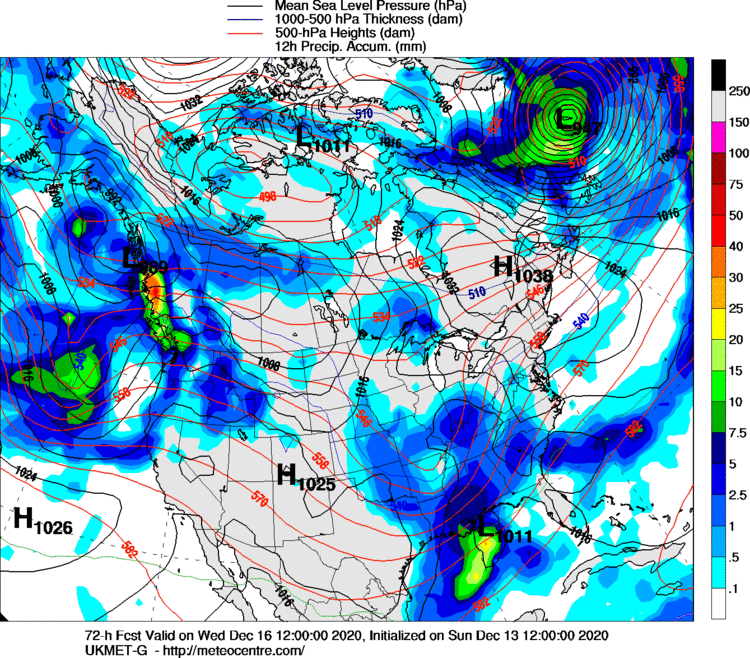
-
Active mid December with multiple event potential
jbenedet replied to Typhoon Tip's topic in New England
The airmass and associated surface HP over NNE is a rock. That’s why the SLP gets shunted East despite sharper UL trough... -
Active mid December with multiple event potential
jbenedet replied to Typhoon Tip's topic in New England
Right now NYC/LI is my “highest confidence area for a significant snowfall”. Right now looks like an all snow event down there to me. Very cold dews should make that attainable... and the mid levels are never an issue with this given the synoptic development.......





