

Fozz
-
Posts
37,601 -
Joined
-
Last visited
Content Type
Profiles
Blogs
Forums
American Weather
Media Demo
Store
Gallery
Posts posted by Fozz
-
-
The sun is peeking out, very picturesque late afternoon view but it's basically snow TV.
4" on the dot.
-
4 minutes ago, psuhoffman said:
The pattern should get good again, just in time for me to return from Seattle on the 10th.
I was thinking of a Whistler trip in early Feb.
-
Down to pixie flakes. 3.8” with 7.3” depth
-
 1
1
-
-
Just now, nw baltimore wx said:
I'm feeling like I'm in a good spot for the remainder of the storm. I'm going to weenie my way to over 6" when that band sets up over me.


Fingers crossed! Radar is looking slightly better and I'm about to do another measurement.
-
1
-
-
3 minutes ago, Ji said:
Haven’t even seen moderate snow since I woke up. DisappointingAren't you in Leesburg? I thought you're up to 6" now
-
7 minutes ago, DDweatherman said:
Nj2 and I were in the mountains for the MLK storm + upslode event 2 years ago, couldn't link up that trip but want to get back out there for another doozie. That one was sick, a 20" event and whiteouts in the upslope bands + the winds behind the low.
I was there as well. Tried to meet up with nj2va but it didn’t end up happening. That one was incredible.
-
36 minutes ago, katabatic said:
So the forecast for Garrett County is just epic. Not surprisingly, I cannot get anyone to go tubing with me at Canaan tomorrow (but had to buy tickets not only for tomorrow but Sunday as well...the only way to experience this is to be out in it!!) but @nj2va is in town and he and I are meeting at Mountain State Brewing Co (6690 Sang Run Rd. McHenry) tomorrow at 7 PM if any other like minded weenies are in the area. First round and pizza is on me. This is a time for celebration.
I thought about heading to the mountains this weekend, but the storm will mostly be over after tonight and the temps will be absurdly frigid with double digit negative windchills, so I chickened out

-
3.5” and still coming down
-
2
-
-
2 minutes ago, Maestrobjwa said:
Wait...seriously???
I think we’ll end up on the lower end of that range.
-
1
-
-
It really is a snow globe outside.
For those of us near Baltimore and especially north, this past week might be our best stretch of winter since 2016.
-
3
-
-
Just now, ravensrule said:
It is snowing really nicely. Over 3”.
Seems like the good stuff will be sitting in our area for a while. Radar looks excellent.
-
3
-
-
Sitting in a sweet band now.
Just over 2” new
-
1
-
-
2 minutes ago, Terpeast said:
Lol i’m commenting on the aesthetics of it.
Technically, yes that’s my total for this week. 4.8” + 3.3” is over 8” but more like 6” with compaction
Oh ok it was one of the first posts I saw when I opened the thread and I was a bit shocked for a second.
But glad to hear it’s a great event!
-
1
-
-
4 minutes ago, Terpeast said:
Beautiful out there. Looks like it just snowed 8 inches
Are you serious??
Or is that your total snowpack?
-
 3
3
-
 1
1
-
-
4 minutes ago, nj2va said:
I don’t remember two events in a single week trending better within 24 hours of start time. This mojo will continue in February for our HECS.
I do.
In 2010
-
2
-
-
29/17
Really looking forward to this. We haven't had a good run of deep winter in years.
-
2
-
-
5 minutes ago, SomeguyfromTakomaPark said:
6z ICON looks decently moist. Would be nice to get this precip in closer to 4-5 am to maximize the accumulations. If it comes in closer to 7-9 am it’ll be lower impact.
Does the timing with daylight really matter in mid-January?
I always thought it’s much more of a factor in late February and March.
-
2
-
-
14 minutes ago, jayyy said:
Clearly not that obvious since numerous people in this subforum obsess over HECS like they are supposed to hit us seasonally
We've been spoiled with the big ones for a long time, especially from 1996 to 2016. When half of DC and Baltimore's top 10 snowstorms in the last 130 years were in that 20 year period, then you know it's been a golden age for the mid-Atlantic HECS.
-
3
-
-
6 minutes ago, WxUSAF said:
93 was obviously a HECS, but not based on snow totals along I95
5 minutes ago, Fozz said:It was historic for the N/W areas and interior. Naso much for the coastal plain.
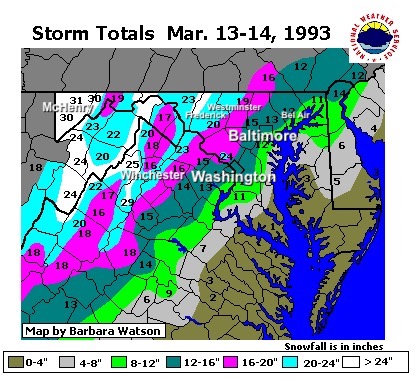
Easily MECS level in the cities, and definitely historic and possibly an all timer in the interior. I can’t speak for it but those in the blue and white areas who are old enough to remember truly witnessed something exceptional.
-
1
-
-
Just now, WxUSAF said:
93 was obviously a HECS, but not based on snow totals along I95
It was historic for the N/W areas and interior. Naso much for the coastal plain.
-
2 minutes ago, osfan24 said:
I am not worried about a week or so relax. I am worried about the NAO.
When there’s a strong -NAO in the first half of a season (esp El Niño), it tends to return later. Happened in 2009-10 and many other such winters.
I think a big storm is fair game for later this season. This isn’t 2010 or 1996, but it sure isn’t last year either.
-
1
-
-
I’ll be so happy with 2”
Anything more is a bonus
-
3
-
-
Ended up with 4.4” IMBY.
It was a fun storm and very much needed. Hope to see much more on the way.
-
2
-
-
Just got back from a long drive from WV.
2.9”
And now we’re in a warning? Let’s gooooo!

-
3
-
Jan 19th Storm OBS Thread
in Mid Atlantic
Posted
I've been trying to find the Manchester camera on MD traffic cams, but I can't find it there.
Link?