

ILSNOW
-
Posts
1,644 -
Joined
-
Last visited
Content Type
Profiles
Blogs
Forums
American Weather
Media Demo
Store
Gallery
Everything posted by ILSNOW
-
-
UKMET with a nice spread the wealth system
-
while the GEM favors our southern friends
-
V16
-
7 here and currently under a nice band
-
Just measured 6 and still snowing lightly
-
would guess 3-4 inches out here
-
and KLOT nice update from Ricky UPDATE... 1015 PM CST There have been no changes made to the going Winter Storm Warnings and Winter Weather Advisories. However, based off conditions in the pre-dawn hours, the midnight shift may give consideration to converting some of the warnings over to a Winter Weather Advisory. This is because snowfall rates aside from lake enhancement near Lake Michigan are expected to be mainly light and occasionally moderate on Tuesday. The main message tonight remains hazardous travel due to a variety of winter hazards, snow covered roads, reduced visibility and at least patchy blowing snow in the north due to 30-40 mph northeast wind gusts, and freezing rain and drizzle south. Have overall lowered storm total snowfall a bit to only locally to 6+" inland and highest amounts near Lake Michigan in Illinois at 6-8", maybe a few spots coming in just above 8"+. These changes were reflected in the updated WSW text product. The evolution of our winter system is quite different from just a few days ago, as double or triple barreled weaker low pressure is analyzed from southwest MO to western KY, instead of a stronger low lifting northeast of the Ohio River. Forcing is being driven by weakening, but still certainly sufficient large scale forcing from 500 mb short-wave, along with mesoscale f-gen (thermal gradient) driven forcing at the lower and mid-levels, plus also augmented by convective processes by very steep lapse rates aloft. Trends have been a challenge this evening, as we`ve been fighting pockets of dry air aloft. Most notably, dry air centered around 850 mb was driven into far northern Illinois and southern Wisconsin earlier, which guidance did a fairly poor job of capturing. That dry air finally lost out as snow banding finally pushed north. There`s been some good f-gen driven banding amidst the dry air issues, so reports of nearing 2" have trickled in centered near I-88 and just south. More convective elements have been streaming northward out of central Illinois thanks to aforementioned very steep mid and upper lapse rates sampled by DVN RAOB. The dry air at 500 mb and above is allowing for convection to help fill in some of the dry pockets where snow has been more prevalent and this should be the case north of I-80 for a decent chunk of the overnight. 850 mb warm nose appears it made inroads into our far southern CWA near and south of US-24, while to the north of that varied precip types have been from pockets of saturation amidst some 700 mb drying and above described convection that has brought reports of snow and sleet. This dry layer at 700 mb will shift northward overnight, causing a loss of cloud ice in the DGZ and introducing a concern for some freezing drizzle from I-80 and south into Tuesday morning. It appears that for areas to the north of that up to around I-88 corridor, saturation depth will be to just cold enough at -9 to -11C to keep snow as primary p-type. Steady generally light to moderate snow rates with briefly heavier snow will occur until about 3 or 4 AM, and then expecting the lake enhancement to take hold along the Illinois shore. On Tuesday, the 500 mb and 700 mb circulations will slowly translate across the area, keeping lighter snow going and resulting in light additional accumulations of 1-2/1-3", but higher near lake in IL at up to 2-5". The midnight shift will assess transition to lake effect snow Tuesday night, which should last into Wednesday and add additional accumulations for affected areas. Castro
-
Milwaukee update UPDATE... (Issued 1002 PM CST Mon Jan 25 2021) Based on water vapor imagery, it looks like models are really struggling with the placement of the mid-level wave as it slowly rotates and weakens across eastern Nebraska and Iowa. Radar trends are misleading this evening, as dry air has won out thus far. However, we are finally starting to seeing ceilings lower across far southwest Wisconsin and have reports that snow is beginning to fall across southeast portions of Wisconsin. So, we do still expect widespread snow to lift across southern Wisconsin late tonight, bringing impacts to the Tuesday morning commute.
-
Literally not a flake since the late afternoon flurries
-
there is an 18.3 in there for u
-
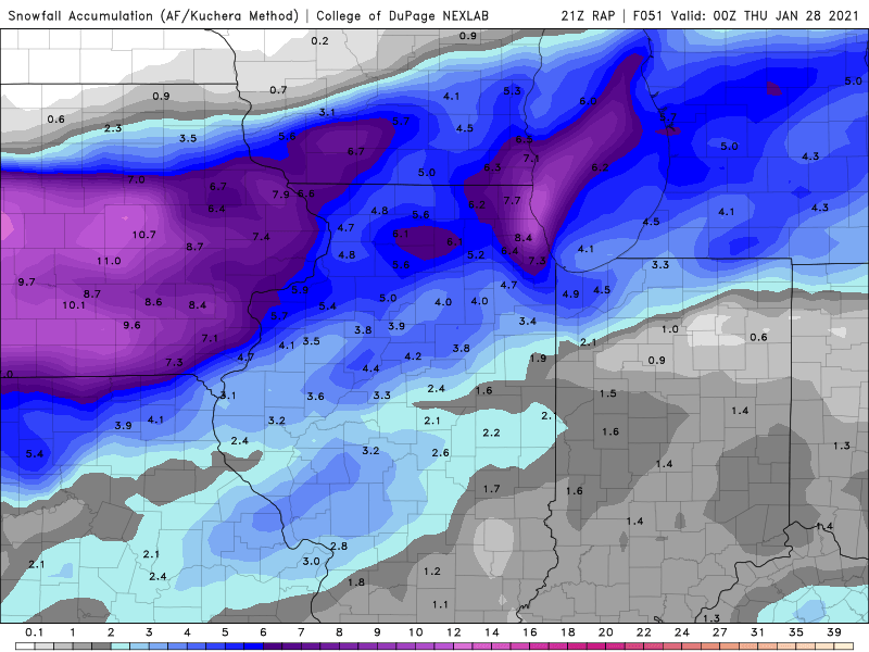
21z RAP
-
first flakes here
-
-
-
12z GFS looks like it keeps the lake effect going thru Wednesday.
-
another one for u
-
pivotal look locally and regionally
-
-
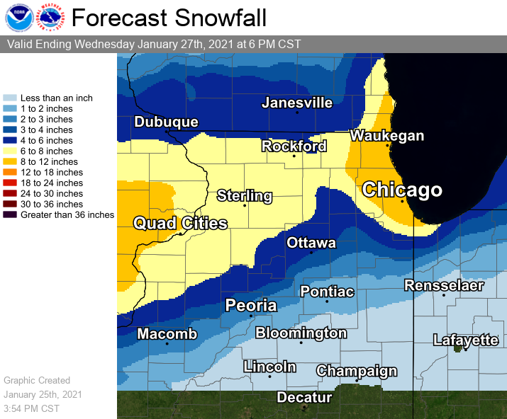
Quad Cities does not listen to the American Weather Board URGENT - WINTER WEATHER MESSAGE National Weather Service Quad Cities IA IL 243 PM CST Sun Jan 24 2021 ...Winter Storm Developing Monday through Tuesday Morning... .A powerful storm system will bring heavy snow, strong and gusty winds, mixed freezing rain and snow, and considerable blowing and drifting snow to the region through Tuesday morning. Snow and freezing rain will develop toward daybreak in far southeast Iowa and west central Illinois. Snow will slowly spread north through the day, reaching Interstate 80 and the Cedar Rapids to Quad Cities metro areas between 2 and 4 PM Monday afternoon. Farther north, after a mainly dry afternoon, snow will arrive towards the evening commute along Highway 20 in Iowa and Illinois. At this time, much of southeast Iowa and east central Iowa into northwest Illinois is at risk for seeing 6 to 12 inches of heavy wet snow, with considerable blowing and drifting snow Tuesday night. Locations in the far north will see less snow, in the 3 to 6 inch range, and in the far south, a mix of snow, freezing rain and rain will limit snow amounts to the 2 to 5 inch rang .WINTER STORM WARNING IN EFFECT FROM NOON MONDAY TO NOON CST TUESDAY... Dubuque-Benton-Linn-Jones-Jackson-Cedar-Clinton-Muscatine-Scott- Jo Daviess-Stephenson-Carroll-Whiteside-Rock Island-Henry IL- Bureau-Putnam-Mercer-Henderson-Warren- Including the cities of Dubuque, Vinton, Cedar Rapids, Anamosa, Maquoketa, Tipton, Clinton, Muscatine, Davenport, Bettendorf, Galena, Freeport, Mount Carroll, Sterling, Moline, Rock Island, Geneseo, Princeton, Hennepin, Aledo, Oquawka, and Monmouth 243 PM CST Sun Jan 24 2021 * WHAT...Heavy snow expected. Total snow accumulations of 6 to 10 inches. * WHERE...Portions of east central and northeast Iowa and north central, northwest and west central Illinois. * WHEN...From noon Monday to noon CST Tuesday.
-
Somebody reach out to Ricky and tell him the American Weather board thinks that he should cxl the WSW. The KLOT area will prolly get 4-8 inches which we havent had in a long time and some are ready to cxl the storm. Folks we all want the snow and no its not going to be the big one advertised a few days ago, but maybe the drying on the models stops , maybe they get wetter again who knows lets see how it plays out.
-
-
lastest SREF Plume for ORD is down to 6.80 with only 1 member now below 5 with approx 9 members between 6 and 10.
-
Chicago Storm can you please post the 12z Euro Kuchera run if you have it? thanks
-
thanks i missed it


