

ILSNOW
-
Posts
1,433 -
Joined
-
Last visited
Content Type
Profiles
Blogs
Forums
American Weather
Media Demo
Store
Gallery
Posts posted by ILSNOW
-
-
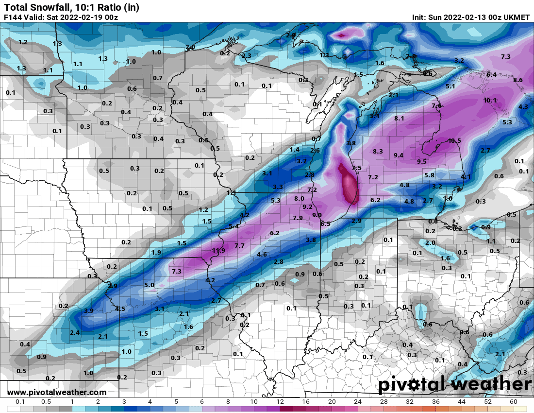
18z Euro

-
3 minutes ago, Hoosier said:
The verbatim snow/ice numbers and wind would be an extremely impressive storm in some areas. Still a ways to go though.

-
and total precip

-
-
Just now, cyclone77 said:
I'd sell off a section of my retirement for the 18z GFS to verify lol. On that note, time to go watch the super bowl.

yes that is impressive
-
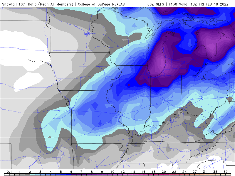
12Z Euro is not playing the GFS is on its own with the 2nd wave getting this far north. Nice 6+ from St Louis to Champaign thru Lafayette , Ft Wayne into Mich.
-
 1
1
-
-
to this amateur it appears the the 12z GFS is similar to 6z but has moved its heaviest snow band back south but we have a few days to figure that out. Happy to see back to back runs like this.
-
Ride the UKMET

-
 1
1
-
-
Question for the pro’s why does the GEFS look so different then the op run
-
Just now, sbnwx85 said:
For those keeping score at home, my first and final call of rain was for Wednesday. I haven’t made a decision for Thursday.
Partly cloudy
-
2
-
 1
1
-
-
lotta rain on 18z GFS with a few inches on the backside
-
1 minute ago, Baum said:
I'd argue this is only the second SW Low event(provided that happens) or moisture laden over running event of the season. Still, a more strung out solution seems like it has been the way to go for quite sometime. However, that does not preclude a 4"-8" event as we just saw. Or a heavy rain to freezing rain to back end 3" thump. Tis the season. No meteorology here just a amateur take.
Last nights 0z GFS had it coming out in piece the 6z and 12z now show a break in between. I really dont recall a heavy rain event going over to warning level snow. I also think that there is going to be a significant area of freezing rain some where in the Chicago metro area. Long way to go !!! An amateur snowlover take here.
-
Just now, Chicago Storm said:
there really has been not be any trend per say. other than it being a winter that has overall favored portions of MN/WI/MI in our sub-forum.
Care to share your early thoughts on this potential storm?
. -
2 minutes ago, Chicago Storm said:
definitely not the winter trend.
so what has been the trend this winter?
. -
GFS trends for Chicago
0z Total precip 2.60
6z Total precip 1.90
12z Total precip 1.30
following winter trend of south and drier for Chicago
-
was a typo he meant
10 final call
-
1
-
1
-
-
Oz GFS is snow porn for Chicago area
-
and then
"the over running alignment is different and the storm is south and weaker"
-
1
-
8
-
-
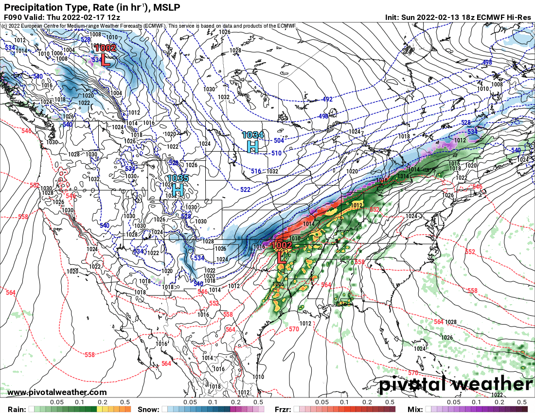
12z GFS still amped still wet and incredibly icy for portions of NE IL (still a week out and as others above have said we havent seen a wrapped up bomb in a long time)

-
12z Euro loving ALEK next week
-
1
-
-
7 minutes ago, Chicago Storm said:
Parameters do look a but better than they once did, but not that good.
I would have close to a foot today based off RAP and HRRR from yesterday. Which hi res model should do the best with lake effect?
-
4 minutes ago, RCNYILWX said:
If anyone from LOT CWA has reports from their area that you'd like to go out as LSRs, reply to my post here. Include estimated time you measured. Thanks.
3 inches here in Buffalo Grove 11am
are these amounts possible or as i believe way over done? close to 16 in the middle of that band

-
1
-
-
1 minute ago, A-L-E-K said:
18z hrrr gonna push 20" over n cook for a real
 run
run
-
Chicago NWS for lake effect possibility
Lake effect snow showers are expected to develop late this
evening, possibly across far northwest IN and then spreading west
into northeast IL. Confidence for lake effect snow showers is
medium to high, but confidence is low for timing/location. Trends
seem to focus a band near ord/mdw from the predawn hours through
mid/late Thursday morning. Opted to carry tempo mention for lower
conditions, but these could become prevailing depending on where
the lake effect sets up. And there is some potential for it to
continue into Thursday afternoon, especially near ORD and across
far northeast IL. Large changes are possible with the lake effect
as trends emerge tonight into Thursday morning.


Feb 16-17th Winter Storm
in Lakes/Ohio Valley
Posted