

BIG FROSTY
-
Posts
4,645 -
Joined
-
Last visited
Content Type
Profiles
Blogs
Forums
American Weather
Media Demo
Store
Gallery
Everything posted by BIG FROSTY
-
Ryan Maue | weathermodels.comVerified account @RyanMaue 4m4 minutes ago More Model guidance locked on SE North Carolina as a landfall location for Hurricane #Florence ... b/c of storm's size including a 200-mile margin puts a lot of coastline under threat of major hurricane conditions mainly on Thursday. ECMWF 12z update: (https://weathermodels.com )
-
Allan Huffman @RaleighWx 24s24 seconds ago More Overall the track once inland is a little west of the 00z track with the center moving into west-central NC. #Florence
-
Joe BastardiVerified account @BigJoeBastardi 7h7 hours ago More Since Wednesday we have had this going inland over NC and then crawling into VA. Should this turn out correct, this is likely to be the worst natural disaster on record for Carolinas into VA Major hit combined with 3-4 feet of rain in some places over 3-4 day period.
-
Ryan Maue | weathermodels.comVerified account @RyanMaue FollowingFollowing @RyanMaue More The most recent HWRF hurricane model suggests #Florence rapidly intensifies to a major hurricane -- and continues to Category 5 on Tuesday. The track in this model closely matches the official NHC forecast. The maximum intensity could be between Category 3 and 5 along the track 8:25 PM - 8 Sep 2018
-
Joe BastardiVerified account @BigJoeBastardi 7h7 hours ago More Models change, our forecast does not. If I am going to change ideas, will likely be next Wednesday. Same biases remain in models, same physical conditions, They dont change every 6 hours enough for one run to mean more than another
-
Allan Huffman @RaleighWx 42s42 seconds ago More So here are the 12z EPS (ECMWF Ensemble) tracks. Concerning to say the least. #Florence
-
You're right! A lot on the table here!!
-
I agree, could/would be devastating with this scenario!
-
[ Maybe a good soaker too! Wow!!! IMG]https://uploads.tapatalk-cdn.com/20180907/74b95859cd85a4badc1ffa9e610d569d.jpg[/img] .
-
Lots and lots of rain and wind inland!! Allan Huffman @RaleighWx 2m2 minutes ago More The 12z ECMWF track for #Florence
-
Looks a bit active!! Ryan Maue | weathermodels.comVerified account @RyanMaue 5m5 minutes ago More I'd expect all 3 to be hurricanes by next week ... Florence, Helene and Isaac. Something in the Gulf may be brewing as well -- and even if it is not named -- could be a heavy, tropical rain event for Texas. (ECMWF simulated water vapor satellite (https://weathermodels.com )
-
Allan Huffman @RaleighWx 2m2 minutes ago More One major concern I have with #Florence is that where ever it ends up making landfall there is potential for the storm to slow down significantly. Steering currents will be weak. Heavy rain may be a big concern where it makes landfall, assuming it does. Just one aspect to watch
-
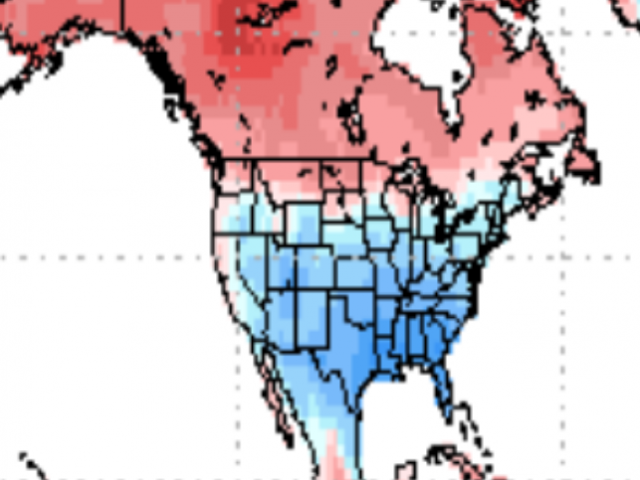
We have a model flip! I mean a night and day flip!! JAMSTEC August run for Winter... FROM to
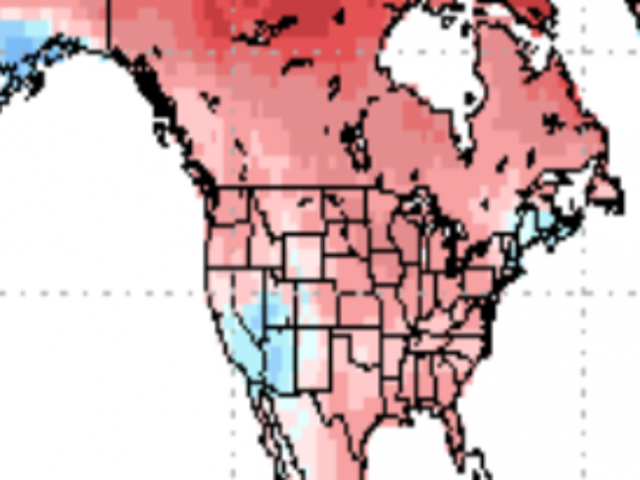
-
From: JB JAMSTEC: SINTEX-F predicts that a moderate-to-strong El Niño event may start in summer and reach its peak in winter.This El Niño is more or less of Modoki-type and we need to be careful of its impact that may be different from that of the canonical El Niño I am of the belief its a weak to at most moderate event. Point is they see the Modoki type, and their forecast is much like our analogs
-
You're right on as usual! lol
-
Looks like it may rain!! [emoji4] Per- Alan Huffman .
-
Awesome man, Great singing & playing !!
-
Cool dude, I love fishing at the OBX !!
-
Wow, Still looks to be chilly!!! Snow in the High Country?
-
-
Yep Va. Special, BUT Brad P. just posted this!! 1 min · Twitter · Retweeted Brad Panovich (@wxbrad): #NASCAR should be fun this weekend in @MartinsvilleSwy #snOMGhttps://t.co/PYJvXFNnRi
-
Light RN/IP mix 34.8
-
Heavy Sleet 37.2
-
Got a Thunderstorm and 38 degrees!!
-
Come on up Mack, We'll go carp fishing in the snow!!!


