
bwt3650
-
Posts
1,570 -
Joined
-
Last visited
Content Type
Profiles
Blogs
Forums
American Weather
Media Demo
Store
Gallery
Posts posted by bwt3650
-
-
Let’s do it. Jay took a bit of a hit today on the webs for that snow report.
Multiple reports of about 5” from people. I mean 10-14” overnight is like 35dbz snow ripping for 10 hours.
Snowing hard in town in Stowe now. Lookout Cam averaging 1”/hr past 3 hours.
A lot of convective graupel in this too.
It’s ripping and models have the look of a northern greens upslope special tonight…Jay should clean up…would be ironic if tonight they actually do pull off a foot.
.-
 1
1
-
-
Thanks for being our boots on the ground. No doubt it's a nice start to the season up there but really wish we could rely on their numbers. I feel like we should crowdfund you to run a covert high road plot in some hidden thicket at 3000'.
Ha..I would do it in a minute; I’m just not up there full time yet. In a few years, I’ll at least try to do something at 1900’ where my spot is. I think it’s important for what is the snowiest spot in the East.
Yeah, I’m not sure why they went 10-14. They catch a lot of crap for their totals and honesty, it’s pretty close most of the time, but this is a bit of a head scratcher. People that don’t spend a lot of time there can’t comprehend the amount of snow they get and the fact that the angle of that mountain and lack of anything blocking the moisture feed makes it so much better for upslope. Probably only Stowe in the same league in that area and jay def gets more…how much more is debatable, but it’s more.
The skiing is really incredible right now. They don’t need 10-14 to convince anyone.
. -
How the hell did Jay pull 10-14" from this last night? Not exactly their classic setup.[mention=10397]bwt3650[/mention] you up there?
It wasn’t 10-14 last night…I don’t know where they are getting that.
. -
Beginning of thread:
”bring the cold first, the snow will follow”
Current:
”we have precip, now we just need the cold”
Can’t make this stuff up lol.
Perspective…it’s 4 days into meteorological winter…the first 10 or so of Dec are BN..clipper might get some 2-4…mountains are cleaning up…everyone said mid month would warm..last 10 are unknown to everyone…
Let’s move on from the passive aggressive shit.
.-
 4
4
-
 2
2
-
 1
1
-
-
I saw 30” in 72 hours?! Holy shit gotta be thigh deep?
It’s probably pretty close, even for jay slant sticking. Taking into account fallen vs on the ground depth a few days later…Really impressive cycle since thanksgiving, but more importantly, a week straight of solid snowmaking
this is at 1900’….
.-
4
-
-

Meanwhile…
.-
2
-
1
-
-
If anyone has the means to get there, can’t stress enough how good the skiing is at Jay right now…ski right on to the lift, all of stateside off the jet and there are some woods in play, maybe more today with it still snowing. It’s mid winter powder and packed powder. If they get the Bonnie running by the weekend once they wrap up snowmaking at the base and unload, almost the whole mountain will be accessible with a little hiking. Wouldn’t be shocked to see the tram either. It’s really good.
. -
Is that persistent band near Franklin County Airport in Vermont typical with these setups? It looks like some Lake Champlain enhancement from the Ontario LES band. The low elevation also probably enhances the reflectivity relative to the terrain due to better line-of-sight. I feel like I've seen that feature before, but I don't usually look carefully for it. There doesn't seem to be any mention in the NWS BTV forecast.
Kinda cool.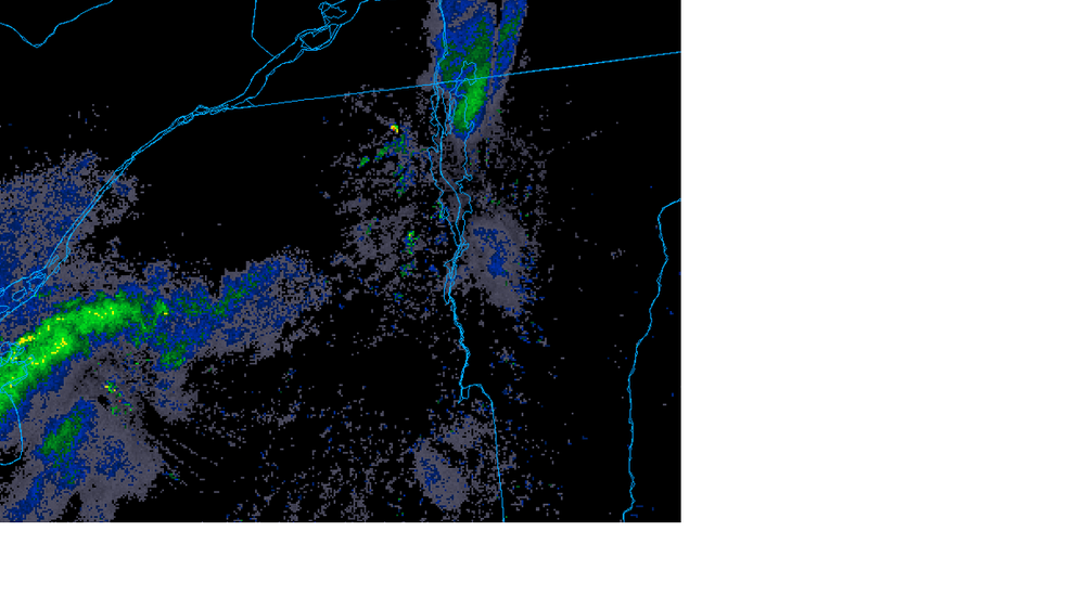

I’m far from an expert, but my experience is radar will never show what’s going on in this area well. It’s all about the flow…it’s been snowing almost non stop for 3 days here and very little shows up. If bands are approaching the orleans county border, we’re usually snowing well.
. -
Storm cycle total..should fire up again tnrw, but I figured I’d call this for thanksgiving through last night, since today is mostly just occasional flurries. The upslope far outperformed the storm system itself…

.-
7
-
1
-
-
It was absolutely incredible today. Hard to believe it was November. Snowed all day, almost every rope dropped on stateside off the jet, and was even able to dip in some woods…really good skiing. Can’t remember the last time I stayed out til last chair this early…


.
-
2
-
-
Looks great but “nuking snow” with visibility shown doesn’t pass the “I’m not a weenie” test.
1. I am a snow weenie.
2. Pic is about an hour ago..It’s nuking in my opinion, but I get it..currently
.-
1
-
-
Nuking snow again…4-6 so far and natural ropes dropping..


.-
6
-
-
Just let up, but was dumping snow the last two hours..cold, winter vibe here.

.-
12
-
-
Nice opening day..not too often it’s only jay and killington. Snow was very good above 2500’, more typical machine groomed stuff below. Opened a few natural trails with some great snow too…


.-
6
-
-
Gfs has been consistent with this band hitting the northern greens tnrw night for several runs now..

. -
This is probably the only thread that gets much discussion about the weather nuances in the Northern Greens, so I hadn’t even heard mention of much in terms of a bread and butter pattern, but I scrolled through the past couple of runs of the GFS, and it does have that look. The past couple of runs show the following parade of systems:
1) Nov 28-29: System passing through SNE
2) Nov 29-Dec 4: LES
3) Dec 5-6: Clipper
4) Dec 6-7: Clipper
5) Dec 9: Clipper/Coastal System
6) Dec 11-12: Coastal System
7) Dec 13-14: LES
There aren’t too many days in there without snow. Of course, those later events from a deterministic model are subject to plenty of change, but the general idea is there. A vertically-stacked low pressure system sitting over Northern Maine or the Canadian Maritimes is certainly a favorite setup around here, but those don’t happen every day, and they don’t often sit for too long. Having that closed upper low over Hudson Bay with broad upper level troughing is also a great setup when you have a 4,000’ wall of mountains sitting downwind of a moisture source like the Great Lakes. The BTV NWS is talking about it in their short-term discussion:
Area Forecast Discussion
National Weather Service Burlington VT
852 AM EST Thu Nov 28, 2024
SHORT TERM /FRIDAY NIGHT THROUGH SATURDAY/...
As of 419 AM EST Thursday...The closed upper low over the southern part of the Hudson Bay along with broad upper troughing across the Eastern US will be our main weather driver in the short term and beyond. West-southwesterly flow will continue to bring a lake effect snow band over `Dacks and the northern Greens, with the southeastern parts St. Lawrence County seeing a snow band persisting throughout Saturday and even into Sunday.
You never know quite what we’ll get over here in the Northern Greens out of the potential LES setups, since the wind direction is critical and you have to have enough moisture to carry the distance, but it never hurts to have Mother Nature spraying plentiful moisture in the general direction of your local orographic wall. And the temperatures of the lakes are apparently nice and warm, so that’s good. The long-term discussion continues with mentions of some of the potential winter events in the queue:
LONG TERM /SATURDAY NIGHT THROUGH WEDNESDAY/...
As of 419 AM EST Thursday...Lake effect snow will continue into Sunday before the Lake Ontario band slides south of the CWA as the flow shifts to the northwest as the broad troughing finally moves eastward. With the northwesterly flow, snow showers in the high terrains will continue through the first half of the week. Global models show an upper trough sliding out of Central Canada and into our region late Wednesday and into Thursday which looks to be our next impactful round of snow. Temperatures will be unseasonably cold as daytime highs will be in the 20s and low 30s with overnight lows in the teens to low 20s for the long term.
As I’ve mentioned before, I find the GFS seems to represent these bread and butter patterns well with respect to the Northern Greens – it just seems more cognizant of the terrain presence/influences than the other global/medium-range models for whatever reason. One doesn’t need to dig too much into it, just pop open the GFS, run through the panels, and you have a good idea of when some of the best days will be with respect fresh snow so that you can plan ahead with respect to your ski schedule.
Completely agree. Gfs seems to lock onto these patterns best from a few days out. If this was mid winter and lots of terrain was open, this would be the pattern that makes this area special with daily refills of 3-4” every morning to keep things skiing great. The temps mean local ski areas should be able to do some major expansion fast. It looks like a late, but promising start!
. -
Starting to pick up…wet, snowball snow even up here. 1-2” elevation dependent…dog is happy with it.


.-
3
-
-
No real intensity up here yet..probably an inch down.
. -
Happy Thanksgiving…light snow, coating down and snow guns blasting in the distance.
.-
1
-
 1
1
-
-
I was surprised when early this afternoon we were put under a Winter Storm Warning, especially since we were never even under a Winter Storm Watch or Winter Weather Advisory in association with this upcoming Thanksgiving system, but apparently the more northerly trends in the modeling came on rather quickly. The latest BTV NWS maps are below.


Lots of bread and butter post storm too!
. -
It is so refreshing to see this look coming up in December. Even if we somehow don't get much, just nice to see the ridge out west. I am so bloody effing sick of seeing blues from Bering Sea to Baja CA.
Has the rise from the ashes begun?
. -
14 minutes ago, ORH_wxman said:
Yeah not really a New England thing but this pattern looks amazing for the LES belt. The mountains of VT are prob gonna get a lot of leftovers too which will be good for the ski areas. You get those little vort maxes rotating around the ULL and they pick up the LES bands and they hit the west slopes if Berkshires and Greens.
Hoping for days and days of upslope that has been missing the last couple years...Looks promising
-
31 minutes ago, powderfreak said:
PF has entered the chat.

Ha...I've been watching this trend from mood flakes to something that might actually make the weekend more than just a death ribbon. Not far from being in the game up here and I bet the flow keeps it snowy most of the weekend into next week for us. 3-6 would be a game changer for opening weekend conditions.
-
41 minutes ago, mreaves said:
World Cup snow delay? Just kidding.
Ha; It'll be over by race time, but Killington sure looks like a sweet spot as of right now. They'll be hosing down the course with all that fresh snow. I would never be able to ski Superstar that day with how icy they like it.


NNE Cold Season Thread 2024-2025
in New England
Posted
Yeah, That guy that got fined cut an actual trail..it was pretty visible so I can’t say he wasn’t asking for it.
.