Conway7305
-
Posts
915 -
Joined
-
Last visited
Content Type
Profiles
Blogs
Forums
American Weather
Media Demo
Store
Gallery
Everything posted by Conway7305
-

Richmond Metro/Hampton Roads Area Discussion
Conway7305 replied to RIC Airport's topic in Mid Atlantic
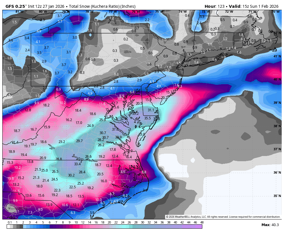
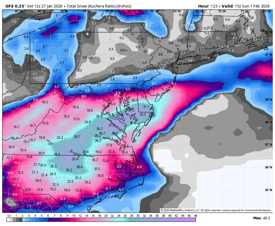
The 0z NAM was a hit. 0z RGEM looked good and 18z Euro came back W Hopefully CMC and Ukie are outliers -
Richmond Metro/Hampton Roads Area Discussion
Conway7305 replied to RIC Airport's topic in Mid Atlantic
Wow! What an insane run -
Richmond Metro/Hampton Roads Area Discussion
Conway7305 replied to RIC Airport's topic in Mid Atlantic
It is!! -
Richmond Metro/Hampton Roads Area Discussion
Conway7305 replied to RIC Airport's topic in Mid Atlantic
0z NAM is comming in HOT!! Too bad it ended when we were about to get pummeled -
The Jan 31 Potential: Stormtracker Failure or 'Tracker Trouncing
Conway7305 replied to stormtracker's topic in Mid Atlantic
BOOM! -
Richmond Metro/Hampton Roads Area Discussion
Conway7305 replied to RIC Airport's topic in Mid Atlantic
Much Better! Big shift W -
Richmond Metro/Hampton Roads Area Discussion
Conway7305 replied to RIC Airport's topic in Mid Atlantic
Exactly! -
Richmond Metro/Hampton Roads Area Discussion
Conway7305 replied to RIC Airport's topic in Mid Atlantic
18z GFS looks to hold. 12z EPS came W some. 12z CMC looked ok. Who knows…. -
Richmond Metro/Hampton Roads Area Discussion
Conway7305 replied to RIC Airport's topic in Mid Atlantic
On a positive. It stopped trending E and came back W slightly. -
Yep, it did not trend east on this run. Actually came back W slightly and rakes OBX. Still for the fish mostly. Curious to see EPS.
-
Richmond Metro/Hampton Roads Area Discussion
Conway7305 replied to RIC Airport's topic in Mid Atlantic
Euro AI did not come W….:/ Will see if Euro follows -
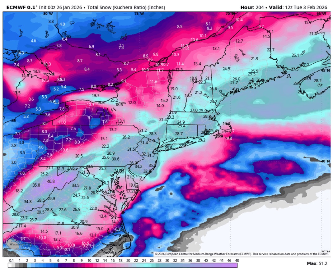
lol, 30 “ for Short Pump. It’s Euro vs GFS
-
Richmond Metro/Hampton Roads Area Discussion
Conway7305 replied to RIC Airport's topic in Mid Atlantic
West -
Richmond Metro/Hampton Roads Area Discussion
Conway7305 replied to RIC Airport's topic in Mid Atlantic
-
Hopefully it will trend W at 12z
-
Richmond Metro/Hampton Roads Area Discussion
Conway7305 replied to RIC Airport's topic in Mid Atlantic
12z GFS gonna be a BIG hit!! -
Richmond Metro/Hampton Roads Area Discussion
Conway7305 replied to RIC Airport's topic in Mid Atlantic
euro and eps have been trending east, hopefully that can correct back. -
Richmond Metro/Hampton Roads Area Discussion
Conway7305 replied to RIC Airport's topic in Mid Atlantic
Ukie is a big hit as well!! -
Richmond Metro/Hampton Roads Area Discussion
Conway7305 replied to RIC Airport's topic in Mid Atlantic
Way better then 12z runs -
What about trends on the Euro AIFS?
-
Richmond Metro/Hampton Roads Area Discussion
Conway7305 replied to RIC Airport's topic in Mid Atlantic
Wow!! Here we go again……lol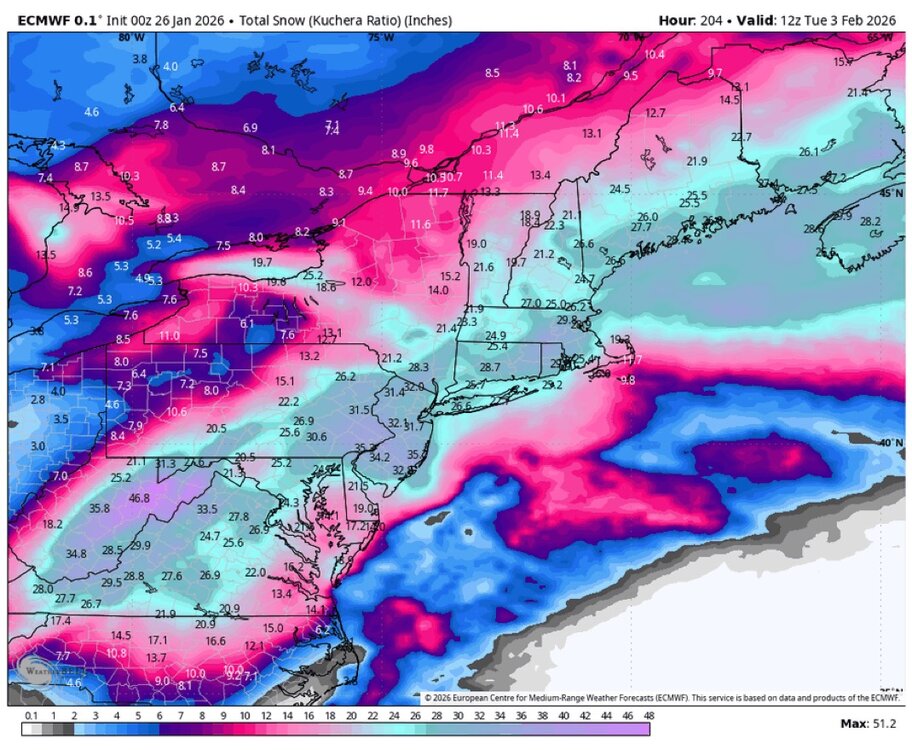
-
Richmond Metro/Hampton Roads Area Discussion
Conway7305 replied to RIC Airport's topic in Mid Atlantic
Next “potential” storm should be a more coastal Miller A. Not some hybrid overrunning storm that cuts in OH. -
Richmond Metro/Hampton Roads Area Discussion
Conway7305 replied to RIC Airport's topic in Mid Atlantic
18z Euro @ 144
-
Richmond Metro/Hampton Roads Area Discussion
Conway7305 replied to RIC Airport's topic in Mid Atlantic
I swear, I think we’ve had at least about an inch or so of sleet -
Richmond Metro/Hampton Roads Area Discussion
Conway7305 replied to RIC Airport's topic in Mid Atlantic
anyone know the total ice forecast later today or has that been lowered. Hopefully so.