Conway7305
-
Posts
915 -
Joined
-
Last visited
Content Type
Profiles
Blogs
Forums
American Weather
Media Demo
Store
Gallery
Everything posted by Conway7305
-

Richmond Metro/Hampton Roads Area Discussion
Conway7305 replied to RIC Airport's topic in Mid Atlantic
6z euro was a tick south from 0z so hopefully bleeding stopped. Will see for 12z. Every model usually follows the euro even if its lag time. -
Richmond Metro/Hampton Roads Area Discussion
Conway7305 replied to RIC Airport's topic in Mid Atlantic
-
Richmond Metro/Hampton Roads Area Discussion
Conway7305 replied to RIC Airport's topic in Mid Atlantic
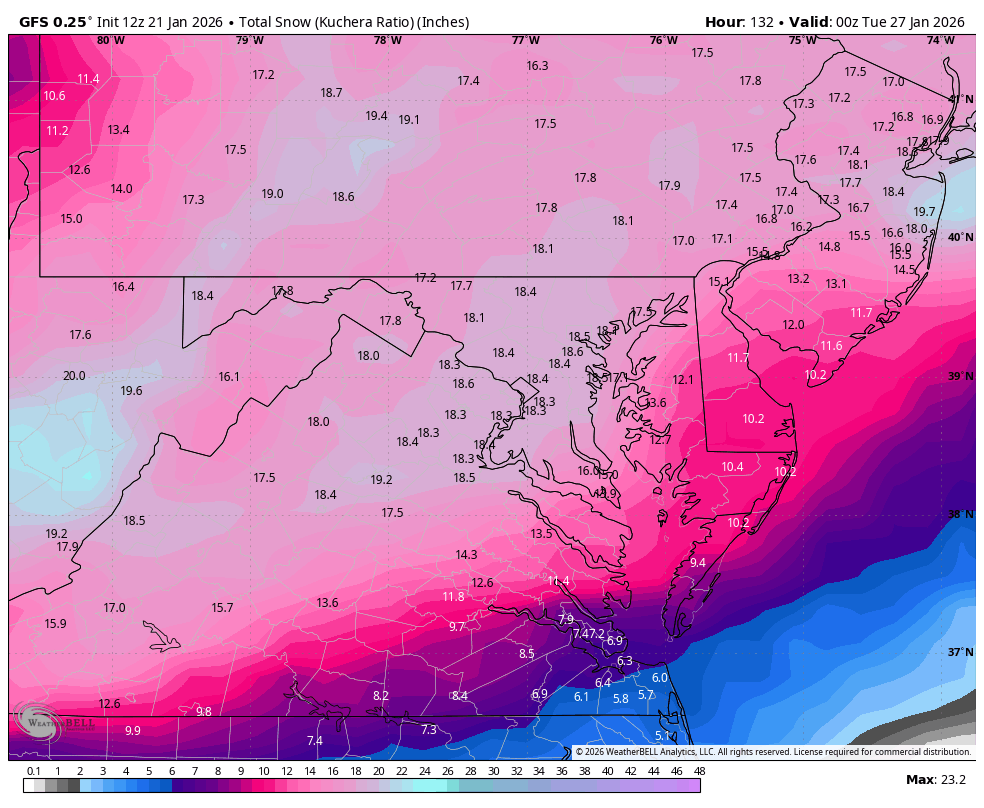
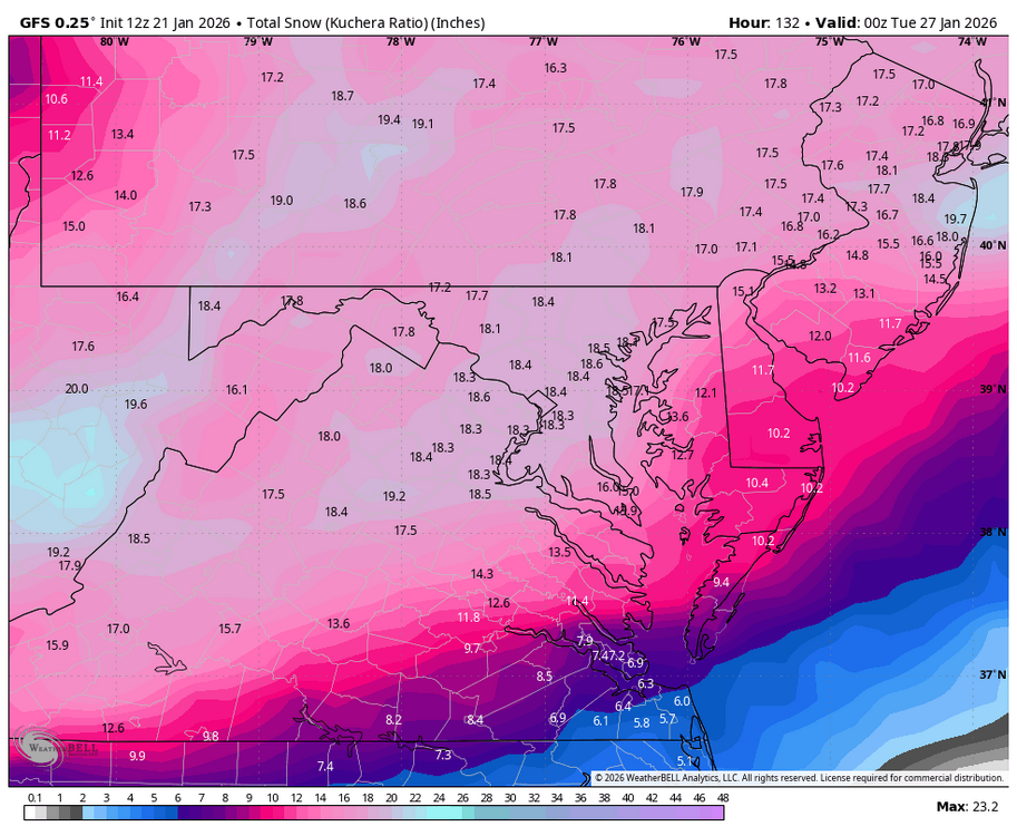
GFS ok, mixes for a bit then goes back to snow -
Richmond Metro/Hampton Roads Area Discussion
Conway7305 replied to RIC Airport's topic in Mid Atlantic
Models also don’t pick up well on CAD typically past 72 hours so hopefully we will get better idea as time get closer to storm. -
Richmond Metro/Hampton Roads Area Discussion
Conway7305 replied to RIC Airport's topic in Mid Atlantic
ICON is snow to ice. Not really putting much faith in th model. It’s all over the place and usually corrects to euro or gfs -
Richmond Metro/Hampton Roads Area Discussion
Conway7305 replied to RIC Airport's topic in Mid Atlantic
NAM is way too warm. Hopefully that will correct in time -
Richmond Metro/Hampton Roads Area Discussion
Conway7305 replied to RIC Airport's topic in Mid Atlantic
Stronger High Pressure over Montana (1039) has positive downstream effects on 6z Euro. See a small shift south from 0z. Bleeding hopefully has stopped maybe a trend south again?
-
Richmond Metro/Hampton Roads Area Discussion
Conway7305 replied to RIC Airport's topic in Mid Atlantic
Good Read https://x.com/_jwall/status/2013924395425624230?s=46 -
Richmond Metro/Hampton Roads Area Discussion
Conway7305 replied to RIC Airport's topic in Mid Atlantic
6z Euro ticked south a hair -
Richmond Metro/Hampton Roads Area Discussion
Conway7305 replied to RIC Airport's topic in Mid Atlantic
Warm nose sneaking up to NOVA. Ice sucks -
Richmond Metro/Hampton Roads Area Discussion
Conway7305 replied to RIC Airport's topic in Mid Atlantic
13.5”’14” not bad at all. -
Richmond Metro/Hampton Roads Area Discussion
Conway7305 replied to RIC Airport's topic in Mid Atlantic
Unbelievable the models just all over the place now. Was not expecting that -
Richmond Metro/Hampton Roads Area Discussion
Conway7305 replied to RIC Airport's topic in Mid Atlantic
At least there’s some southern ensemble solutions still. RVA is always on the R/S line in these setups. -
Richmond Metro/Hampton Roads Area Discussion
Conway7305 replied to RIC Airport's topic in Mid Atlantic
CMC had ICE to PA :/ -
Richmond Metro/Hampton Roads Area Discussion
Conway7305 replied to RIC Airport's topic in Mid Atlantic
0z GFS running, let’s hold the line. -
Richmond Metro/Hampton Roads Area Discussion
Conway7305 replied to RIC Airport's topic in Mid Atlantic
14” is good for RVA. Flirts with Snow/Sleet line after initial dump. -
Richmond Metro/Hampton Roads Area Discussion
Conway7305 replied to RIC Airport's topic in Mid Atlantic
Not too doom and gloom .I actually agree the N shift is real, Been analyzing the members and operations runs from 0z to 12z to 18z and there were definitely more members now bringing heavy snow to NOVA points north. However still lots showing hits here , just not as solid as earlier. Hopefully will correct back S. -
Richmond Metro/Hampton Roads Area Discussion
Conway7305 replied to RIC Airport's topic in Mid Atlantic
In 2016 we managed to stay mostly snow. Minor mixing but flipped back to snow. -
Richmond Metro/Hampton Roads Area Discussion
Conway7305 replied to RIC Airport's topic in Mid Atlantic
Here is 18z EPS -
Richmond Metro/Hampton Roads Area Discussion
Conway7305 replied to RIC Airport's topic in Mid Atlantic
Here is 18z Ukmet Image -
Richmond Metro/Hampton Roads Area Discussion
Conway7305 replied to RIC Airport's topic in Mid Atlantic
A few runs ago the euro snuck in a little bit of sleet , but then backed it down again so I think it’s gonna waiver. -
Richmond Metro/Hampton Roads Area Discussion
Conway7305 replied to RIC Airport's topic in Mid Atlantic
18z AIFS Ensembles Folks were still good -
Richmond Metro/Hampton Roads Area Discussion
Conway7305 replied to RIC Airport's topic in Mid Atlantic
EPS was still good for us. Ensembles tell the story. The operational can flip around some. -
Richmond Metro/Hampton Roads Area Discussion
Conway7305 replied to RIC Airport's topic in Mid Atlantic
“Gotta smell the sleet to get the goods”….lol stole that line from NOVA forum. We still do just as good as DC. -
I wonder if this storm could rival the 1940 blizzard that set the all-time snow record in Richmond for 21”.