Conway7305
-
Posts
915 -
Joined
-
Last visited
Content Type
Profiles
Blogs
Forums
American Weather
Media Demo
Store
Gallery
Everything posted by Conway7305
-

Richmond Metro/Hampton Roads Area Discussion
Conway7305 replied to RIC Airport's topic in Mid Atlantic
Good Stuff in Powhatan now. Moving our way. -
Richmond Metro/Hampton Roads Area Discussion
Conway7305 replied to RIC Airport's topic in Mid Atlantic
Some moderate/Heavy snow just W of Lynchburg working our way -
Richmond Metro/Hampton Roads Area Discussion
Conway7305 replied to RIC Airport's topic in Mid Atlantic
Radar filling ion nice. Some heavy stuff out West. Maybe it’s just me but the rain snow line seems way down in North Carolina. -
Richmond Metro/Hampton Roads Area Discussion
Conway7305 replied to RIC Airport's topic in Mid Atlantic
as Yup! Also here in Tuckahoe. Everything is sticking. -
Richmond Metro/Hampton Roads Area Discussion
Conway7305 replied to RIC Airport's topic in Mid Atlantic
Did they up their totals? -
Richmond Metro/Hampton Roads Area Discussion
Conway7305 replied to RIC Airport's topic in Mid Atlantic
Seen a few flakes in Short Pump -
Richmond Metro/Hampton Roads Area Discussion
Conway7305 replied to RIC Airport's topic in Mid Atlantic
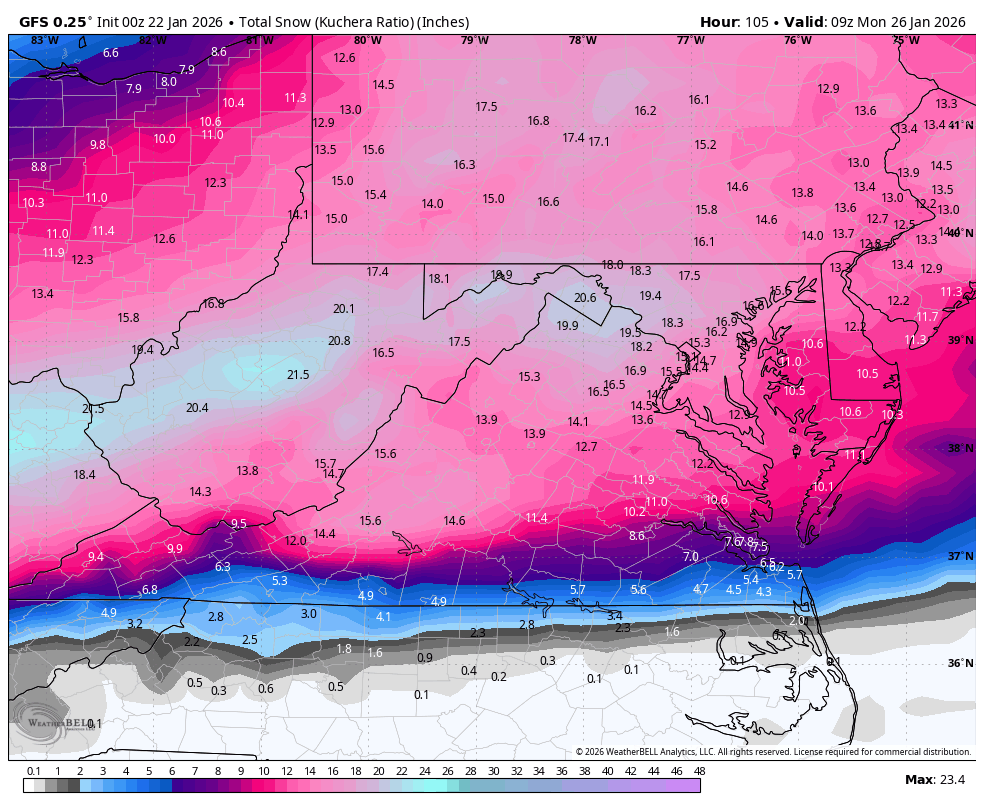
Does Kuchea include sleet. I thought it removed it. -
Richmond Metro/Hampton Roads Area Discussion
Conway7305 replied to RIC Airport's topic in Mid Atlantic
Looks like we are gonna be in a severe ice storm based off of the euro. 1.3 inches of ice is awful. Everything is still trending north. Even DC is getting significantly lower accumulations. I’ll start following the short range models now. -
Richmond Metro/Hampton Roads Area Discussion
Conway7305 replied to RIC Airport's topic in Mid Atlantic
I believe that’s the combination of two storms but I might be wrong -
Richmond Metro/Hampton Roads Area Discussion
Conway7305 replied to RIC Airport's topic in Mid Atlantic
damn -
Richmond Metro/Hampton Roads Area Discussion
Conway7305 replied to RIC Airport's topic in Mid Atlantic
Ukie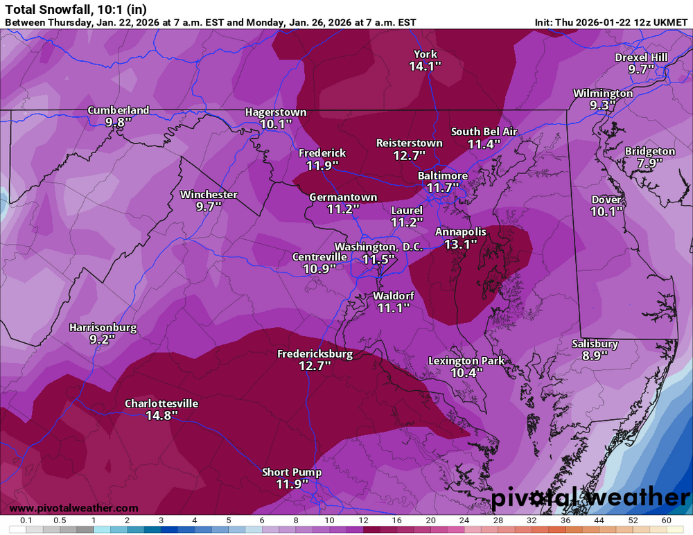
-
Richmond Metro/Hampton Roads Area Discussion
Conway7305 replied to RIC Airport's topic in Mid Atlantic
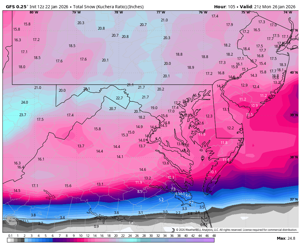
Looks like 12z holding, even better accumulations on GFS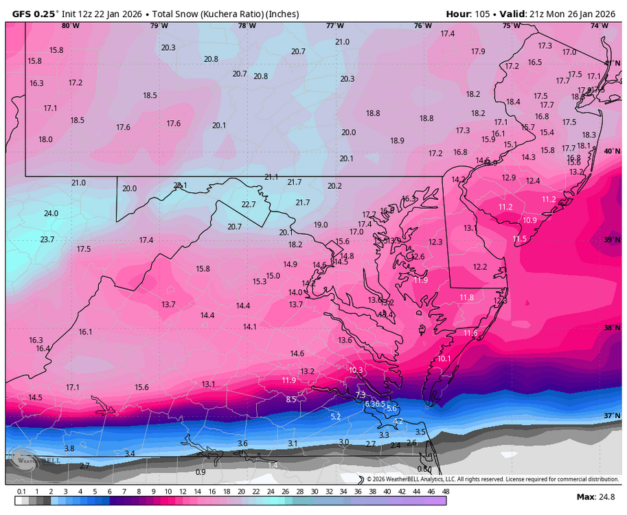
-
Richmond Metro/Hampton Roads Area Discussion
Conway7305 replied to RIC Airport's topic in Mid Atlantic
12z Nam is def colder run vs 6z. HRRR at max run looks ok as well out in Tennessee. So far good trends. 6z Euro tick colder as well. -
Richmond Metro/Hampton Roads Area Discussion
Conway7305 replied to RIC Airport's topic in Mid Atlantic
Ukie Ensembles. Not bad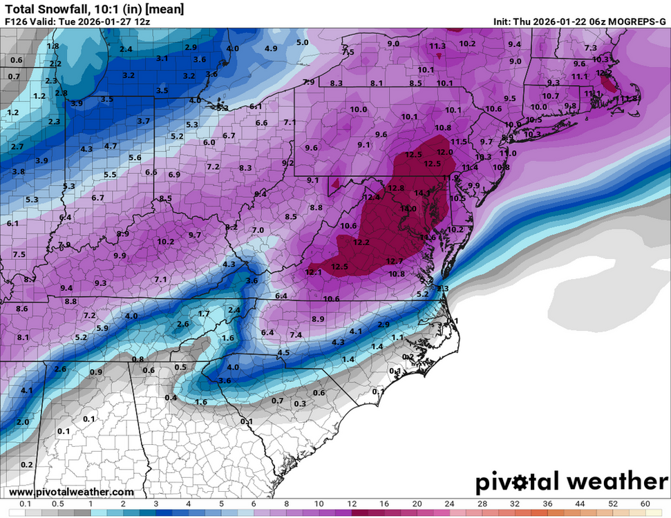
-
Richmond Metro/Hampton Roads Area Discussion
Conway7305 replied to RIC Airport's topic in Mid Atlantic
Euro ticked S 6z run. The NAM had changeover sooner, but it’s the NAM. -
Richmond Metro/Hampton Roads Area Discussion
Conway7305 replied to RIC Airport's topic in Mid Atlantic
Any variations will dramatically lower or add accumulations. Were still ok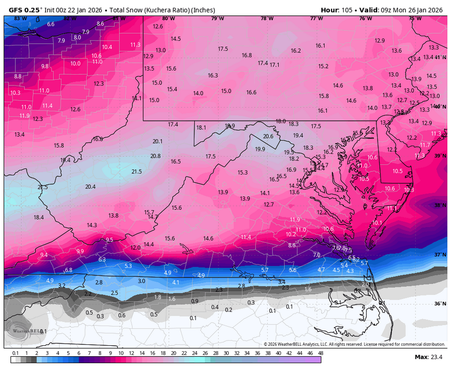
-
Richmond Metro/Hampton Roads Area Discussion
Conway7305 replied to RIC Airport's topic in Mid Atlantic
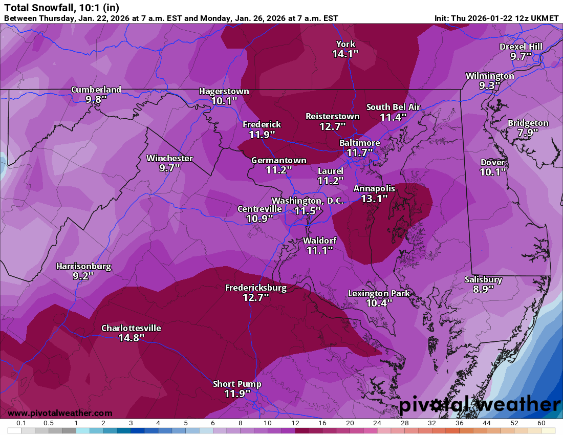
Still has us at 9-11” before changeover in RVA -
Richmond Metro/Hampton Roads Area Discussion
Conway7305 replied to RIC Airport's topic in Mid Atlantic
hmmmmm. this is interesting with 18z AIFS euro ensembles. Paints a completely different picture. I have no clue as to the reliability on the AIFS or their ensembles, but they both look great.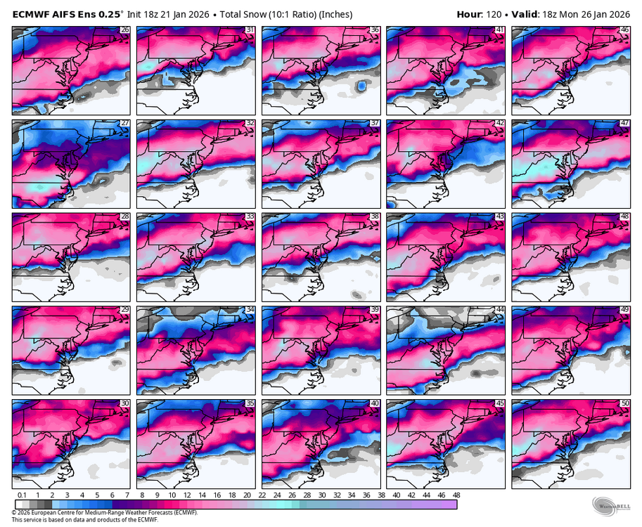
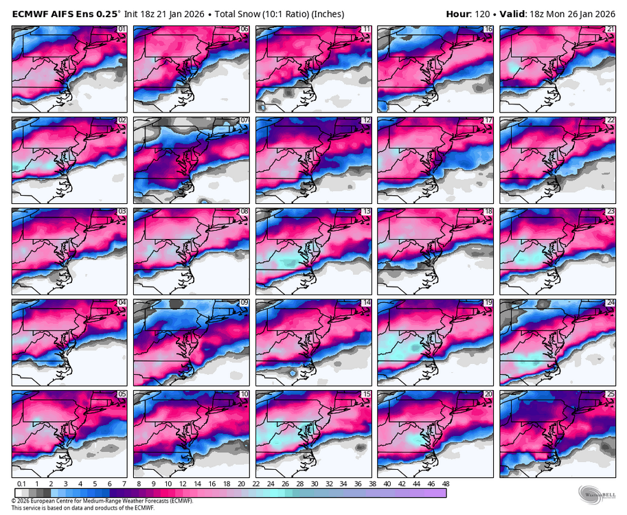
-
Richmond Metro/Hampton Roads Area Discussion
Conway7305 replied to RIC Airport's topic in Mid Atlantic
2 inches of front end snow then Ice storm per 18z Euro . It’s been trending N every single run…:/ I honestly feel like when this is all said and done. Southern PA is gonna be mixing and we’re gonna end up being mostly rain. You can’t discount the trends here. Sorry to be a downer. Have no clue what GFS sees…..lol I will stay up for the 0Z to see if the new data will change things -
Richmond Metro/Hampton Roads Area Discussion
Conway7305 replied to RIC Airport's topic in Mid Atlantic
I’m not ruling out a s shift again. Who knows. BTW. Here are the 12z Ukmet ensembles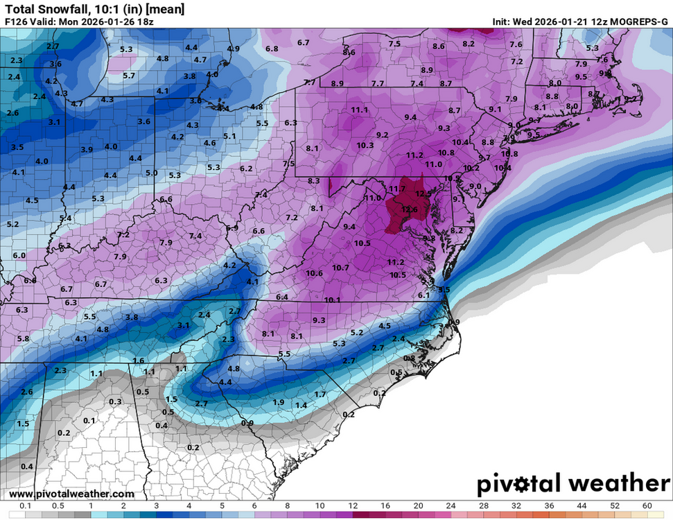
-
Richmond Metro/Hampton Roads Area Discussion
Conway7305 replied to RIC Airport's topic in Mid Atlantic
anybody know if the GFS had the new reconnaissance data ingested today? -
Richmond Metro/Hampton Roads Area Discussion
Conway7305 replied to RIC Airport's topic in Mid Atlantic
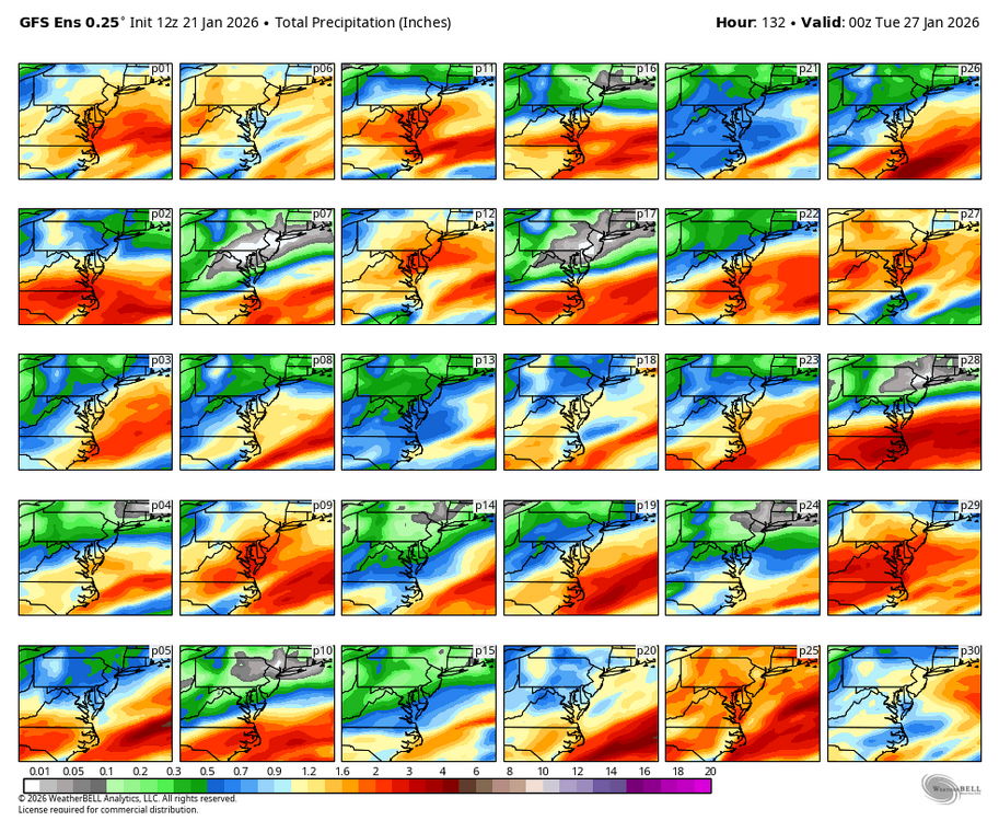
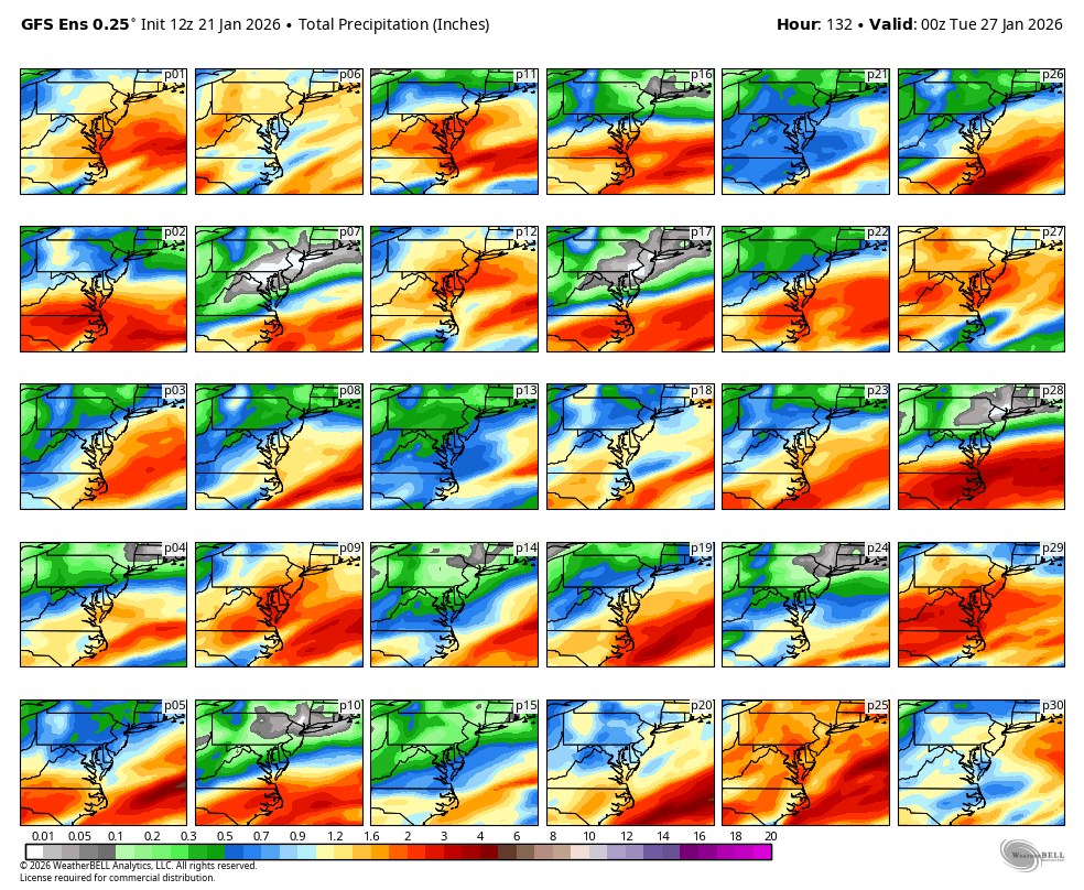
GFS Ensembles were south too -
Richmond Metro/Hampton Roads Area Discussion
Conway7305 replied to RIC Airport's topic in Mid Atlantic
who the heck knows. 18z gfs. doesn’t phase the Baja low as much
-
Richmond Metro/Hampton Roads Area Discussion
Conway7305 replied to RIC Airport's topic in Mid Atlantic
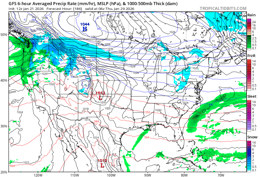
I know we’re focused on this storm but check this out down line
-
Richmond Metro/Hampton Roads Area Discussion
Conway7305 replied to RIC Airport's topic in Mid Atlantic
this is interesting. The GFS ensembles do not appear to be north at all. In fact there are a lot of southern ensemble runs.lol