

DaveNay
-
Posts
668 -
Joined
-
Last visited
Content Type
Profiles
Blogs
Forums
American Weather
Media Demo
Store
Gallery
Posts posted by DaveNay
-
-
3 minutes ago, IWXwx said:
That's the GHD III noreaster it was spitting out yesterday, just faster and more inland. Looking at this winter's pattern, congrats WI and Alek's DAB+
Weather Channel TV just said the low could be somewhere between Detroit and the final resting place of the Titanic.
-
 3
3
-
-
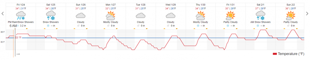
I don't recall ever seeing this narrow of a temperature band in the 10 day. Especially for the last week of January.
-
5 minutes ago, SchaumburgStormer said:
Loving the bitching pivot point action the NAM is throwing out over MBY.
Looks like a dolphin doing a back flip.
.gif.574177ce2af105fc73b92ef7c3e3cd7a.gif)
-
2
-
-
8 minutes ago, cyclone77 said:
It's looking like the Dekalb/SchaumburgStormer area could be in line for the max totals. Possibly west side of Chicago if trends continue to bump east.
As someone recently stated....
I'll believe it when I see it in the yard (both the front AND the back yard).
-
 1
1
-
-
1 minute ago, cyclone77 said:
First flakes (flurries) have arrived here. The road to 1ft begins.
Even if it takes all year.
-
2
-
-
18 minutes ago, A-L-E-K said:
Nice, would be a top 5 event of the winter here
There's only been four events....
-
2
-
-
37 minutes ago, SchaumburgStormer said:
Front has passed through. Dripping has stopped with the temp falling rapidly. Some concern as there is still a lot of ice on the trees that wind will cause issues later
On the plus side, the Magic Shell layed down by the ice will stop any blowing and drifting conditions.
-
DeKalb

Sent from my moto x4 using Tapatalk -
Just now, Baum said:
there's that storm again...........
I'm sure the only reason I remember it right now is because it has been discussed here recently.
-
 1
1
-
-
2 minutes ago, Hoosier said:
Still 32 in KC. SGF is 32 with zr and southeast winds gusting to 44 mph.

I remember sitting in my dorm room at KU (probably 2/14/90) watching transformers pop due to ice.
-

Are there a couple of radars down?
-
8 minutes ago, A-L-E-K said:
the real question, will i see flakes before it gets dark
The real question, will there be any snow remaining in the AM after the rain?
-
11 minutes ago, buckeye said:
#post0120patternchange
Rain at Mackinac Island in January. Who'da thunk it?
-
2
-
-
LOL @ Cook County

-
1
-
 1
1
-
 1
1
-
-
8 minutes ago, jlauderdal said:
i see a frozen mud situation in backyards for the chicago area, maybe some flurry action later in the week
Did 18z GFS just crap the bed?
-
1
-
-
2 minutes ago, SchaumburgStormer said:
Defo band continues to fall apart. Under and inch imby, and the remaining band isn’t going to be very impressive for anyone
All will be melted by Tuesday
-
2 minutes ago, A-L-E-K said:

This was modeled

-
2
-
-
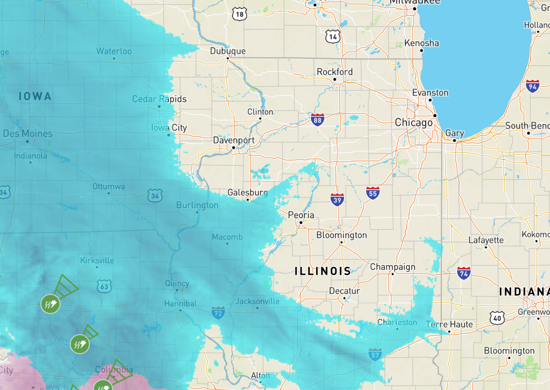
I know it's dangerous to extrapolate radar returns, but the way the band is shaping up right now, it looks like Champagne to South Bend is going to be the sweet spot.
-
2
-
-
Just now, Snownado said:
Did Raleigh move out of the Southeast?
IMO it's more mid-atlantic climo than southern climo
-
10 minutes ago, UMB WX said:
well at least we're one day closer to some more mild temps the first half of next week. Kind of taking a liking to this Mid Atlantic winter climo.
Net year begins real mid-atlantic climo for me....moving the Raleigh NC area.
-
1
-
-
5 minutes ago, michaelmantis said:
This thread will either turn into pictures of 20 foot waves on Lake Michigan or people’s brown backyards.
I can follow the dog out next time and take pictures....
-
4
-
-
5 minutes ago, Chicago Storm said:
The summary so far is guidance sucked, and an under-performance just about everywhere in every aspect...almost.
Only things that seem to be panning out are the high winds and a corridor in MO/IL/IN that did as expected with rainfall.
.Weather Channel has Cantore in Milwaukee and Paul Goodlow in St Charles, IL
Will be interesting to see if they are still doing live shots in 12 hours or if they pack up and go home.
-
1
-
-
I think it's going to rain for 40 days and 40 nights.
-
Just shy of .50" rain here so far.

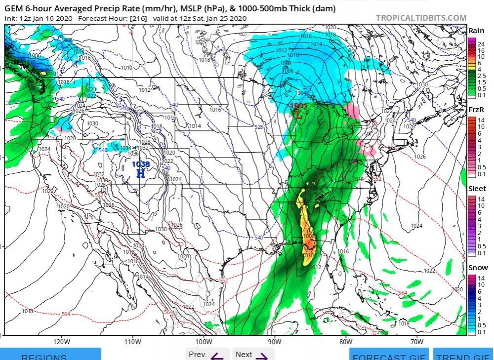
January 22nd-25th Winter Storm Potential
in Lakes/Ohio Valley
Posted
Rockford-Dubuque-Madison driftless area.