

CAPE
-
Posts
34,522 -
Joined
-
Last visited
Content Type
Profiles
Blogs
Forums
American Weather
Media Demo
Store
Gallery
Posts posted by CAPE
-
-
22 minutes ago, frd said:
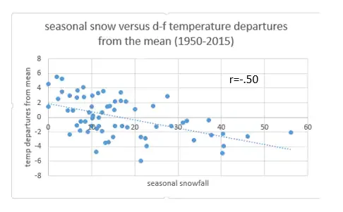
I liked this scatter diagram the best.
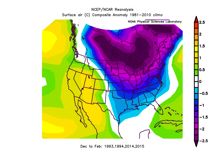
Snow lovers may want to know: Does a cold winter support a snowy winter? Your grandmother would’ve said so and that common sense answer is the right one.
Cold temperatures correlate with a snowy winter better than any of the indices I just discussed.
Below is a scatter diagram of winter temperature anomalies and seasonal snowfall.
And ofc the cold typically comes via a -AO, or in the absence of that something like 2014 with the -EPO. The -NAO (esp during a Nino with a legit stj) enhances the odds of a storm tracking underneath and just off the coast, plus keeps a N/NE wind component during a coastal storm. This is critical for significant snow in the lowlands, not so much for places further inland, esp the western highlands where there are microclimates with mechanisms like NW flow/upslope that also provide snow.
-
 1
1
-
-
Maybe the best article ever written about the various teleconnections and their importance for snow in DC, by Wes Junker.
Lots of good info and plots/graphs, but for those who don't want to take the time to read it-
QuoteThe best predictors of a snowy winter are, in this order, cold temperatures, the AO, NAO and the ONI (El Niño).
-
6
-
 1
1
-
-
I mentioned this yesterday, but this window looks somewhat interesting for a possible modest wave moving along the boundary to our south.


-
3
-
-
Light rain and 37 here. Another few hundredths maybe?
0.62" for the month.
-
8 hours ago, WinterWxLuvr said:
We also had great winters in 2013-2014, and 2014-2015 with no help in the Atlantic. 2012-2013 was decent (location dependent) and 2018-2019 was good. I don’t think those were friendly Atlantic’s either.
We have seen this discussion crop up year after year and everyone has their opinion, but for me, I like nickel and dime winters that are frequent and consistent. Not much for the big event and let’s call it a winter type winters.
2013-14 was a cool winter but also pretty rare in that it was EPO/WPO driven and the AO/NAO was predominately positive, and we had plenty of luck with timing of the smaller events. Bigger events mostly cut. 2015 was fun once we got to mid Feb, but literally nothing for more than 2/3 of met winter for the lowlands. Those winters were also back before clippers became seemingly 'extinct' which is something you have noted of late. I would guess if we see a close repeat of the big -EPO setup again(with +AO) it would be generally frustratingly dry and cold in between rain/slop with any wave that amplified.
-
5 hours ago, Negnao said:
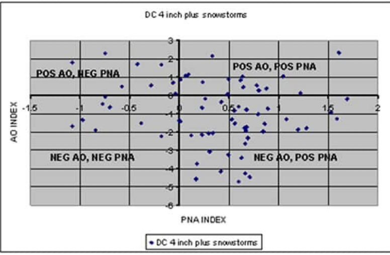
Negative PNA doesn’t work well for DC snowstorms.Should also include ENSO state to get a complete picture, and maybe EPO phase. From this plot you can clearly see the importance of -AO though.
-
1 minute ago, cbmclean said:
What is "P2" and "LC2"?
LC2 = cyclonic wave breaking equatorward
P2 = anticyclonic wave breaking poleward
-
-
26 minutes ago, psuhoffman said:
Skip to the bold paragraph if you just want the simple simple simple abridged answer…
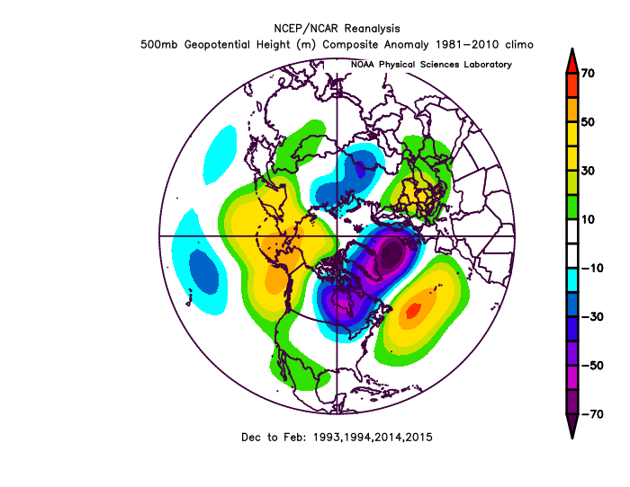
I think we’re falling prey to both recency bias and some attempts to over simplify with the “it’s the Nina” stuff I’m seeing. Let me again post the mean Dec-Feb h5 for all Nina’s the last 30 years to use as a frame of reference.
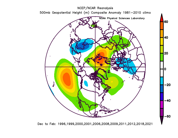
Actually a crazy -pna isn’t a common problem in a Nina. At least no more so than it can be for a time in any enso phase. You can see the tendency for lower heights in western Canada but notice on the means heights are avg in the east and the pac ridge extends into the southwest. Also our temps avg near normal in Nina’s which is actually colder than if you take all other winters but exclude the 3 modoki ninos we’ve had during that time. The 2 major correlations with a Nina are the central pac ridge and weaker STJ.
You’re seeing the smoothing of 2 different Nina patterns there though. In a Nina when there is a flatter pac ridge and no HL help we see the pac jet blast N America.
But Typically in a Nina pattern when there is a more poleward pac ridge and or some HL blocking we see the cold spread out across N America centered in western Canada but extending into the northeast. Neither typically features what we’re seeing now though!
And the current pna is bordering on possibly setting the December record. Last I saw it was just behind as the lowest pna but with what’s forecast the rest of the month I would bet it ends as the most neg pna December ever. Just that fact alone shows we’re dealing with something anomalous that we can’t just attribute to “typical Nina”. This hasn’t happened in any other Nina lol.
Now let me simplify our snow chances as I see them based on major phases. It’s the STJ. Both Nina’s and ninos can have variable longwave features and both favorable and negative features and in the last 30 years there isn’t much difference in mean temps in a Nina v Nino. Both can feature cold and warm periods. But a Nina favors more stj and we need that! That stacks the deck that if/when we do get some cold we get a big snow. Look at 1983 and 2016! And if we get lucky and get a good longwave pattern and blocking in a Nino then we get 1987/2003/2010! But that’s not all ninos either. But if you remove all the big stj driven snows from ninos the snow climo wouldn’t look any better than Nina’s! The problem in a Nina is often when we do get long cold stretches without the STJ it’s just dry. We’re too far south to get a lot of snow from pure NS storms.
Last thought: we’ve all noticed the pac base state of the last 6 years. And even the Nino of 2019 couldn’t disrupt it much. Maybe this is what happens when you add a second year Niña in top of that base state and so maybe this is the new “typical Nina” if the pac is going to remain in this phase. But we didn’t have this amount of issue with the pna last year once blocking set in. But this is a second year Niña so…
Thanks, good post. In the bolded, you meant Nino favors stj, not Nina.
And yes that is a major factor at our latitude to get bigger storms, and that's the big difference- in a Nino with an active stj we can score a big event or 2, and the winter as a whole is not necessarily even very cold. Combined with a -AO/NAO, we get the opportunity for a much more favorable storm track to maximize chances. 2009-10 was just cold enough with the -AO/NAO plus the active southern jet.
-
1
-
-
5 minutes ago, StormchaserChuck! said:
I think EPO is king, because cold air sits over land. -EPO/+NAO Winter's were pretty impressively cold,
01-02 was kind of -NAO/+EPO
A -EPO can deliver some big cold yes, but also can be dry. In conjunction with a +AO/+NAO, amped storms have the tendency to cut NW.
-AO has the strongest correlation to significant snow for the DC area.
-
Just now, nj2va said:
I’ll take a +PNA over a -NAO.
-AO is king. -NAO typically occurs concurrently. Tough to beat for cold/snow in these parts. We can do fine with a -PNA, and some of our best storms have occurred with the PNA negative, but not severely so, like we can tend to see in a Nina. I would guess the -AO/NAO and -PNA combo mostly produces in a Nino winter for the DC area, but psu is the man to confirm or debunk that.
-
1 hour ago, Eskimo Joe said:
Yikes. Credit to Chuck, he called this.
He hammered it. Beat the living eff out the dead horse. He was right. That said, a persistent -PNA is highly correlated to a Nina. One simple post would have done the trick. Didn't really need 100+.
-
2
-
-
2 hours ago, psuhoffman said:
@CAPE unfortunately the eps is predictably pulling the rug again. I say predictably because it’s not changing anything except the strength of the SE ridge. And we’ve seen that’s being supported by the pac pattern.
This is the old day 13.5

Note I’ve identified the placement of all key longwave features. The SE ridge is there but suppressed. However look at the pac. Why is it suppressing the SE ridge? We’ve still not seen any positive changes to the upstream factors.
here is the new day 13.

Nothing changes in the placement of all the key features. But as it’s getting closer and less smoother out, and the features come into better clarity, predictably the SE ridge is pumping more. That will continue to happen until something changes with the equation of the 3 features I circled in the pac. One of them has to move to shake that up. Or the equation between the Aleutian ridge and NAO needs to flip. If the Aleutian ridge weakens and the NAO ridge is the more dominant that can also work. But so long as those 3 features remain AND the Aleutian ridge is stronger than the NAO ridge we’re going to continue to see the SE ridge trend stronger and kill our changes imo.
I was looking at it as it was rolling out but had to go before the run completed. The primary thing that stuck out to me was not as good a look in the HL region, specifically the -NAO, which looks weaker and the indication of a TPV lobe underneath is absent in todays' run. Fairly subtle changes on a LR mean, but perhaps enough to allow the SE ridge to bulge northward more than previous runs. Overall not a big difference in successive runs for a day 10+ mean, so we have to watch the 'trends'. That said, I believe the expectation with the stalled MJO is that we don't see the progression we would like as soon, and the SE ridge will be tough to flatten.
-
6 minutes ago, psuhoffman said:
I’d feel better if that vortex north of Japan would move at all. It’s parked there on everything for the next 2 weeks and that feeds into the Aleutian ridge.
Earlier I had h5 animated on the 12z GEFS run and it is impressive how stable that Pac ridge is. A true block, and unfortunately it is often a fixture in a Nina. We at least need it to shift a little eastward and/or poleward at times.
-
3 minutes ago, cbmclean said:
Haven't seen much mention of the EPS lately. I was assuming it was degrading the same way.
EPS from last night- negative temp anomalies pretty much coast to coast by Jan 4.

Canadian ens from 12z today gets anomalous cold to the east coast by Jan3, but more impressive a few days later-

-
1
-
-
49 minutes ago, psuhoffman said:
The last couple Gfs runs sucked but they did get to a place we wanted at the end. If getting a huge cutter and rain to Int Falls is what it takes to shake this up so be it.
Out of the big 3 globals it is mostly the GFS/GEFS that is delaying expansion of the cold further east. Check out the CMC ens today after Jan 1. It is smiling at us lol.
-
20 minutes ago, psuhoffman said:
I’m sure many will interpret my posts as towel throwing even though I said it’s not…but one thing I’d advise caution looking at that there is with how it’s likely to adjust. That is what historical analogs suggest this should evolve too so it’s east to buy into it. But we’ve seen lately that 2 things, so long as the dominant pac longwave features are the same the trough will struggle to fight off the SE ridge and the guidance is missing this past day 10 because some members do put the trough in the east which muted the SE ridge signal in the means. But what happens as we get closer is the guidance is nailing the longwave features and the troughs and ridges just sharpen up. That little muted se ridge will very likely become more of a problem in future runs until we see something upstream change. On that I still see the n pac ridge slightly too far west, trough west of Hawaii. I don’t see anything has changed that would lend confidence it’s not again underestimating the SE ridge response.
I mentioned this in another post but the trough looks pretty locked in over the west for the next 10 days(fun times out there) but with the NAO block and slow moving vortices underneath that, we can still get transient cold and a well timed ejection of a shortwave from out west. This is happening now but too far north. That panel I posted is suggestive that maybe we get at least a brief period in early Jan where there is a bit more suppression under the block/ a little relaxation out west where a wave could track underneath and we are on the cold side. Just a big picture snapshot on a 10 day mean and it could easily deteriorate.
-
1 hour ago, MN Transplant said:
As I said, I hope you all skipped that abomination of “football” last night.
https://deadspin.com/you-ever-watch-two-teams-try-to-lose-1848251279
-
3 minutes ago, nj2va said:
Something tells me that in that setup, we aren’t talking about tracking something from 10 days out. If we can stay on the right side of the boundary, it’s more likely we’d have legit threat show up within 5 days IMO.
Probably but we are seeing hints even at this range, so something to continue to monitor. 10 days out it's just big picture, and highly subject to change with the volatility in the overall pattern.
-
12 minutes ago, IronTy said:
Does anybody remember the name of the weather blog by that guy who basically hated the world and lamented twitter weenies all the time in his posts? He had homer simpson as his avatar I think. He used to post good stuff on his website but I totally forgot what the name of it was.
Cranky weather guy I think. He stopped posting last winter iirc.
-
1
-
-
24, frosty, and cloudy here. Looks and feels like snow.

-
1
-
-
2 minutes ago, SnowenOutThere said:
Basically the MJO is stalled out which affects the pacific jet stream to not extend as much leading to a continuation of the current pattern. Though the MJO should reach where we need it to be but it might not move till early January. My question is: at what point do we say that the MJO won’t progress, as in when do we through in the towel? By New Years if the change has still been kicked down the road?
Well you don't throw in the towel. Historically a wave of that magnitude is favored to moved into phase 8, and some guidance is suggesting it may not occur until around mid month. If that is the case we will probably see some transient cold periods but the mean trough will likely remain out west.
-
1
-
-
For all the talk of can kicking, this is a pretty good look right here, and there are hints on the ops and ens runs of a modest wave or 2 tracking along the boundary during the Jan 1-5 window. Just need that boundary to be far enough south.

-
2
-
-
1 minute ago, SnowenOutThere said:
I may not be the most informed poster here but this is a bit concerning if the models continue kicking the can, or maybe the last two runs are just flukes and it will go back to a Jan 6th transition. If it does not however than we have to realize that this pattern change went from after Christmas to after New Years to now possibly mid month? By that point we might have to accept that nothing will happen if the can kicking continues.
Read the thread I posted, then dig a bit more into the teleconnections if you want to learn more about the pattern drivers. There are legit reasons behind the model 'can kicking'.
-
1
-
1
-


January Medium/Long Range Discussion
in Mid Atlantic
Posted
In this thread when there is not much to see in the shorter range, we are mostly left with discussion/conjecture centered on progression of the longwave pattern in the long range. Analysis of a LR ensemble mean plot for a given timeframe over multiple model cycles can provide indications about the evolution of the overall pattern. Big picture stuff with plenty of uncertainty obviously.