

CAPE
-
Posts
34,522 -
Joined
-
Last visited
Content Type
Profiles
Blogs
Forums
American Weather
Media Demo
Store
Gallery
Posts posted by CAPE
-
-
13 minutes ago, H2O said:
IDGAF at this point. I’ll drive NSEW to see snow. I’ll drive into the ocean to see snow
Avg annual snowfall must be higher a couple hundred miles east of me. Baroclinic zone is foo far offshore during much of winter. Fish snow. Ji was wrong about me living in the ocean, but I probably should.
-
 1
1
-
-
14 minutes ago, frd said:
Don't see that too often. I like our chances for the "CAPE" storm.
Ha they always fail, but half the fun of this silly hobby is just having something to track. A chance. After a prolonged period of 'nice' weather with really no shot, this probably is the first legit chance for a light, maybe moderate frozen event for at least part of this subforum outside the highlands.
-
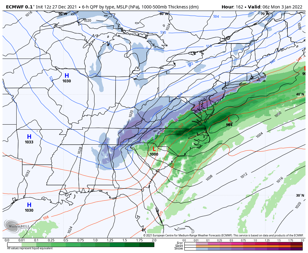
As depicted this run, pretty textbook for a moderate snow event. Notice how the Highs and Lows are in all the right places.

-
6
-
 1
1
-
 2
2
-
-
CAPE storm is still alive.

-
2
-
-
2 minutes ago, cbmclean said:
But +AO/+NAO. Can't win, even in fantasy land.
Eh, a shake up in the pattern might be good. We are damn good at failure regardless. Let the Pacific drive and hope it's not cutters followed by cold/dry. Maybe we do a mini version of 2014.
-
-
3 minutes ago, frd said:
Hmm...over your house, sweet !

Next panel is better. Lewes/Rehoboth bullseye. It will probably happen as I will be heading in the other direction.
-
1
-
-
9 minutes ago, WinterWxLuvr said:
So … it’s not gonna snow now?
Sorry I don't do snow maps.
")

-
3
-
 3
3
-
-
That vortex near the Sea of Okhotsk isn't weakening as much/as fast on recent GEFS runs. That would continue to enhance the strength/stability of the Aleutian ridge and delay the western US trough movement eastward.
-
2
-
-
6 minutes ago, psuhoffman said:
The TNH loading pattern has been killing us for a while. The fact that the gulf is on fire doesn’t help either. But I’ve also noticed it’s been harder than it should be to suppress the SE ridge from going ape the last 5 years. And I’m not talking about when the EPO is mediocre and the PNA is -4. But even when it seems like it should be a workable look the SE ridge goes nuts.
A fixture in the +TNH is an EPAC ridge, same as a Nina. Flattening the SE ridge with the current background state likely requires favorable shifts in the configuration of the NPJ, and MJO (and continued help from the NAO). Seeing a much more serviceable Pac advertised on the means in the LR but no idea if it's real yet.
-
1 minute ago, Ji said:
this is a little terrifyinglooks like a severe -EPO but still warm in the east.

-PNA!!
I start looking at op runs when we have an identifiable threat inside 7 days. Why look at advertised longwave pattern stuff on an op 10+ days out when it dramatically changes run to run. Looks less scary on the GEFS.
-
13 minutes ago, Ralph Wiggum said:
12z looks more Nina.. trailing wave getting shredded in the fast flow. Probably makes the most sense at this point with less of a transient PNA ridge popping now and more of a central USA full ridge developing and linking with HL ridging.
This upcoming period has consistently looked to feature a transient eastern trough with a ridge building right behind it on the means as the trough(temporarily) re-digs out west. The window is brief and pretty much centered on a wave forming along the boundary. Too soon to know if it will be weak, shredded, too warm,(insert other failure mode), etc, but the idea is still there on today's 12z GEFS.
-
At least I can say I have observed a few minutes of frozen in December, to go along with the few mins of flakes in November.
-
4
-
-
Sleeting in Easton.
-
16 minutes ago, StormchaserChuck! said:
0z GFS ensemble mean had +400dm -PNA, 6z has -EPO. It will be -EPO with Low underneath +PNA. We'll be cold as long as the NAO stays negative
Chuck!
+PNA
-
9
-
-
8 minutes ago, leesburg 04 said:
I just hope that those who have the intuitive feel tell us at minimum 3 times a day about that intuition

Oh its coming.
-
1
-
-
In the long range all 3 global means have a very serviceable Pacific look with the mean trough and cold directed more into the central US- and with the advertised look it would also be colder in the east. The differences are up top/on the Atlantic side. GEFS maintains a -NAO, EPS looks neutral to somewhat positive, and the CMC ens is somewhat in between, but has a colder look for the east overall. Maybe we lose the blocking for a time, but it has not done much good with the raging NPAC ridge. With improvements there, we should see more cold chances via a neutral PNA/ -EPO.
eta- one other thing of note is the PV looks somewhat perturbed/elongated in the LR, and the indication of southward displaced TPV lobes can be seen on the mean. Not a bad look for getting cold air excursions further south.
-
3
-
-
The Euro ens tracks the New Years storm well NW, then has a trailing wave along the advancing cold front Jan 2-3 timeframe. Verbatim it would be cold chasing rain but still a week out so plenty of uncertainty, and we just cant know- although most of us probably have an intuitive feel for how it might play out.
-
Looking through the GEFS members, about half imply a more amplified storm that would probably track a bit too far N/W for much of our area(for frozen) but there are others that are less amped/flatter and colder, and there are a few that imply a second wave tracking further south on the 3rd.
-
4
-
-
29 minutes ago, poolz1 said:
Appreciate it. As cbmclean said, I recall praying for the PAC jet to chill out last winter. But, our MJO phases were completely different, iirc? The never-ending hobby....always more to learn.
Cheers!
My understanding is an extended jet places the exit region further east, which favors a ridge over the western US. This is more common during a Nino, while jet retraction places an anomalous ridge further west over the N Pac, and is associated with a Nina (Chuck's beloved -PNA!) Simple explanation.
Cheers!
-
4 hours ago, PhineasC said:
Never heard of Josh Johnson... best the Ravens could find?
Too bad they didn't protect Trace McSorley, eh?
-
1 minute ago, poolz1 said:
Great point....I have been thinking the exact same thing. I see CAPE's point above but still don't quite get it tbh. Maybe a case of like everything else in life...moderation is best. As I sip on my third bourbon! lol
It's Complicated.
Firstly a -PNA isn't always a bad thing.
Jet extensions occur more in Nino, while retractions are favored in a Nina. A poleward shift is more likely in a Nina. MJO phase can have an impact, however. Don't quote me, but I think jet extensions in general are favored during MJO phases 7 and 8, so if we are in fact seeing an extension of the Pac jet (during a Nina) it is probably related to the MJO. What a surprise!
I am sipping on my first bourbon after a couple glasses of wine with dinner.
-
5 hours ago, WinterWxLuvr said:
My expert analysis says that whatever we have, we want something else.
The the last couple runs of the EPS in the LR is for you. +AO/NAO, and a neutral PNA.
-
1
-
-
6 hours ago, cbmclean said:
Been reading several items about wanting a Pacific jet extension to help shake up the NPac ridge. I was thinking wasn't it last year that we were desperately hoping for the jet to retract so we could shake off the Pac puke? So an extended jet is sometimes good and sometimes bad? Anyone with more knowledge have any insight?
The positive phase of the PNA is associated with an extension, and/or a poleward shift of the North Pacific jet.

December Banter 2021
in Mid Atlantic
Posted
Looks like Truckee has a good 3 feet of snow otg.