

CAPE
-
Posts
34,227 -
Joined
-
Last visited
Content Type
Profiles
Blogs
Forums
American Weather
Media Demo
Store
Gallery
Posts posted by CAPE
-
-
Low of 57.
Beautiful sunrise.
-
 1
1
-
-
49 minutes ago, aldie 22 said:
Well gang my time in Loudoun county is coming to an end. The wife and i are downsizing from our single family home and moving to....drumroll...to just northeast of Winchester. Target December...pray the rain snow hole disappears by the time I get out there. Oh by the way...HALF the cost

Just northeast is probably better than say.. 8 miles south. Just a guess.
-
 4
4
-
-
Low of 57.
59 currently. Spectacular morning.
-
1
-
-
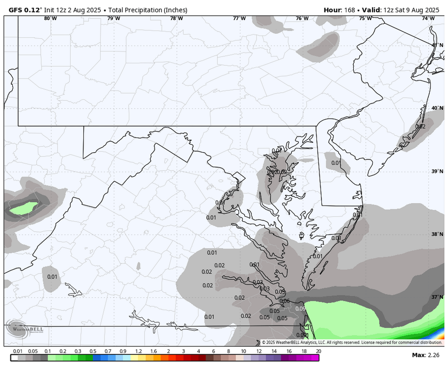
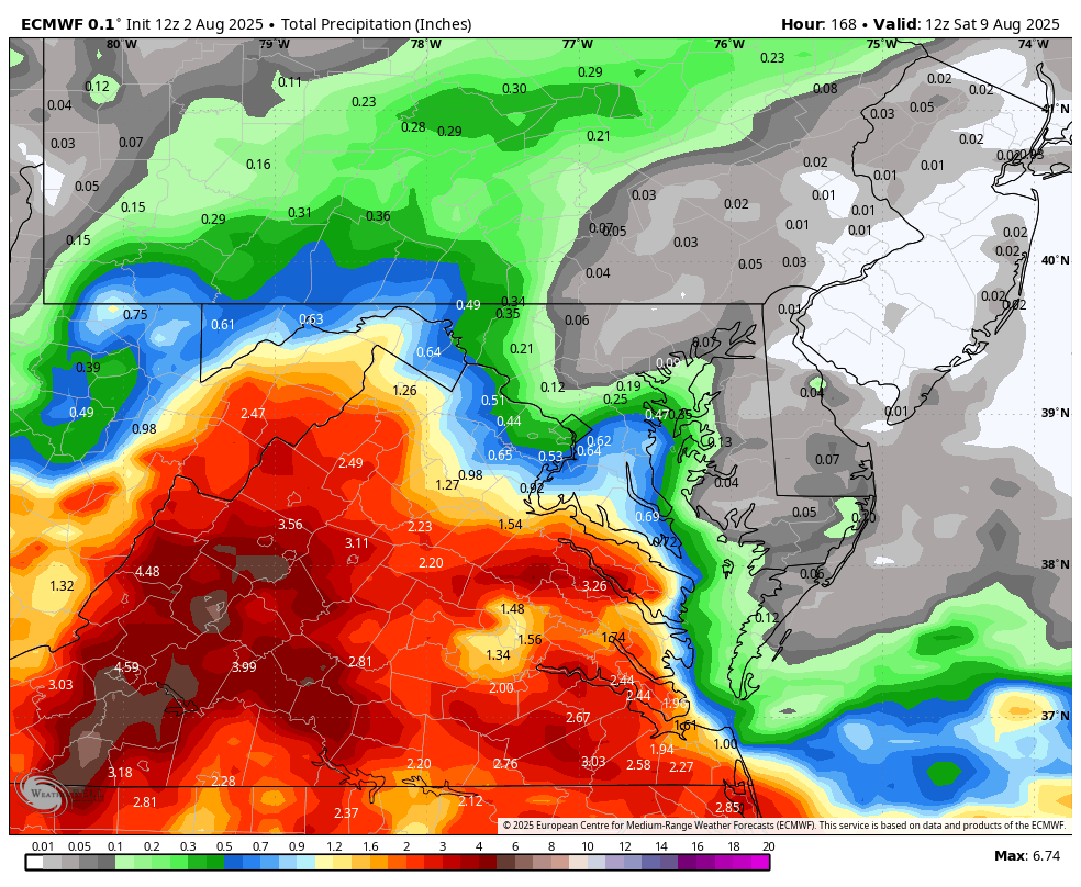
12z ens guidance- EPS and GEPS depict the more significant precip chances for central/western VA late week, with lesser amounts possible for locations further north/east. The GEFS keeps all notable precip southeast of our region.
-
4 hours ago, Weather Will said:
WB 12Z GFS and EURO precip. through Day 7. EURO can't make up its mind....

Do you ever look at the ensemble guidance? It's inherently less volatile run to run in the LR, and gives us an indication of forecast uncertainty. A single deterministic model cannot do this.
-
DFH 120 time. Limited release edition. The best yet imo.
Might not age well like the other versions because of the the dry hopping, but it's so good no one would ever let it age anyway lol.
-
1
-
-
77/57 at 4pm on August 2 in the MA. Hard to beat.
-
3
-
 1
1
-
-
27 minutes ago, dailylurker said:
I guess the front didn't make it to southern AA County. I'm in Deal and it's cloudy, damp, and humid. I needed nice conditions today.
Drier air is moving in and dewpoints should continue to drop into the 50s this afternoon.
-
2
-
-
Sunny here. 73/62
Low was 63.
-
23 minutes ago, psuhoffman said:
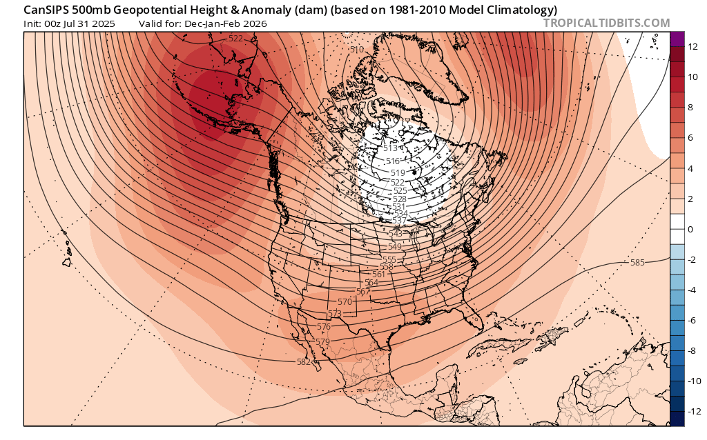
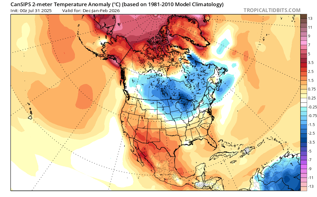
So much red
Always the case with these Climate models. I don't pay much attention to the h5 height anomalies on these tools, more so the height lines and the flow. At the surface the depicted temp anomalies give a sense of where the colder air will be relative to avg. At least there is some blue! And its nearby.
-
1
-
-
2 hours ago, Bob Chill said:
Pretty much thinking the same thing as @Terpeast and @CAPE. CFS has been mostly unwavering for months. EPS and cansips basically in the same genre. Progressive NS dominant winter = so-so in all departments. Bad luck= disaster warm wet/cold dry cycles and good luck = a heater stretch or 2 with multiple events in compressed timeframes.
Big events are possible in any winter and precip has trended up with dynamic storms because of reasons. No lr guidance is showing anything classic and I'm not expecting classic setups but you can never blanket write stuff off. Something nasty and dynamic is going to hit again one of these years. WDI keeps climbing every year too lol.
Gut guess is this winter will be warmer than last winter (easy guess lol) and snowfall/frozen will probably end up at least in the barely acceptable department.
Weak Ninas are typically the worst for our region for snow, but last winter proved decent snowfall is possible. First and foremost we need cold air, and the HL largely cooperated, most notably in the EPO domain. I cant worry myself over the PDO. It is what it is, and historically a -PDO correlates with cold ENSO, and visa versa. There are other things at play now that tend to keep it negative, but we wont get into that here. Hopefully, like last winter it at least trends towards neutral some. As I said in my post above, a key in how bad/good a Nina winter ends up is the orientation and exact location of the NE Pac ridge. If we get periods where it is poleward and located more over AK, we can get some cold to work with. Moisture and storm track are another story, and we need some luck with that.
-
9 hours ago, WxUSAF said:
Euro and GGEM has a very wet end of the week. Gfs says “what rain”?
12z GFS looks a bit more interesting with low pressure off the SE coast that gets squeezed northwestward as a sprawling area of HP in eastern Canada shifts southeastward into the Gulf of Maine. Verbatim it's a glancing blow for southeastern parts of our region.
-
Cloudy with a bit of mist. 69
Sure feels different than this time yesterday.
-
At this juncture we are probably looking at a weak Nina possibly transitioning to neutral as winter progresses. The orientation/location of the HP near the Aleutians is going to be a major factor in the winter outcome, specifically wrt cold air delivery to the midlatitudes of the central/eastern US.
New CanSIPS has the general look we want for getting cold air nearby, and the rest is getting some luck with shortwaves along the boundary. This longwave pattern has been pretty common in recent winters, so we know how this works.


-
9
-
-
2 hours ago, Maestrobjwa said:
And out goes Charlie...to the Detroit Tigers!
He was gonna go somewhere. I guess no one wanted Sugano? On a one year deal the O's would have dealt him if there was interest. Odd as he has pitched better recently and overall has had a pretty decent year. 8-5, 4.38 era..
-
0.63"
Meh. A forecast bust if that's it, but it is what it is. Good month overall. 7.55"
-
The forecast of 1-2 inches for tonight looks pretty unlikely here given current radar and the latest HRRR runs. At this point I would be happy with another half inch, but even that might be a stretch.
-
16 minutes ago, CAPE said:
Ridgely Mesonet station 3 miles to my SW picked up three quarters of an inch in 20 mins.
Up to 0.32" here in about 20 mins.
0.47" from the first batch. Need more.
-
5 minutes ago, Amped said:
Hopefully the blob stays north of Ellicott City
Could be a good test of all the improvements that have been implemented to reduce stormwater runoff.
-
13 minutes ago, Stormpc said:
O'hearn and laureano to the Padres
Sounds like the Os might get as many as 6 prospects back based on early reports.
-
1
-
-
Ridgely Mesonet station 3 miles to my SW picked up three quarters of an inch in 20 mins.
Up to 0.32" here in about 20 mins.
-
1
-
-
Mostly moderate rain here on the northern edge. Hopefully more to come later. T&L is pretty impressive though.
-
1 minute ago, SnowtoRain said:
1.10" in 20 mins, looks like you are next
Yeah the northern edge has filled in some. We shall see.
-
Just now, Chris78 said:
Uruis surprised me. He's not a FA until after next year.
Yeah but he is a utility player and his offensive numbers are down. Os don't lack young infielders. One thing I like with these trades is we are getting young pitchers in return.
-
1
-

August Medium/ Long Range
in Mid Atlantic
Posted
Looks like a really low probability of rain in our region end of the week and through the weekend . HP is dominant and any forcing is super weak. Early next week doesn't look all that promising right now either, but we shall see. The HP will be shifting eastward into the western Atlantic, so an opportunity for a disturbance to make some northward progress with with a more moisture laden flow on the backside.