
CAPE
-
Posts
34,079 -
Joined
-
Last visited
Content Type
Profiles
Blogs
Forums
American Weather
Media Demo
Store
Gallery
Posts posted by CAPE
-
-
Excessive Rainfall Discussion
NWS Weather Prediction Center College Park MD
333 PM EDT Thu May 29 2025
Day 2
Valid 12Z Fri May 30 2025 - 12Z Sat May 31 2025
...THERE IS A SLIGHT RISK OF EXCESSIVE RAINFALL FOR PORTIONS OF
THE OHIO VALLEY AND MID ATLANTIC...
...20Z Update...
Continued increases in the forecast rainfall from the 12Z guidance
suite, sufficient instability for storms, ample upper level
forcing from a strong shortwave that rapidly turns negatively
tilted, and soil sensitivity due to recent heavy rainfall have all
worked to increase the concern for flash flooding across portions
of the Ohio Valley and Mid-Atlantic Friday and Friday night.
Generally, the convection will track from west to east...so the
portion of the Slight in Kentucky really focuses on Friday morning,
whereas the portion in northern New Jersey is primarily focused on
after midnight Friday night.
Soil sensitivity to flash flooding is high as soil moisture levels
remain well above the normal for this time of year due to rain as
recently as yesterday, and not including any shower and isolated
thunderstorm activity probable around the DMV region the afternoon
and this evening. Further, possible repeating rounds of heavy rain
on Friday interacting with the terrain and full rivers should cause
onset of flash flooding to occur sooner...closer to the rainfall
start time...in these areas, making any potential flooding more
hazardous in West Virginia. Further east, urban concerns will
increase the potential impacts from flash flooding. The storms will
also occur in the afternoon and evening, during the diurnal warmest
time of day, which will add more instability for the storms to feed
on. Given all of the above, have introduced a higher end Slight
from eastern Kentucky to the Baltimore metro. The 12Z HREF suite
shows an over 50% chance of exceeding 6-hour FFGs across the DMV.
The Slight Risk area was expanded northeast across the Philadelphia
Metro and much of northern New Jersey with this update. While the
storms will impact this region Friday evening and into the
overnight, here too recent heavy rainfall will make flash flooding
more common compared to if the soils were dry. By Friday evening
a coastal low will be rapidly forming, and so instability will be
waning as the precipitation shield evolves into more of a comma
shape, with the heaviest rains along the Delaware River on the
cold/more stable side of the low. Nevertheless, remnant instability
and long duration of rainfall will still cause widely scattered
instances of flash flooding.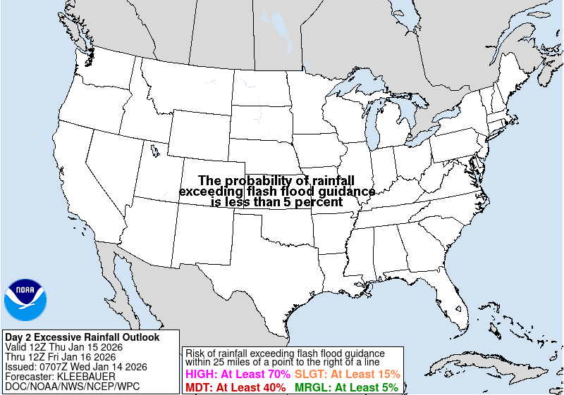
-
 8
8
-
 1
1
-
-
1 hour ago, WxUSAF said:
12z 3k NAM isn’t quite as much of an outlier as 6z, but still much farther south than hrrr or FV3 12z runs
Check out the HRDPS. Looks like a Derecho lol.
-
Based on the 6z GFS and 6z HRRR, the 6z NAM may have shit the bed. Clean up by 12z.
-
1 hour ago, JakkelWx said:
1.87"
0.10 in past hour. radar returns hanging on by a thread but ground truth is heavier. this reminds me of the back edge of a snowstorm when it sometimes re-fills in
Yeah the light rain has added up a bit.
Up to 1.42" here.
-
1 minute ago, 87storms said:
It looks kind of “flood watch”-yPer WPC much of the region is marginal for excessive rainfall.
-
18z 3km NAM looks intriguing.
-
SPC AC 281926

   Day 3 Convective Outlook
   NWS Storm Prediction Center Norman OK
   0226 PM CDT Wed May 28 2025

   Valid 301200Z - 311200Z

   ...THERE IS A SLIGHT RISK OF SEVERE THUNDERSTORMS FOR PARTS OF THE
   SOUTHEAST AND SOUTHERN MID-ATLANTIC...

   ...SUMMARY...
   Scattered severe storms with wind damage, large hail, and a few
   tornadoes will be possible Friday afternoon through late Friday
   evening across parts of the Mid-Atlantic and Southeast.

   ...Mid-Atlantic and Southeast...
   Pattern amplification will occur Friday as one shortwave trough
   progresses from the Mid-South to the southeast Atlantic/Mid-Atlantic
   coast, in advance of another wave digging southward over the Great
   Lakes.  An associated surface cyclone will develop
   east-northeastward across the Mid-Atlantic late Friday and to the
   southern New England coast by Saturday morning, while a trailing
   cold front crosses the Gulf coast, north FL and the southeast
   Atlantic coast.  Within cloud breaks the warm sector will consist of
   afternoon temperatures near or above 80 F and boundary-layer
   dewpoints in the 60s, which will drive MLCAPE of 1000-2000+ J/kg and
   minimal convective inhibition by early-mid afternoon.  Increasing
   midlevel flow with time and forcing for ascent along and just ahead
   of the front will support storm initiation with the potential for
   storm clusters and some supercells capable of producing damaging
   winds, large hail and a few tornadoes.  If wave timing and
   thermodynamic profiles remain favorable, some portion of this area
   may warrant an upgrade in later updates.
-
And the next one-

-
3
-
-
1.3"
Just light interment rain after the heavier stuff this morning. Nice event. Plants look happy.
-
3
-
-
1.15"
Almost all of that fell since 5am. Looks like lighter/more showery rain for the rest of the afternoon.
-
17 minutes ago, dailylurker said:
Yeah. Our region was in the light stuff most of the night. It started coming down harder around 3am here. I'm up to .87" so far and it's coming down pretty hard.
The coastal is getting going now. Heavier rain moving up from the S/SW in the next few hours.
0.62" so far.
-
3
-
-
1 hour ago, dailylurker said:
Classic rainy morning.
Only a tenth here overnight but steady rain the last couple hours. Looks like a soaker with 1-2" forecast for today.
-
1
-
-
3 minutes ago, nw baltimore wx said:
If ivy was money, I'd be wealthy.
Dandelions and Wild Violets for me. The latter spreads like crazy and hard to kill.
-
2
-
 1
1
-
-
46 minutes ago, RickinBaltimore said:
Three wins in a row. Hey the O's are going streaking!
Here they come!!
Only 9 games out of the final wildcard spot ( I think) with over 100 games to go.
-
 3
3
-
 1
1
-
-
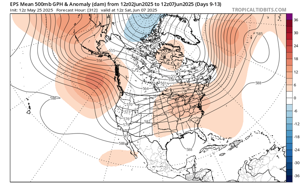
Looks like warmer times may lie ahead with a shift in the longwave pattern showing up on the ensembles.
-
7
-
-
Low of 49. Currently 65 heading into the noon hour.
Simply spectacular.
-
4
-
-
57 here currently after a high of 68. Perfect day imo. The wind is a nitpick. Felt great outside.
-
2
-
-
15 minutes ago, IronTy said:
About ten years ago I abandoned the lawn merry-go-round and let my front yard go back to nature. Planted a few trees and shrubs and now it looks like a maturing second growth forest. Very nice. Same with my back yard sans the septic field. I have a few small lawn patches left but they're mostly shade and have turned into moss which looks a good as lawn but doesn't need any water or cutting. Used to have to mow my lawn weekly but now I only break out the mower about twice a summer. Not sure how big lawns ever became desirable.
Yeah I have plenty of moss. Where it grows, I leave it, but weeds grow through it. One side of my back yard(the area over the septic drain field) gets a lot of sun in the summer, and it wont grow there.
-
1 hour ago, dailylurker said:
I've had good success with seed from American Meadows. They have native flower mixes for our area. Nothing eats the flowers and they are drought resistant.
That's exactly where I got the wildflower seed mix I planted in the Spring. Great website.
For the rest of the back garden area, I want a clover field lawn with wildflowers mixed in. I will probably just buy white clover seeds and the flower seeds from American meadows and mix it in. That link in my other post was for the picture- showing the look I want(minus the grass).
-
1
-
-
Back in early Spring I planted a bunch of native wildflower seeds at the back part of the yard near the edge of the woods. Lots of growth there now and starting to see beginnings of some blooms.
I was thinking of making most of my back yard clover + wildflowers. Tired of dealing with the grass that never survives the Summer and constant reseeding process. White clover naturally takes over in those areas anyway, so why not just plant the stuff. Low maintenance drought tolerant ground cover.
Something like this from The Vermont Wildflower Farm, although this seed mix also has some grass mixed in-
-
6
-
-
30 minutes ago, WxUSAF said:
Winds putting a damper on my weekend birdwatching for what feels like the 9th weekend in a row
I have a wild turkey who has become a regular visitor, eating the bird seed that falls from the feeder onto the ground. Makes a mess of the mulch though. They also will eat flowers, so I have been chasing it away lately. It's hard enough dealing with the deer, but Irish Spring seems to do it for the most part.
-
1
-
1
-
-
3 hours ago, WxUSAF said:
Crazy winds. This really has been the windiest year I can recall.
There is some evidence that atmospheric pressure gradients are becoming stronger, but I will decline to expound on that in this thread for obvious reasons.
-
1
-
-
16 minutes ago, Maestrobjwa said:
For me the picture is becoming a little clearer: We have a GM who is absolutely fantastic at finding young talent and building the best farm system in the league. Because the young talent was so good the team rose to contention a year quicker than anybody thought! But unfortunately...this same GM has absolutely sucked at building around that young talent. In fact he was OVERfocused on young talent, smh And then...there seem to be other issues with the way he ran things overall that are still coming to light. (over emphasis on analytics may be one of those things).
As one analyst said earlier: It's one thing to get talent: It's another to win with it. And unfortunately...Elias just hasn't been good at the other side of the equation.
He was a good assistant GM for the Astros, where his focus was scouting and player development at the minor league level. Unfortunately he seems to think that is the sole purpose of an actual GM as well. He is a failure.
-
1
-
-
Sipping on a Limited Release 120 min IPA to start the long weekend. Glorious weather the next few days. Probably wont have this again until early October lol.
-
1
-
May Discobs 2025
in Mid Atlantic
Posted
Looks like some scattered storms may fire late tonight/early AM tomorrow along and east of I-95 from SW to NE. Most guidance depicts this.