

brooklynwx99
-
Posts
5,640 -
Joined
-
Last visited
Content Type
Profiles
Blogs
Forums
American Weather
Media Demo
Store
Gallery
Posts posted by brooklynwx99
-
-
5 minutes ago, CoastalWx said:
Just keeping it real. It is what it is.
kind of incredible how bad our luck is this winter. 80-90% of the time that's a blockbuster HL pattern but the Nina is just forcing everything into the Pacific NW. I suppose patterns like what we saw in 2010-11 and March 2018 are a rare breed
not going to sleep on it, though. strong west-based -NAOs can do weird shit and I would still be surprised if there wasn't a larger storm somewhere in the March 5-20 timeframe
-
1 minute ago, CoastalWx said:
This look is meh. Thanks for pinning winter out west -NAO. Only hope is that the confluence northeast of us is enough. Otherwise it’s probably more congrats NNE. Been my worry all along.
I can't understand for the life of my why there isn't more of a confluent response over the NE US. it doesn't sit right with me, which is why I'm leaning on this correcting. like it's just not a pattern you'd expect there... you'd expect a coast to coast trough with the -EPO in place as well
-
 1
1
-
-
29 minutes ago, qg_omega said:
lol, you thought it was real?
no, just think it's funny how consistently awful the GFS is. gave me a laugh this morning
-
1
-
-
thank you GFS, very cool!

-
 5
5
-
-
5 hours ago, Maestrobjwa said:
Let me ask you this (and my apologies if this has been discussed already): Is the SER a direct result of these SSTs...or is that driven by something else? Someone answered earlier it was a nina thing, but given how strong it's been I was wondering if those warm waters were a cause.
the persistent Ninas help keep the western Atlantic warm in the same way that the insanely persistent +PNA/-EPO in 2013-2015 baked SSTs off the WC. generally the overall pattern drives the SSTs, but I'm sure there's a bit of a feedback loop going on right now that would break once a Nino forces a persistent SE trough
-
5
-
 2
2
-
-
damn. weather is some serious shit
-
2
-
2
-
-
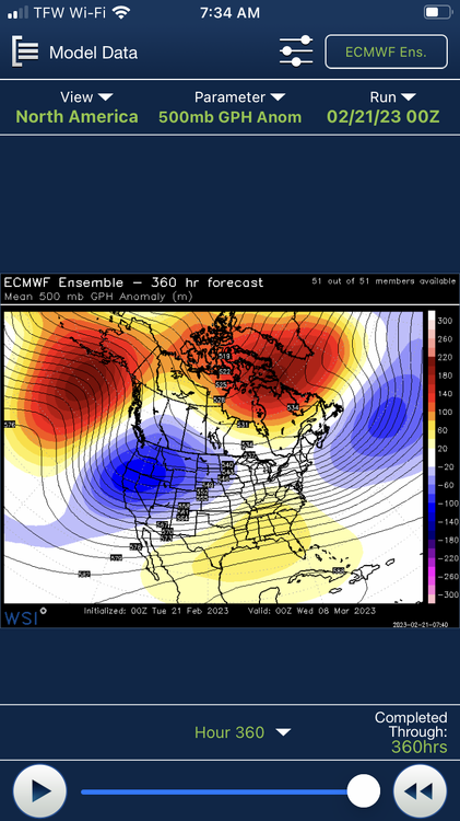
the system around the end of the month is probably our next legitimate threat. there is relatively high confidence on there being both a vigorous S/W moving through the Plains as well as a strong 50/50 in place to establish confluence. the -NAO itself isn't established, so the longevity of the 50/50 is a bit tenuous, but it may be very strong and do the job. this might be a NAO phase change event, which does lend itself to more dynamic solutions
multiple members of the GEFS and GEPS end up redeveloping a strong SLP off the coast. it's the best synoptic setup we've had in a while (not saying much), and it's approaching the 7 day barrier, so it's worth monitoring IMO
.thumb.png.1cedf9d37c7a425f4076ab08b8bd798f.png)

-
7
-
2
-
-
the system around the end of the month is probably our next legitimate threat. there is relatively high confidence on there being both a vigorous S/W moving through the Plains as well as a strong 50/50 in place to establish confluence. the -NAO itself isn't established, so the longevity of the 50/50 is a bit tenuous, but it may be very strong and do the job. this might be a NAO phase change event, which does lend itself to more dynamic solutions
multiple members of the GEFS and GEPS end up redeveloping a strong SLP off the coast. it's the best synoptic setup we've had in a while (not saying much), and it's approaching the 7 day barrier, so it's worth monitoring IMO
.thumb.png.1ac56bed865c4969237834b74c96afb4.png)

-
4
-
1
-
-
GFS made a nice shift towards a more amplified shortwave for early next week
this may lead to snowfall from the shortwave in focus, but this also will lead to more confluence for the wave over the SW US
one of these two waves is our next legit threat IMO. the stronger the first one is, the better. could lead to two storms instead of none


-
4
-
1
-
 1
1
-
-
12 minutes ago, Great Snow 1717 said:
Since November 1st how many images have you posted? And how many of those images have verified????
you could say that for anyone else here that does any kind of medium to long range forecasting
-
15 minutes ago, qg_omega said:

OP run at 384 hours
-
1
-
-
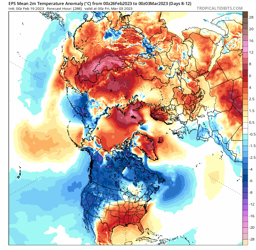
just for shits and giggles, this is what March 2018 actually looked on modeling around the same lead time. retrograding Scandinavian HP that moves towards the Davis Strait. a SE ridge actually does pop, but it is quickly flattened as the block moves westward and the ridging over the Aleutians creeps into AK

the PNA is also garbage the entire time. there is a persistent trough over the WC, kind of like what we're seeing now. however, the -NAO was able to overcome it and lead to a great stretch of weather

the main difference here is that the strength and location of the block isn't nearly as ironed down as it was in March 2018. if we do get a highly anomalous, west-based -NAO, which is certainly a possibility, then we could have a very nice pattern in place for the first few weeks of March. if the blocking is too weak or too east-based, which are also both legit possibilities, then the SE ridge will flex and we see no definitive change in our weather. I do like the AK ridge showing up on all three ensembles heading into March. this lowers the AO and EPO, leading to more cold air and a much more favorable pattern
I am inclined to believe that the west-based blocking scenario is legit due to the typical Scandinavian HP progression... we've seen it so far this winter. we shall see. I understand the pessimism, as this winter has been horrendous, but there is the chance of an exciting pattern unfolding
and just to be clear, I am not calling for anything like 2018 to happen. that was a unicorn of a month. just think that there are some similarities that are worth stating
-
8
-
4
-
-
9 minutes ago, frd said:
HL NAM doesn't look good in the long range, plus the effects of the SSWE is still very much uncertain. Might take up to 25 days to deliver a SSWE snowfall event and even if we get a West based NAO block it does not gaurantee snowy outcomes at our lattitude. Persistance needs to be broken and so far the normal crummy caveats apply.
if this goes up in smoke I'm going to put my degree in a paper shredder. retrograding blocks like this that come from strong Scandinavian highs usually work out
add in the fact that it's moving up in time and becoming stronger, as well as being associated with the SPV getting ripped apart, and I think the block is likely going to happen. I wouldn't worry about run to run minutiae when there is a west-based blocking signal this strong

-
9
-
1
-
-
18 minutes ago, SnoSki14 said:
This won't cut it for March

it's early March. it's a climatologically snowier period than much of December, that would be fine. late March I would agree, but that's not an issue at this time of year
if you have strong blocking you can snow to the coast until March 20th or so
-
4
-
2
-
-
15 minutes ago, SnoSki14 said:
The "blocking" shown on the EPS for March may only get us to near normal which by March is too warm for snow.
I'm 50/50 percent sure we won't get any more snow this season
idk about "blocking"... this is a signal for a legit west-based retrograding block. about as strong as you'll see

-
2
-
-
26 minutes ago, ORH_wxman said:
Ok that’s fair…but it’s getting established already by D10, so we’d prob need a quick reversal in guidance for it not to materialize. I don’t find that likely…but it’s still possible.
I don't see a signal like this evaporating. this is probably the best way to get a legit west-based block. it's strengthening, moving forward in time, and bolstered by the effects of the SSW
will we get anything out of it? who knows, but I would be surprised if there wasn't a large storm if this block does indeed come to fruition

-
2
-
1
-
-
7 minutes ago, Rjay said:
Looks like it wants to set up a deep wc trough imo.
a -PNA is fine when you have a west-based block like that. east-based would let a SE ridge pop, but I think the -PNA would just keep the pattern active with a Davis Strait block as depicted
-
2
-
1
-
-
18 minutes ago, CAPE said:
^Slightly ninja'd lol. Great minds.
")
I am totally fine with the -PNA there if we have a west based block. wavelengths are short enough that it's not as much of an issue as Dec 2021, for example. also, it would give a continuous stream of shortwaves to roll underneath. great pattern verbatim
-
1
-
-
the EPS now has a classic progression with the cutoff Scandi high retrograding towards the Davis Strait. I know that everyone is snakebitten, but this block is becoming stronger and moving up in time
hard not to get a bit excited when you see a retrograding block like this

-
4
-
1
-
-
21 minutes ago, CAPE said:
A bit of signal showing on the mean but a ton of spread among the members with lows all over the place. Still a ways out there obviously, but the look at H5 has cold pressing, suggesting the boundary may be to our south- a rare occurrence this winter and a necessary first step. Flatten that fucking SE ridge.


the EPS now has a classic progression with the cutoff Scandi high retrograding towards the Davis Strait. I know that everyone is snakebitten, but this block is becoming stronger and moving up in time
hard not to get a bit excited when you see a retrograding block like this

-
10
-
1
-
-
this is a pretty classic progression with the cutoff Scandi high retrograding towards the Davis Strait. same way we got that December block

-
2
-
-
3 minutes ago, CoastalWx said:
That’s what we’ll need though. It’s gotta be a good one building SW. I’d also want to see this continue on multiple runs.
i agree with you. was just being sarcastic
good to see that typical response to blocking here and not that SE ridge crap

-
3
-
-
1 minute ago, CoastalWx said:
One run lol. But man that block gets nuts on the EPS.
nah it’s not happening because persistence yadda yadda yadda we’re all just weenies
-
1
-
1
-
2
-
-
1 minute ago, Ralph Wiggum said:
Couple of discrete threats seem to be popping up. Probably going to want to start threads to avoid any confusion here

nah. base state. no more snow
-
1
-
1
-
4
-


.png.86171021c65771772711c4d48b0a9f52.png)

.png.3ffe7a0af6206a58c860531e3e29f867.png)


February 2023 Obs/Discussion
in New England
Posted
eh, I've never liked this morning's snow. BL temps are so trash