

brooklynwx99
-
Posts
6,229 -
Joined
-
Last visited
Content Type
Profiles
Blogs
Forums
American Weather
Media Demo
Store
Gallery
Posts posted by brooklynwx99
-
-
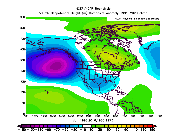
I'm not sure how many times I have said that 1972 and 1982 are legit analogs while ALSO stating that those Modoki years might be worth considering, as the WPAC warm pool both diminishes the coupling of the Nino and shifts forcing west. nobody is sure that this winter will be severe... nobody has even said that besides known Twitter hacks like JB
it's really not that ridiculous of a concept. in fact, I would say that it's more ridiculous than postulating that pretty much every single piece of seasonal guidance is dead wrong and that we're just going to see a classic EP Nino. like, just because of raw ONI without taking anything else into consideration, like solar, QBO, and how the rest of the Pacific is influencing ENSO
nobody really knows what's going to happen... we've never been in this climate before with a WPAC that hot and a developing strong Nino. the declarative statements are ridiculous and this may be a year where thinking outside the box is helpful. just a thought
-
 3
3
-
-
14 minutes ago, griteater said:
It’s just thoughts and ideas being thrown out raindance. No one knows for sure what’s going to happen
nah, tropical forcing is a crutch that weenies use to forecast because they're sad that it might torch in December. we should know better than that
-
 5
5
-
-
14 minutes ago, 40/70 Benchmark said:
Well, the MEI and RONI were noth high that year bc the west PAC was cool...like all of the classic intense el nino events. If it ends up like that, then sure.
if the queen had balls...
-
also just keep in mind that I'm really not that biased when it comes to seasonal forecasting. I was down on last winter as a whole from the get-go aside from some possible December blocking (which did occur). pull it up if you'd wish
-
3
-
-
also, saying that there can be spells of Modoki forcing later in the winter isn't wishcasting... there are reasons for why that would occur, and every single seasonal model besides the CFS is banking on it. the western lean to the forcing has been happening all summer
sure, they could ALL be wrong, but not acknowledging that is like seeing a -PNA/+AO/+NAO and saying that there's a better than normal chance at a HECS. it's kind of silly to laugh in the face of the mounting evidence. it's not like all guidance is showing those parameters (classical forcing, major E Canada ridging, +NAO) and people are trying to will a more favorable pattern... it legitimately seems more likely than not right now that the back end of winter has the potential for a prolific pattern to develop
-
4
-
-
17 minutes ago, snowman19 said:
One thing is for sure, IF we get to early November and there’s a super Nino or one is imminent and IF there’s canonical El Niño forcing, I’m going torch. I don’t care what the MEI or the Macaroni index or the CANSIPS or any other seasonal model says at that point given those 2 circumstances. Again, IF. I remember all the people who got burned really bad going for a cold winter back in 15-16 with their “west-based super Nino” and “west of 1997” wishcasting (ie. JB, Judah Cohen, etc). 15-16 was one lone snowstorm in a sea of unending warmth. As far as snow, I won’t go there because one rogue, lucky, thread the needle storm can dump in super Ninosif the MEI/RONI are much lower than the ONI, I can near guarantee that there won't be canonical Nino forcing near 140W. it would be farther west
the two happening at the same time would basically contradict each other
-
2
-
-
2 hours ago, qg_omega said:
Warmest winter ever looks very likely
looking at ENSO… no changes
-
13 minutes ago, George001 said:
It’s not irrelevant, yes that’s warmer than other datasets but the weekly data has enso 3.4 at +1.2, that is still very impressive for this time of the year. The nino is on track to become strong by September, and super by November.
the forcing is going to be more important than the raw ONI... that seems to have become clear at this point. besides, the WPAC warm pool likely leads to a MEI that's significantly lower anyway. this is already evident
a 2.1C Nino might only act like a 1.7C Nino. there is a big difference. I think we'd need to get to 2016 levels for this to actually act like a super event
-
1
-
-
again, years like 1982 and 1972 still need to be considered at this point, but it seems like we're leaning towards a more favorable outcome than not. we're almost into September at this point. to deny that would be like seeing a near-unanimous blowtorch and saying "well, they could all be wrong and it could still be quite snowy!"
that person would be called a weenie, and rightfully so. not sure why when it's the other way around, everyone gets all skeptical
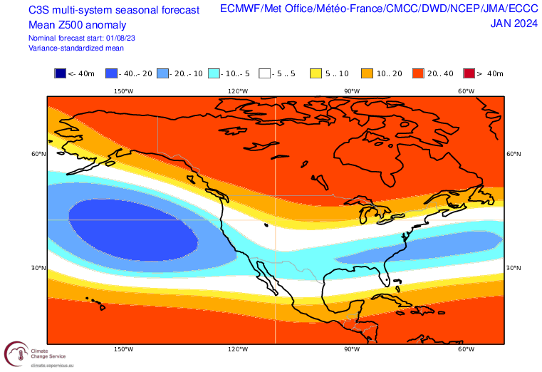
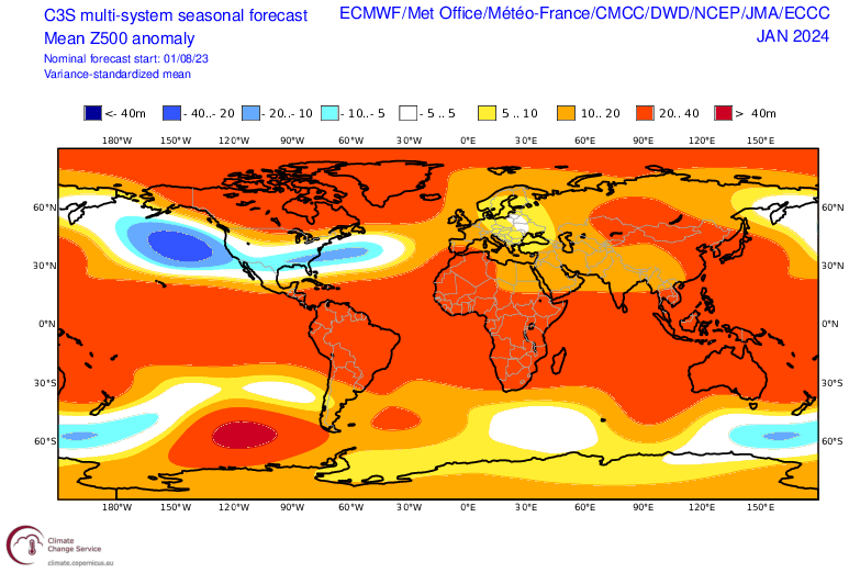
I would say if modeling still looks like this by the early October runs, years like 1986, 2002, and 2009 will be serious considerations. for now, they're just more years to think about until everything shakes out through the fall
-
7
-
-
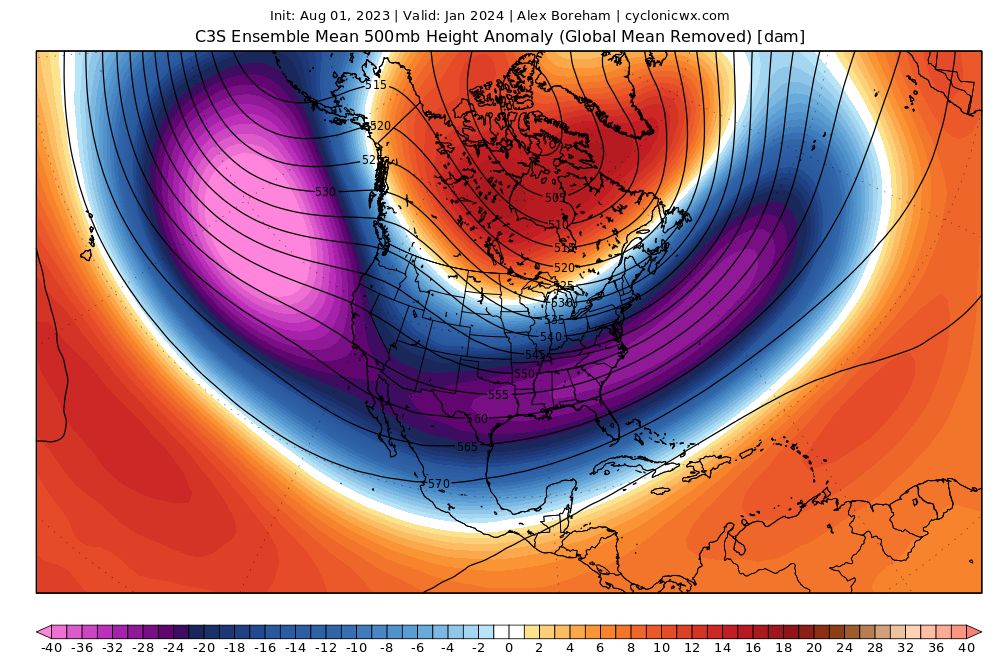
also, if we're going to be completely honest with ourselves for a moment, which set of years does the C3S look like? the moderate to low-end strong years with Modoki-esque forcing, or the classical super Ninos?
not even trying to say which scenario is more likely to be correct, but I'm not sure how you can say it doesn't look more like the former than the latter
my assumption is that the farther west forcing is leading to a farther W Aleutian LP, which helps height anomalies out west remain more neutral than negative and increase blocking. blocking will be a key feature this year, and the -QBO and ascending solar activity close to a max leans towards more blocking than less

-
5
-
-
2 hours ago, 40/70 Benchmark said:
I don't think its going to be frigid. I agree with that, however, it depends where the forcing is in terms of the PNA because if its west of about 160W, then the GOA low is going to be further off of the west coast.
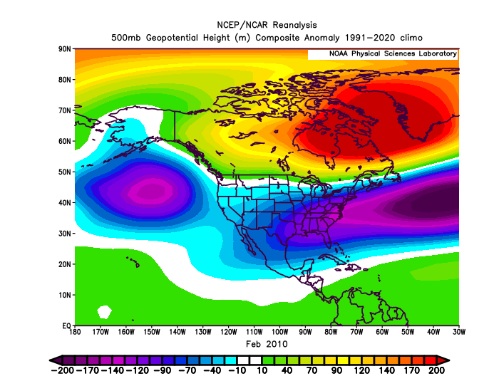
i mean, looking at 2010, one could envision the "flooding with Pacific air" that would occur... look at how far east that Aleutian low is. basically in the GoA. that obviously did not happen. blocking + split flow FTW!
-
1
-
-
5 hours ago, snowman19 said:
Region 3.4 is obviously going to warm a lot (very likely become super) over the next few months but IMO this event stays a classic Eastern Pacific/EP El Niño right into this winter. One of the big factors I think that prevented this one from evolving into a more Modoki or west-based event is and has been the very persistent -PMM. The -PMM has been strong and firmly entrenched since last fall and I believe is one of the main reasons why this event has remained so east-based. Had the PMM flipped positive I think the way this event would have developed and configured itself quite a bit differentlyI don’t think we’re going to need this to become a classic west based event… basin wide will be fine for most intents and purposes
i’m expecting a warm start, though
-
1
-
-
that should lead to the trickling west of the greatest SST anomalies, leading to a more basin-wide Nino
-
3
-
-
2 hours ago, 40/70 Benchmark said:
Great consensus. ONI can be 4.2 for all I care, if it looks like that.
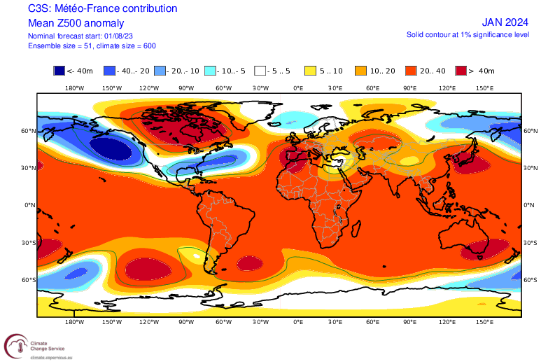
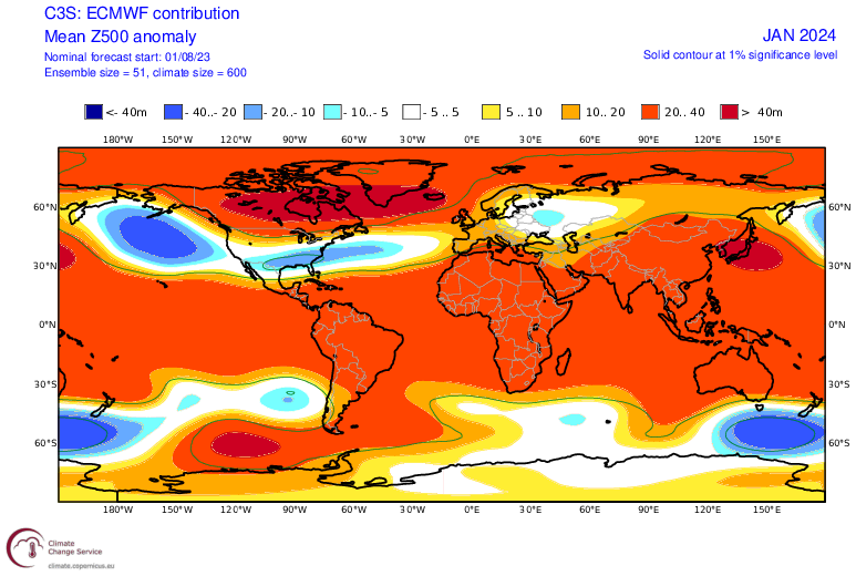
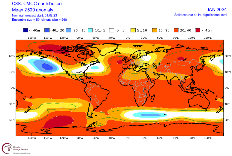
this is the super ensemble mean… sign me up
-
5
-
-
3 minutes ago, snowman19 said:
If the November runs show the exact same forcing then things will be interestingI know, I really don't know what to think here. 95% of the time, a Nino that strong is a complete torch, but there are factors that we've never seen before
I'm like the opposite of last year... 65% optimistic and 35% pessimistic. we'll have a better idea once into the fall
-
1
-
-
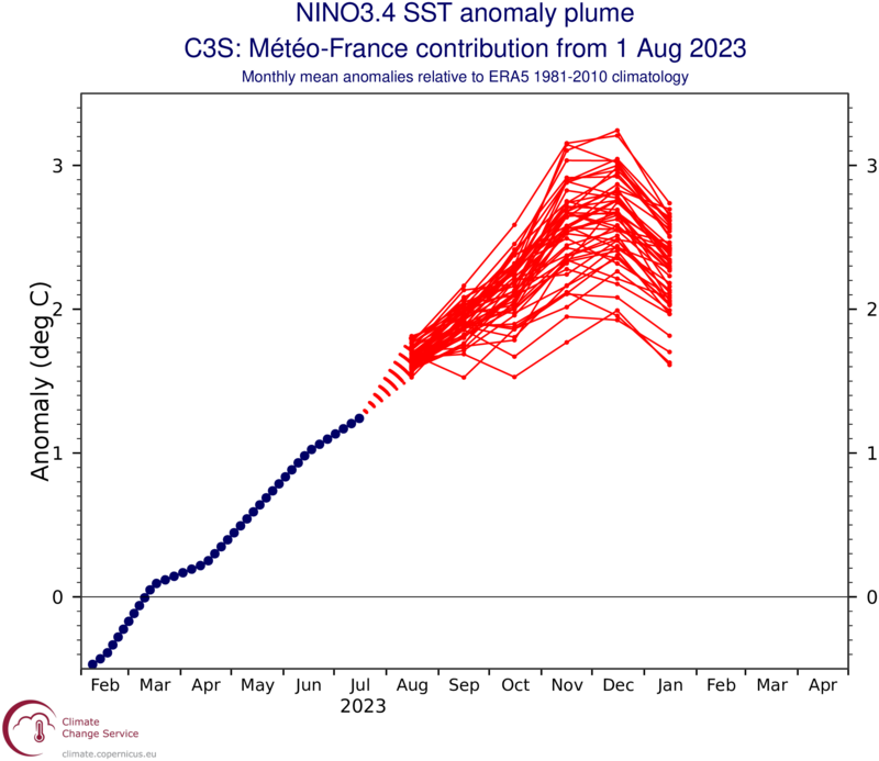
I mean, for the sake of argument, the French model has the Nino peaking at like 2.5C and still has a very favorable EC pattern. I don't think it's a coincidence that the majority of seasonal models are showing this regardless of if the raw ONI gets above 2C... there is more at play here
-
4
-
 1
1
-
-
25 minutes ago, snowman19 said:
IMO the forcing moves east by December but that’s a wait and see obviously. And if I’m a betting man, the CANSIPS and UKMET show a super El Nino on the next updates like the Euro, JMA, POAMA already do. The CFS is also warmingthe CanSIPS, JMA, ECMWF pretty much have one, but they still look favorable due to where they have the greatest forcing. the raw ONI isn't as useful as it usually is here
call these fantasy model projections all you want, but this is not what a typical super Nino looks like by any stretch. the WPAC warm pool is likely the reason for that... the MEI is likely closer to 1.3-1.7 and the forcing is likely dragged west as discussed ad nauseam by this point

-
2
-
-
the thing is that the raw SST anomalies have almost zero impact at this range
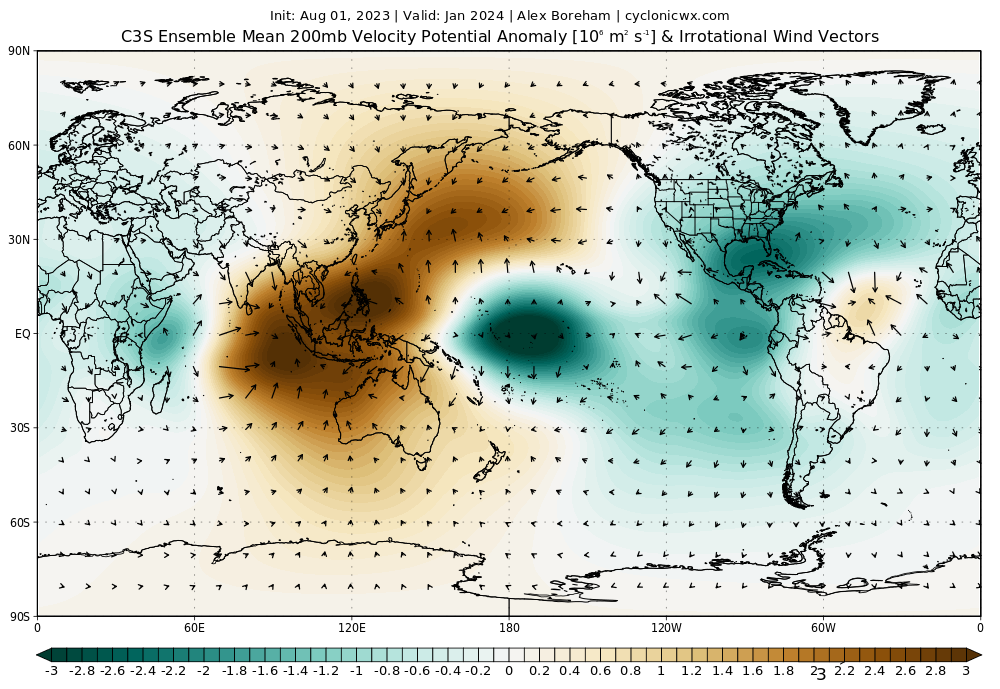
the forcing has remained far west, and this is going to become basin wide anyway. not sure what the EP circle jerk is about right now. it’s kinda pointless
-
BEASTLY EP NINO with a MEI of +0.3
give me a break
-
in terms of MEI, the new reading for JJ came out at +0.3
1997 had a MEI for those months of +2.1, 1982 was +1.9, and +1.7
2002 was +0.4, 1986 was +0.8, and 2010 was +0.4
this year literally has a lower MEI than those moderate years and isn't in the same galaxy as the super years listed above. hence my skepticism of a super Nino blowtorch this year. this doesn't take the location of the forcing into account either
-
3
-
-
54 minutes ago, snowman19 said:
In your hypothetical scenario yes, it would make things interesting possibly even with a super El Niño in place. However, I’m not so sure the WPAC will look exactly like it does now by December. Once the +IOD forcing really gets going I think the whole complexion changes out that way. All we can do is watch. That said, if we do in fact see a trimonthly ONI of +2.3C for NDJ, I still would not go with a cold winter, gotta agree with Griteater therenear normal is totally fine if there's blocking and a potent STJ if you're looking for big snow. doesn't have to be all that cold. Feb 2010 and Feb 1983 are good examples of that
-
1
-
-
1 hour ago, George001 said:
I guess it could be different, but based on how previous east based ninos and super ninos behaved I am concerned. Betting against historical precedent expecting things to be different this time usually doesn’t work out. This is true for most things. I hope im wrong, but I don’t like our odds of having even an average winter never mind a big one this year.
but this is literally different than every nino in history. historical precedent isn’t as meaningful as it usually is
-
that does NOT look like a classic EB Nino. no idea what he’s talking about
-
3
-
-
34 minutes ago, Eskimo Joe said:

i’m not even sure what he’s getting on about here… the Nino becomes basin wide on the C3S and forcing remains near the dateline. this would work well once into Jan and Feb. weird tweet
-
2
-
El Nino 2023-2024
in Weather Forecasting and Discussion
Posted
the record breaking rain is also from a highly anomalous track from a major tropical system. not sure how a seasonal model is supposed to pick up on something like that