
baroclinic_instability
-
Posts
7,869 -
Joined
-
Last visited
Content Type
Profiles
Blogs
Forums
American Weather
Media Demo
Store
Gallery
Posts posted by baroclinic_instability
-
-
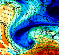
This storm is hauling quite a stratospheric intrusion. It just looks absolutely disgusting on WV.
-
Good discussion thewxmann, CUmet, Fred, tornadotony, etc. Going to be an interesting forecast for tomorrow no doubt. I don't think large convective cold pools will be a large worry by the afternoon in this flow regime and the strength of the low level theta-e inflow. The bigger questions, imo, seem to be on the synoptic scale flow and the way the models handle the upper pv anomaly and how it ejects north tomorrow afternoon and evening and the associated upper level jet configuration and associated mesoscale circulations/low level mass response (and subsequent hodograph curvature). I wouldn't be surprised if SPC holds on a high until tomorrow when some of the synoptic and subsequent mesoscale forcing details are better known. That said--seems that a high risk will be highly possible over portions of TN and northern AL at some juncture.
-
The hi-res models are all over the map right now, with the HRRR and SPC-WRF showing considerable morning convection pretty far south, while the RUC has nothing.
I don't think the RUC will be right.
-
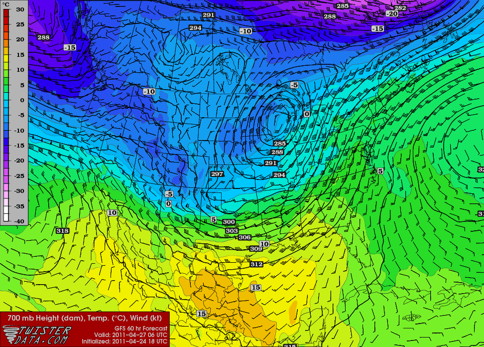
GFS just bombed this run with the northern stream upper low displaced farther W allowing for more growth of the secondary main impulse Wednesday. Main result is even stronger mid level mass response and a slightly larger occlusion/dry slot, as expected. The hodos are almost unrealistic.
-
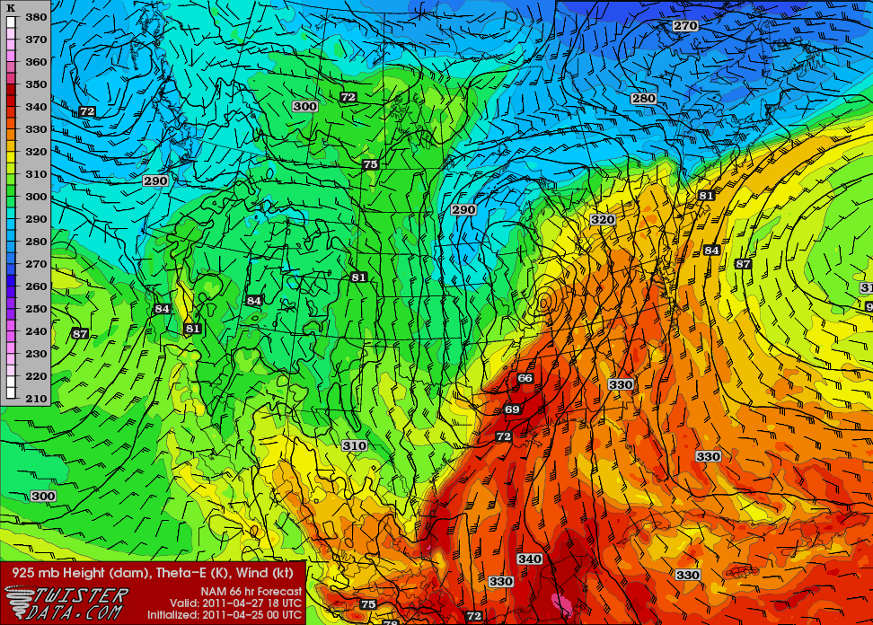
The NAM shows the potential for separation between the northern stream upper low and the southern stream anomaly with vigorous low level WAA associated with the incoming anomaly nearly creating its "own" ridge and decent separation between the synoptic lows.
Should such a scenario unfold it would undoubtedly be a historic tornado day verbatim NAM with locally backed wind fields in Tennessee and favorable low level moisture fields through almost the entire warm sector. Some of these wind fields progged by the guidance are just off the charts. Of course this would all be highly dependent on the strength of the dynamic tropopause--currently not something that will be well forecast--but the potential on the high end is something that I have never seen.
-
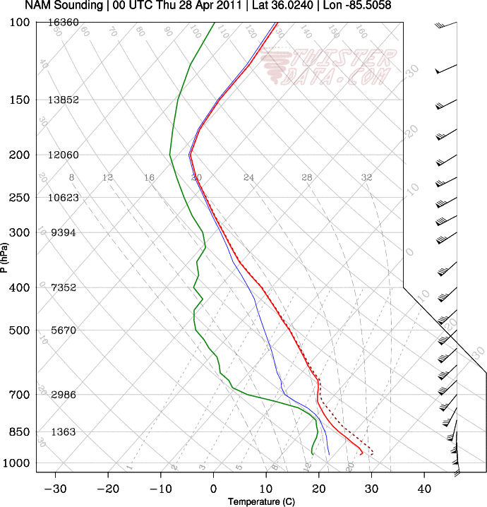
Oh you are talking about that NAM meso low that formed? Yeah that definitely was convectively induced, although it is interesting that the other models all show it. Might be something to monitor the potential of as we move through next few days.
Yeah I was guessing that was where thewxmann pulled the crazy soundings. I saw those too earlier--interesting to see if/how that feature develops.
-
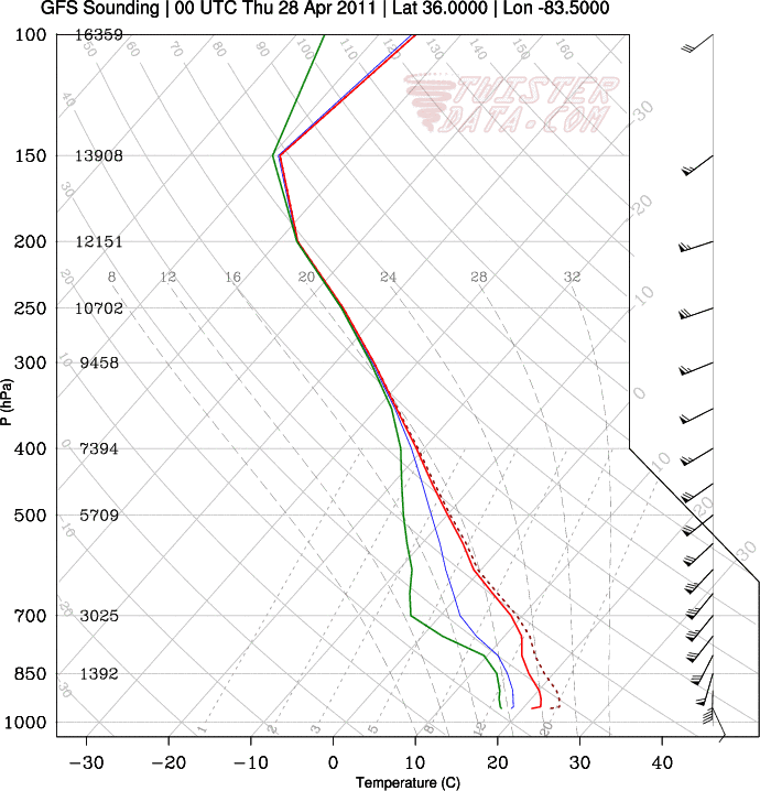
Obv convective feedback induced, but that 75kt at H85 is nonetheless impressive. 1000 m2s2 0-3 helicity to boot.
I've just never seen a hodograph that was literally "off the charts" on twisterdata like that.
I don't think there is any "convective feedback" here. Typically convective feedback is produced by overcooked convection--usually in situations with massive CAPE fields and weak shear. Old GFS displayed that when it tried to develop sub-grid scale convection under those scenarios. Classic convective feedback is a mass amount of unrealistic latent heat released by the models in the mid-troposphere which then unrealistically warms the mid levels and cripples the dynamic/thermal fields. NAM/GFS had this on full display during the Groundhogs Day storm. The old GFS bullseyes in the VV/vorticity fields were another example.
-
Amazing shear, but not a terribly high amount of instability in the sounding.
It is propagating along the warm front--you can see it in the theta-e fields. It is definitely feeding off the moist inflow. It is definitely convective in nature--no other way to explain 90 kt 850 wind fields. Oddly enough Euro, CMC, UK all suggest this type of feature.
-
lol... off the charts anyone?
Yeah I saw that too. Euro, CMC, UK and NAM all suggesting some sort of mesoscale complex rapidly propagating northward associated with that low amplitude leading wave ahead of the main anomaly overnight Tuesday into Wed and some sort of freak nasty theta-e inflow. Honestly never seen soundings or wind fields like that before.
-
What a complicated setup for each day through Thursday. Each event will have a cascading effect on both the synoptics as well as the storm environments. Not an easy set of forecasts for SPC or the local forecast offices.
-
Yesterday's runs... while having a very impressive synoptic system... were very forced in a linear fashion for Wednesday. Upward velocities were extremely strong and with a very linear configuration. This, combined with the low-level jet axis being just ahead of the surface boundary on yesterday's runs... restricting the low-level convergence to just ahead of the surface cold front... really screamed a linear storm mode. With this lower amplitude trough configuration, we have trended toward a situation where low-level convergence associated with the western side of the low-level jet is spaced significantly ahead of the surface front... and the upward velocities on the synoptic scale are also more spaced out and subtle. Also, while this won't really back the surface winds toward a southeasterly direction... we're seeing the 850-mb winds trend more SSW to SW, overtop the due south surface winds... which is a more classic configuration for our big tornado days in this part of the country. We often don't see events with a SE sfc flow work out because of the trajectories of the low-level air mass. In fact, all four of Alabama's F5 tornadoes in history happened with surface winds ranging from due S to SW... and an 850-mb flow out of the SSW to SW. While the synoptic system isn't quite as strong on today's model runs... we've stepped away from more of a forced, linear storm mode... and toward more subtle forcing overtop a weakly capped LLJ axis with significant instability. Any veering of the 850-mb jet toward the SSW to SW is going to rapidly ramp up 0-1 km storm relative helicity values... and 0-3 km values are already progged to be sky high. My main concern with Wednesday down here is actually that we may have a little bit of a problem with LCL heights if we reach some of the progged surface temperatures shown in some of the model guidance.
Edited for typo.
Thanks for the info Fred. I won't lie I know little of southeast severe climo. I guess I was mostly referencing farther N, but all your points make good sense.
-
Just be careful here. Once you get east of the Plains, and especially east of the MS River... into an enviroment that often has deeper boundary layer moisture and is further away from the elevated mixed layer/capping source... these lower amplitude flow events can often be associated with some of our most gruesome tornado events in history. Too much forcing over here, and we either line out or get grungy... very fast. I could go through records and hit you with a VERY long list of dates associated with violent Dixie Alley outbreaks with a less amplied, broader-based trough scenario... and in several cases... a positive tilt configuration.
No I agree--but earlier guidance was much more energetic with the leading anomaly with more backed low level wind fields Wednesday. The flow aloft here may very well be even stronger than initially progged with this deamplifying trough--I was just thinking the ceiling is still slightly lower than earlier progged but still highly impressive with widespread significant potential.
-
Much easier to see the differences since yesterday in guidance doing it this way.
-
I don't know if I'm missing something, but I think all three days are equally dangerous at this point, and that any one of the three days could end up being the "lesser" day. Especially since the GFS/NAM trended stronger with the lead system and more delayed with the "main" system, just as the lead energy came onshore this morning.
I don't think we disagree very much at all. Honestly, I think all three days will be significant tornado outbreaks. I think Tuesday and Wednesday both have a higher ceiling than Monday. Tuesday probably has the highest "bust" potential due to the slightly-off timing of the second disturbance.
Totally agree. The first ejecting wave Monday night keeps trending deeper with faster height falls overspreading the warm sector. For whatever reason it seems some are dismissing Monday night when in reality it is looking like a highly active evening/overnight. Tuesday, looks interesting as CUmet stated, as the guidance has been trending towards a very shallow upper tropospheric wave ejecting ahead of the main anomaly. Slightly more zonal than a day before with the atmospheric response being faster/earlier height falls Tuesday evening and slightly less amplified/SW flow.
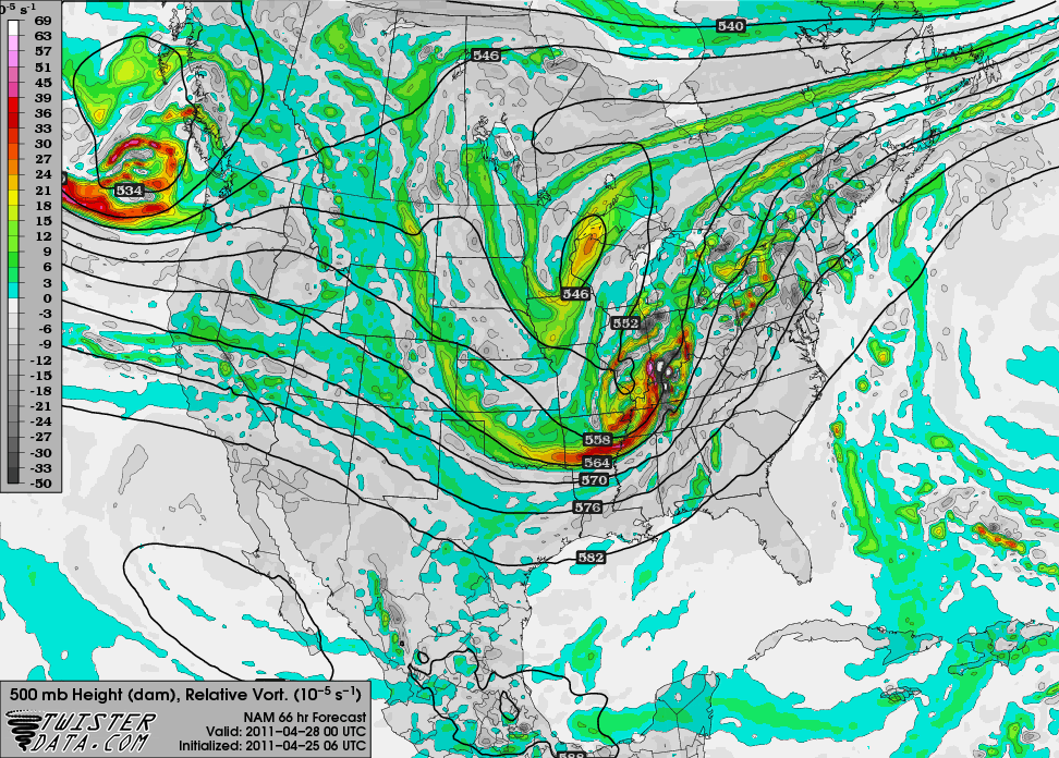
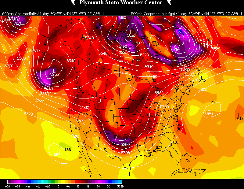
Shows up nice on PV maps.

And the corresponding height field response with greater mid level height falls/cooling than previously projected over much of Ark with initiation in the late afternoon and through the earlier evening.
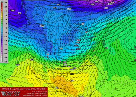
18Z GFS at 60 hours:
12Z GFS yesterday at 12Z:
By Wednesday, it is anyones best guess--but the consequence of that low amplitude leading wave Tuesday and a more zonal and less amplified flow in the overall trough means Wednesday may have a slightly lower ceiling than before although still very impressive. I agree that all three days have nearly equal potential now.
-
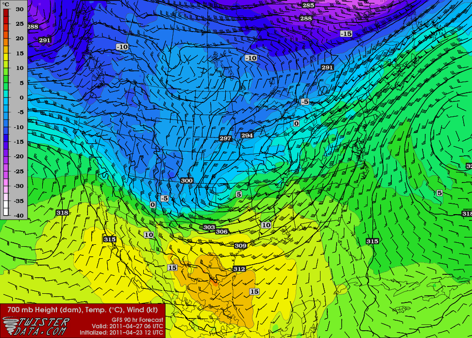
NAM it putting out some sort of freakish 90 KT winds below 800 hpa on Wednesday.
-
Tuesday and Wednesday look to have some amazing potential with all ingredients coming together for what could be a multi-day regional outbreak of severe weather and tornadoes. Obviously some fine details to work out and with this much precipitation occurring along the frontal boundary, it will be difficult to pinpoint some of the mesoscale features until we get into the more near to short term, but as CUmet stated, all kinds of potential here.
I was actually thinking of keeping this thread for Tuesday-Wednesday, and spinning off a new thread for the Monday event since the Tues-Wed event looks like the main show. The discussion in this thread has been mostly about the Tue-Wed threat thus far too. Honestly, we'll probably end up having 3 separate threads for the 3 different days, given the likely magnitude of the event as a whole, so should we just start that up now?
For now I am ok keeping all three in one. Monday-Tue-Wed will likely be three moderates in a row, possibly a high on Wed at some point. All three days have regions with significant potential although Tue/Wed look to be potentially very dangerous.
-
Are there free Euro maps where I can view surface dew-points/temps? I went to Plymouth State Weather Page and went to contoured model maps, but I couldn't get it to view.
Don't believe that is free. Best you can get is 850 temps. I like using Chinooks page (AMWX poster) for the Euro since he did a nice job choosing colors/contours.
-
Not that I need to repeat what some other great severe wx posters have already mentioned here, but the setup as shown by the GFS is as alarming as any I have seen on modeling in a long time. The LLJ is well out in front of the trailing cold front, and the upper level 500 mb jet punches squarely into the warm sector as opposed to staying near / parallel to the incoming cold front. The 250 mb jet structure is also ideal, as some areas are in both the right rear quad of the departing disturbance, and the left front quad of the stronger incoming one. Also, the GFS shows capping weakening by the evening over AR into western TN, which would spell trouble given storm mode could easily be supercellular / tornadic that far ahead of the front. Will be interesting to say the least to monitor future runs and see how this trends.
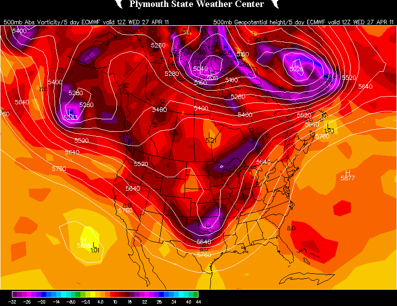
Euro Day 4 has a much more menacing look than the GFS as it ejects a much more E-W consolidated PV anomaly over the warm sector which would incite more vigorous lower tropospheric cyclogenesis than the GFS.
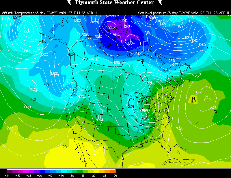
The Euro is showing the potential for positive feedback as well as by day 5 the low is bent back much farther W than the GFS. Still too far out for details--but potential threats can be considered. It is worth mentioning the globals will also not be very indicative yet of feedback potential over a deep low troposphere exhibiting very low static stability/static instability. NAM/SREF/RGEM will catch that potential much better--similar to the 14th through the 17th outbreak (but mainly to the 14th when that intense anomaly ejected over the plains and the rapid tropospheric deep intensification that followed).
Day5 850/SLP.
-
09z SREF already popping a 50 area in nrn MS at 00z Wed, 87h out...

Yeah that is amazing for SREF at 87 hours.
-
-
The medium range guidance as of the last 2 days or so has been more suggestive of the potential for the leading day 4 wave to kick out and eject faster. The result is more amplification/deepening potential of the secondary wave day 5+. Euro suggested that yesterday and now the GFS is suggesting that potential.
-
yes i know.....i am a meteorology major. i do know these things. but i still disagree with their thinking. we all have opinions
Congrats. We have a lot of met majors here. Opinions are great--but do remember SPC is not putting out outlooks and forecasts to appease their own storm chasing fantasies. Just remember that there are folks at SPC who are pioneers in the field of severe weather and severe weather forecasting.
"makes no sense at all what they are doing"
No--quoting Henry Margusity does not count towards providing your opinions.
-
I gave my reasoning in my previous comment. the low pressure is set to track up this way. currently looks like it will through eastern iowa and into the great lakes. that will drag the warm front with it northward. yes the best shear, instability, and moisture will prolly line up south, there will most likely be some instability in this area and plenty of upper air dynamics. yes i know it is probabilistic. their outlooks just make it look like the severe weather will only track in the far southern US and i disagree with this
Yes you told us what the operational models were already saying. There is far more to forecasting than that. Do remember we are talking Day 4-5+ here.
-
i think those outlooks are way too small and way too south. that really needs to extend way north also with advancing warm sector. the low pressure is heading into the great lakes. makes no sense at all what they are doing
If you disagree--please provide your own reasoning/discussion for such disagreement. Do remember these are probabilistic outlooks which take into consideration many other factors besides the operational models alone.
Historic Tornado Outbreak April 27, 2011
in Weather Forecasting and Discussion
Posted