
baroclinic_instability
-
Posts
7,869 -
Joined
-
Last visited
Content Type
Profiles
Blogs
Forums
American Weather
Media Demo
Store
Gallery
Posts posted by baroclinic_instability
-
-
I'm actually thinking seriously about switching majors to electrical or mechanical engineering. I have only completed 2 yrs of college so far, and the great thing is I did not waste time really because all the math/physics/gen ed classes required for MET is required for Engineering, and I have not taken any MET classes. So as much as it pains me to possible do this, math is also a big passion of mine, and engineering was always my plan B. Thoughts?
Note my sig. I was already set to be a MET major, but now is the time to switch as that is not set in stone yet.
There are a lot of options out there. I have a number of friends who graduated with a met degree then went into various engineering programs for their M.S. degrees--and they are successful and working in the engineering field. Doing this route would give you a chance to pursue your passion (meteorology) while setting you up for a different field should it not work out. Of course--this would also require that you get a M.S. Double majoring is possible, but that would be tough doing met/engineering at the same time. That is another possibility though.
-
If I cared all that much about money, I wouldn't have gone into meteorology in the first place, I'm much more motivated by advancing the science or improving the lives of the population as a whole.
Exactly. I love helping people and having a positive impact in peoples lives--even if they don't know it. Weather is an important job--and that is all anyone could ask for in a career field.
-
My arguments weren't just about money though. Facts are fact and the issue is that there are only a couple hundred entry level jobs opening a year with the number of grads per year in the 600-1000 range ( see http://journals.amet.../2008BAMS2375.1 ) How does that make it a good time to be a met? I know my new posts are going to anger a bunch of people since they can't stand it if I have the last word on this issue. But sorry, I strongly believe I'm right - the facts unfortunately support my arguments. We'll have to agree to disagree.
Sometimes you make silly points over and over again for no reason (hence why some folks get fed up with your posts)--but I agree with you here. It is such a tough market for all levels of meteorologists from B.S. to Ph.D. I think others have alluded to it here--but the best thing one can do is gain as much unique experience as possible in college to standout from the rest, try and get internships during the summer, volunteer at a NWS office, and double major in a different field for backup.
-
One positive aspect was that this was pretty obvious from over a week out, from the perspective of great potential being there, no doubt.
True. There was always the feeling of something extreme, but some (including me) felt some of the other days (by day 3 before the outbreak) may exceed yesterday. Others felt the previous convection would (and resultant cold pool) disrupt yesterdays potential. Others, including me, felt the lack of significant "bombing" would cut down on the hodograph turning, etc. I knew a high risk yesterday was likely by a day and a half ago--but not to the extreme it eventually developed into.
-
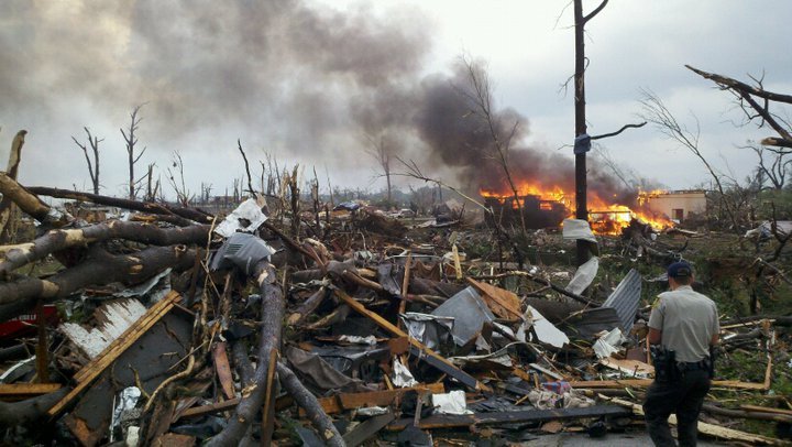
Accidental death by any kind, especially because of the weather probably one of the most tragic things that can happen to families; just an unfair reality, and It devastating that many metro areas/towns were affected. Many thoughts and prayers go out there. These last couple weeks first with Raleigh, then St. Louis, then Tuscaloosa/Birmingham is eye-opening to the fact that no area is less susceptible to tornado damage, no matter how populated or localized. Great job everyone posting updates/radar/velocities/videos; this forum definitely provides outstanding analysis and warning.
I give special kudos to Fred Gossage, TornadoTony, and CUmet who never really wavered from what they believed was a historic event.
-
178 is the latest toll.
Just horrific. I hate tossing numbers around when it is human lives we are talking. Tragic--and it makes me want to work all that much harder to be the best met I can. Horrible news.
-
Birmingham, AL's disco this morning. I could not imagine having to write it.
WOW...WHAT A DAY. MANY THOUGHTS AND PRAYERS GO OUT TO THOSE IMPACTED BY WEDNESDAYS HISTORIC TORNADIC OUTBREAK ACROSS THE STATE. TRYING TO WRITE A DISCUSSION AFTER SUCH AN ACTIVE DAY IS QUITE DIFFICULT. HOWEVER THE WEATHER NEVER ENDS AND WE MUST CONTINUE. THE NEXT FEW DAYS WILL BE CLEAR...SO THE CLEAN-UP PROCESS CAN BEGIN ACROSS THE STATE. WE ARE GOING TO GO FROM WELL ABOVE NORMALTEMPERATURES OVER THE PAST FEW DAYS TO ACTUALLY BELOW NORMALTEMPERATURES FOR TODAY AS THE COLD FRONT CONTINUES TO PUSH EAST OFTHE AREA. THERE WILL BE SOME MODERATION IN TEMPERATURES THROUGHSATURDAY.THE NEXT WEATHER WILL BEGIN TO MOVE IN ON SUNDAY AS THE NEXT COLDFRONT APPROACHES FROM THE NORTH. MODELS ARE VERY FAR APART INREGARDS TO THIS TIME-FRAME SO THERE IS QUITE A BIT OF UNCERTAINTYTO SAY THE LEAST. THE EURO BLAST THE FRONT THROUGH THE AREA BYMONDAY...WHILE THE GFS HOLDS THE FRONT UP AND BRINGS US SEVERALBANDS OF SHOWERS AND THUNDERSTORMS THROUGH TUESDAY. LOOKING BACKAT PREVIOUS DAYS ABOUT THE ONLY CONSISTENCY BETWEEN MODELS IS THEFACT THAT THEY CONTINUE TO DISAGREE. HOPEFULLY WE CAN GET SOMECONSISTENCY IN HERE WITHIN THE NEXT DAY OR SO. ONE THING TONOTE...IF THE GFS PANS OUT WE COULD SEE A ROUND OR TWO OF STRONGTO MAYBE EVEN SEVERE STORMS...BUT THE INCONSISTENCIES IN THEMODELS ARE JUST TOO LARGE TO INCLUDE AT THIS TIME.
-
Not sure if this video was posted or not. Sorry if it was.
Wow--another great closeup vid. This tornado will likely have a lot more vids showing up in the coming days as folks upload and share them.
-
I like this statement:
I think its aimed at the fact we always want more information today. Is it reallllllly headed for me, or is it 5 miles away?
That is great information to have. That type of stuff saves lives--and being prepared like that is something great to see. I loved how they posted continuous updates through the day as things were ongoing.
-
Great to see this. University of Alabama at Tuscaloosa was prepared. Shows how prep can really make a difference. Read from the bottom up. http://www.ua.edu/weather/
-
I'd say this looks like a EF5. I've seen tornado damage from an EF4 twice and I don't believe it was quite as severe as what this was. Still there basically is little difference between the two
Yeah I agree--the devastation is just absurd.
-
Agreed. I'm no expert, either-- I'm a severe part-timer, at best-- but a casual glance suggests EF4-- for the reasons you cited.
Cmichweather posted this earlier comparing it to Moore.
Check this image too:
-
Back on the topic (and sorry I dragged it off a little)... What is the estimated EF rating for the Tuscaloosa event? I am sure it's discussed above, and sorry for asking y'all to rehash-- but it's a big thread. Does it look like an EF4?
I am no tornado expert and I have yet to have any experience doing surveys, but the damage has to be representative of at least EF4 based on pics, possibly EF5. We will see.
Totally stripped trees with no branches, destroyed buildings of decent size, rubble everywhere, etc.
-
-
Shows how pathetic news is here in the US. BBC and and other European news sites have their front page news stories about this event. Here--CNN has the Obama birth certificate/Donald Trump crap as the front page news. What a joke.
-
The outbreak is at the top of the news in Europe this morning-- not just in London, but even in Prague. Below is one of the main dailies here. The headline reads, "Storms and tornadoes ravage three states in the USA and kill 72 people".

Wow amazing that made front page news overseas. I am still in awe of this event myself.
-
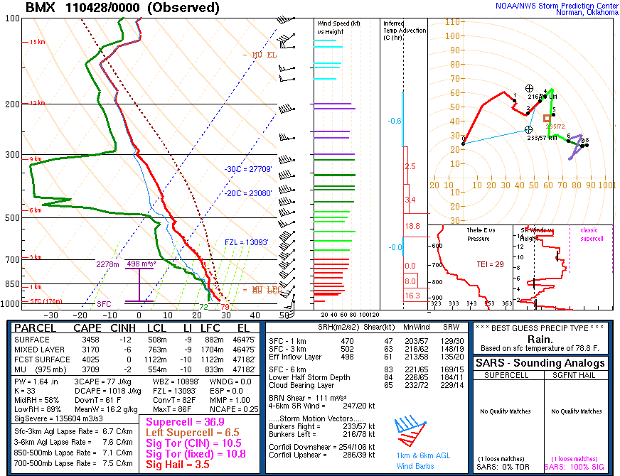
An MCD I will never forget just as this was getting going.
MESOSCALE DISCUSSION 0629 NWS STORM PREDICTION CENTER NORMAN OK 0256 PM CDT WED APR 27 2011 AREAS AFFECTED...MUCH OF MS/AL INTO SOUTHERN TN AND NORTHWEST GA CONCERNING...TORNADO WATCH 232...235... VALID 271956Z - 272200Z THE SEVERE WEATHER THREAT FOR TORNADO WATCH 232...235...CONTINUES. PARTICULARLY DANGEROUS SITUATION /PDS/ TORNADO WATCHES 232/235 CONTINUE UNTIL 00Z/03Z RESPECTIVELY. THIS INCLUDES THE POTENTIAL FOR LONG-TRACK STRONG/PERHAPS VIOLENT TORNADOES INTO THIS EVENING AS A SEVERE WEATHER OUTBREAK ONLY INCREASES IN MAGNITUDE/RISK. AN EXTREMELY DANGEROUS/LIFE-THREATENING SITUATION CONTINUES TO UNFOLD THIS AFTERNOON ACROSS A LARGE PART OF MS/AL...WITH ADJACENT PORTIONS OF TN/NORTHWEST GA ALSO EXPECTED TO BECOME A CONCERN LATE THIS AFTERNOON/EVENING. CURRENT OBSERVATIONAL TRENDS...REASONABLY SUPPORTED BY EXPERIMENTAL HRRR GUIDANCE...IMPLY THAT SCATTERED SUPERCELLS WILL CONTINUE TO FORM IN BROKEN NNE-SSW ORIENTED CORRIDORS OF SUBTLE CONFLUENCE AHEAD /EAST/ OF MORE STORMS/SUPERCELLS THAT ARE DEVELOPING ALONG A PRE-COLD FRONTAL TROUGH/DRYLINE GENERALLY NEARING I-55 IN MS. THE WARM SECTOR AIRMASS HAS AGGRESSIVELY DESTABILIZED THIS AFTERNOON AMID NEAR 70F/LOWER 70S F SURFACE DEWPOINTS...REFERENCE SPECIAL 18Z OBSERVED RAOBS FROM JACKSON MS/BIRMINGHAM AL...WITH A WIDE/HIGHLY SHEARED MOIST SECTOR IN PLACE ALONG/SOUTH OF A MODIFYING WEST-EAST OUTFLOW BOUNDARY /NOW AN EFFECTIVE WARM FRONT/ ACROSS FAR NORTHERN PORTIONS OF AL/MS. EXTREME LOW LEVEL SHEAR...VIA LONG/CURVING LOW LEVEL HODOGRAPHS...WILL REMAIN HIGHLY CONDUCIVE FOR SUPERCELLS CAPABLE OF LONG-TRACK STRONG/VIOLENT TORNADOES INTO THIS EVENING AMID 0-1 KM SRH OF 300-500 M2/S2 OR GREATER /ESPECIALLY NEAR THE AFOREMENTIONED NORTHERN MS AND AL BOUNDARY/. ..GUYER.. 04/27/2011
-
I agree, as much as we all love extreme weather, these days just make us have to stop and think. I mean, extreme to me is an 80mph gust of wind in a squall line. I cant fathom some of the numerous events that have taken place today. Thankfully there was lots of warning, but with the warning, what can you really do to protect yourself when theres an F4 or F5 bearing down on you?
I agree. I love meteorology and I am fascinated by it--but an event like this is so sobering.
really I don't want to be making a snap decision, these were strong tornadoes that hit populated areas, I just wonder if all the lose of life were attributed to ppl being in the safest position and taking the warnings seriously.
Just think how bad it would have been before the advent of warning systems, etc. I agree a large majority of lives lost were likely folks who couldn't do anything about.
-
The images of destruction are mind blowing and sad. http://www.hamwx.com/?page_id=3969
-
Hello, all. New poster. Unbelieveable outbreak today. I'm thinking, in terms of devastation and deaths, it could rival or equal 74. Unbelievable to see all the coverage and videos of the tornado that treked through Tuscaloosa and Birmingham proper as well. Very scary day, and its continuing into the night.
Welcome to the board. It was/is a historic outbreak. I will never forget this one. It reminds me how important the job of a meteorologist truly is. Kudos to the NWS offices, SPC, emergency managers, news outlets, etc for saving countless lives today.
-
You could warn an area until your blue in the face.
If it falls upon deaf ears, then there will be fatalities.
Or if you have tornadoes that rip houses off foundations and destroy large buildings...
-
The Birmingham 0Z sounding is still juiced with some outrageous shear/helicity values.
-
Expanded high risk east to include Atlanta.
-
Anymore silly posts from anyone (yes you mongoose) and you will be immediately 5 posted.
Reconsider majoring in meteorology!
in Weather Forecasting and Discussion
Posted
An honest--question, what are the chances V2 would have secured its funding (or the amount of funding it eventually achieved) if it did not include "increased warning times" and "lived saved" in proposals?