
baroclinic_instability
-
Posts
7,869 -
Joined
-
Last visited
Content Type
Profiles
Blogs
Forums
American Weather
Media Demo
Store
Gallery
Posts posted by baroclinic_instability
-
-
Those high wind launches are always your best stories, and the ones you'll remember. Though I can honestly say I never had the pleasure of even approaching 65 mph.
Oh I already have all sorts of stories. Best launch yet was a balloon that got caught in the downstream eddy of the UA building and essentially knocked straight into the ground 2-3 times (including one full revolution). The sonde was slammed into the ground, but the flight was still successful.
-
A couple pics from Denali yesterday.
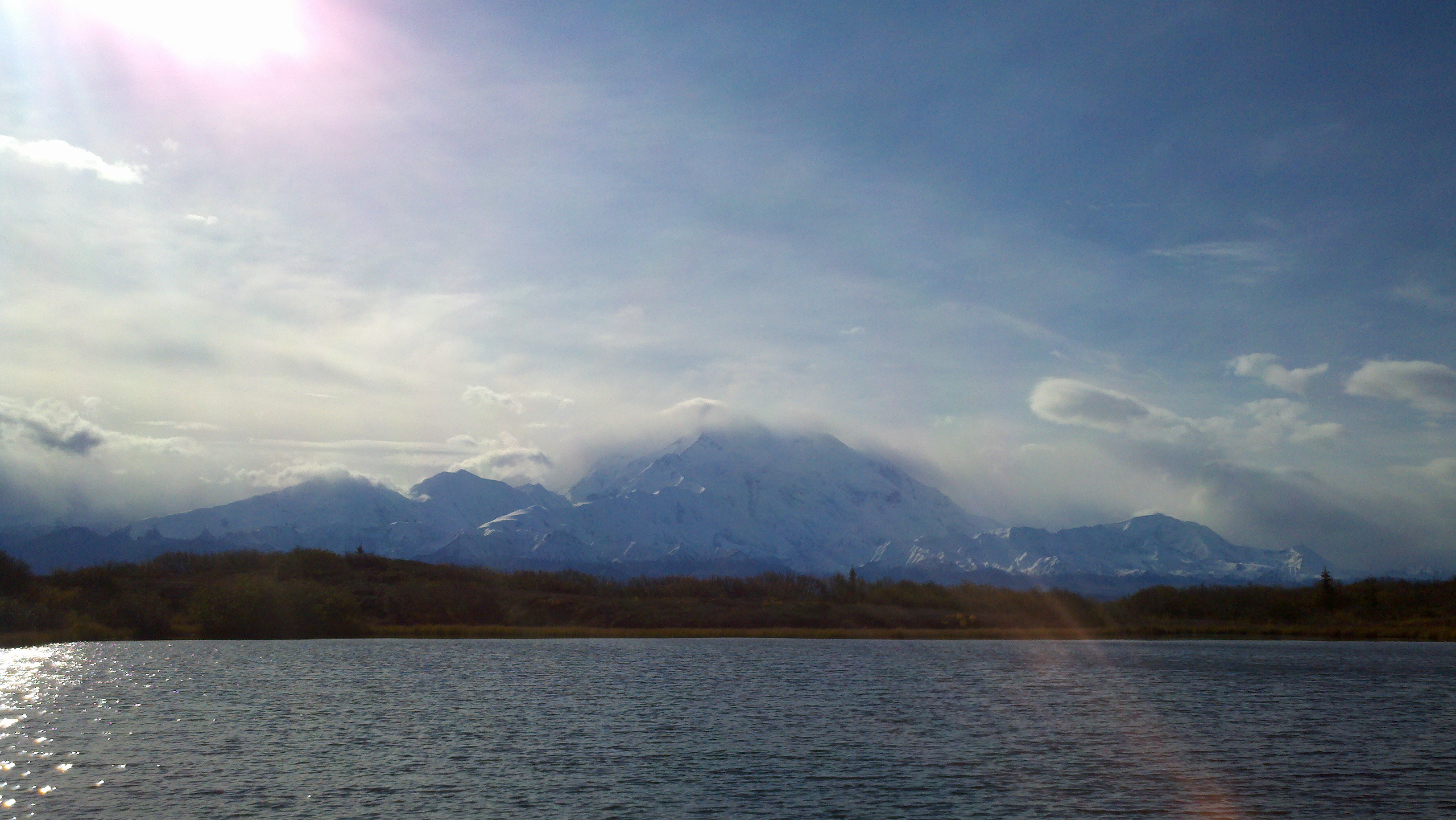
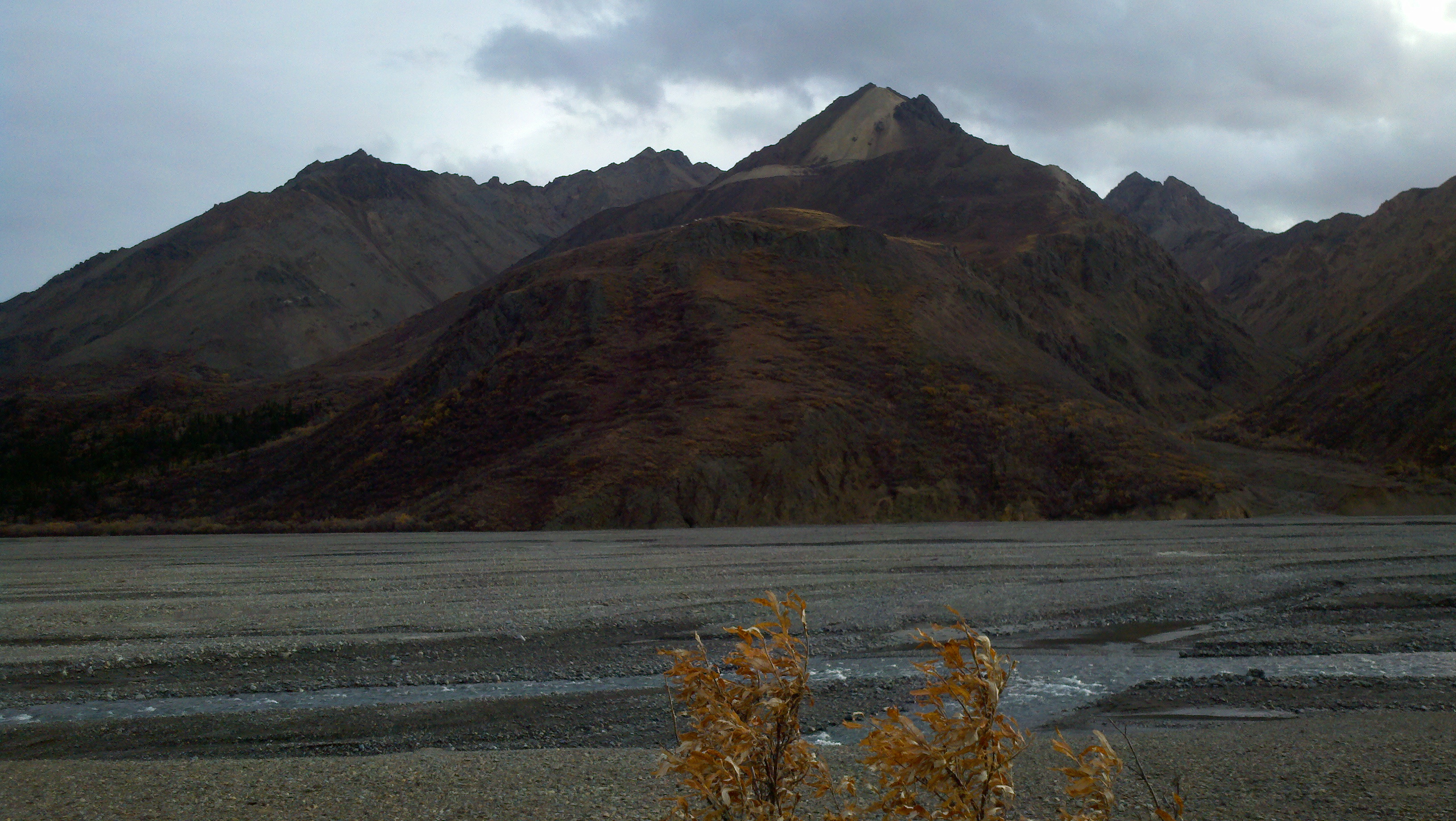
Snow levels look insanely low on Denali (Mckinley).
What is the height of the bottom mountain? 4-5000 feet?
-
I wonder if it'll be a windy week....hmmmm....
AKZ181-201300-
ALASKA PENINSULA-
INCLUDING...COLD BAY...SAND POINT
400 PM AKDT MON SEP 19 2011
...STRONG WIND THROUGH LATE WEDNESDAY NIGHT THROUGH CHANNELED
TERRAIN...
.TONIGHT...NUMEROUS SHOWERS. LOWS IN THE LOWER 40S. NORTHWEST
WIND 25 TO 40 MPH WITH GUSTS TO 55 MPH THROUGH CHANNELED TERRAIN.
.TUESDAY...NUMEROUS SHOWERS. HIGHS IN THE UPPER 40S. WEST WIND 25 TO
40 MPH WITH GUSTS TO 55 MPH THROUGH CHANNELED TERRAIN.
.TUESDAY NIGHT...SHOWERS. LOWS IN THE MID 40S. WEST WIND 30 TO
40 MPH WITH GUSTS TO 55 MPH THROUGH CHANNELED TERRAIN.
.WEDNESDAY...SHOWERS. HIGHS IN THE UPPER 40S. WEST WIND 20 TO
35 MPH WITH GUSTS TO 50 MPH THROUGH CHANNELED TERRAIN.
.WEDNESDAY NIGHT...SHOWERS. LOWS IN THE MID 40S. WEST WIND 25 TO
35 MPH WITH GUSTS TO 50 MPH THROUGH CHANNELED TERRAIN.
.THURSDAY...CLOUDY WITH A CHANCE OF SHOWERS. HIGHS AROUND 50.
.THURSDAY NIGHT THROUGH MONDAY...MOSTLY CLOUDY WITH A CHANCE OF
RAIN. LOWS 40 TO 45. HIGHS AROUND 50.
LOL, have fun with those upper air launches. I hate launching above 30, forget 50+.
-
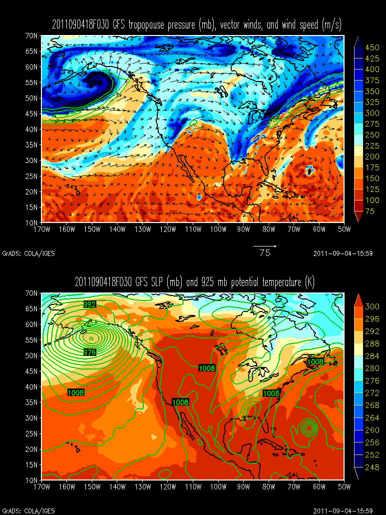
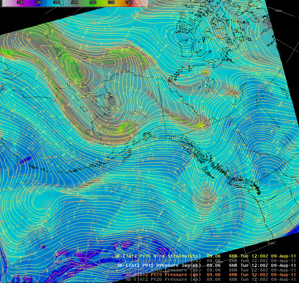
The 00z NAM run from last evening showed the dynamic tropopause (1.5 potential vorticity surface) on the "cinnabun low" all the way down to 936 millibars. One heckuva stratospheric intrusion. The upper low is what is left of last weeks high amplitude trough after being pinched off by ridging to the northeast and the incoming WAA across the Aleutians.
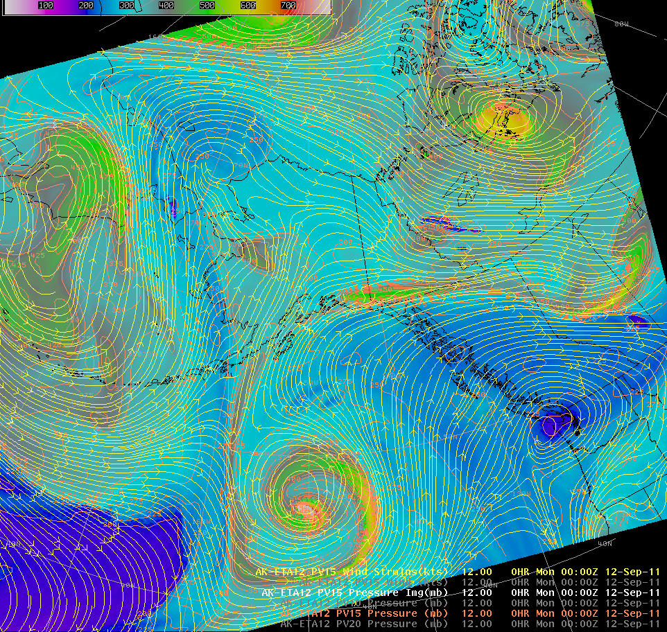
I couldn't get a X-section from the ETA but the GFS shows the gist of it quite well....
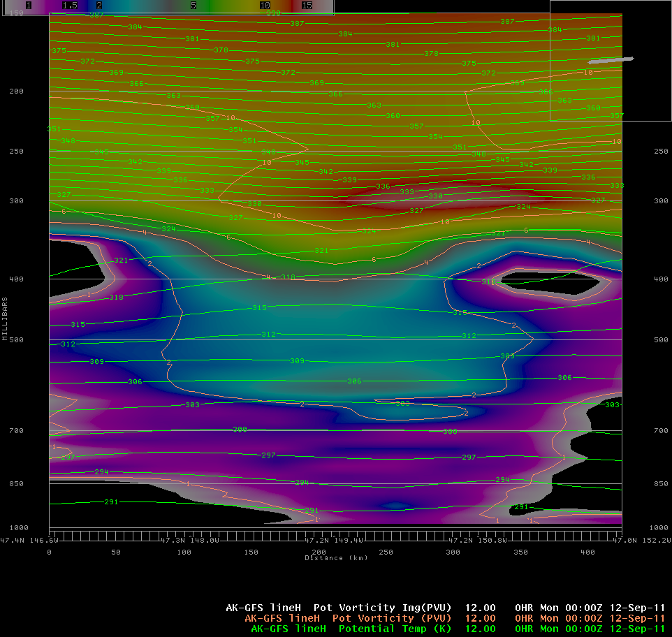
That is awesome, it is nice seeing the PVU surface. It was a pretty classic marine occlusion/dry swirl in that the vertical isentropic mass ascent was directly into the center of the low in response to the upper PV and the mass wind fields it supported (the divergent jet max). Pretty awesome.
-
Some pics from Cold Bay....

That second pic is stunning, is that the top elevation on Cold Bay?
-
Good morning,
Today, low of -3.1C, down to -6 in Burwash.
Yesterday we did a 15 kms hike in the area to have a look at the magic fall colours.
Here are some of the pictures I took:


The other pictures can be found here: http://meteowhitehor...bumFall2011.php.
For today, the weather should be sunny with highs of 13/15C.
Have a good day
 !
!MtBlanc, I am glad to have you here on the forums. The first picture is absolutely stunning and gorgeous.
-
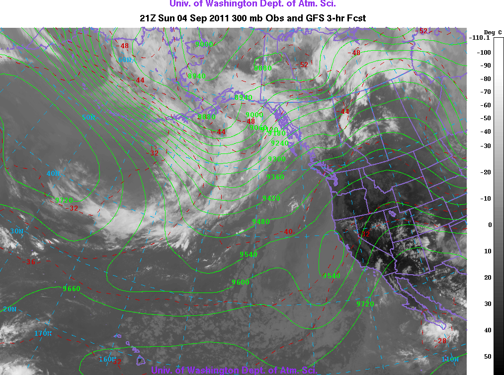
Nice classic marine occlusion and dry swirl in the GOA.
-
Pretty boring disco today....
FXAK68 PAFC 101252 AFDAFC SOUTHCENTRAL AND SOUTHWEST ALASKA FORECAST DISCUSSION NATIONAL WEATHER SERVICE ANCHORAGE AK 500 AM AKDT SAT SEP 10 2011 .ANALYSIS AND UPPER LEVELS... COMPLEX SPLIT UPPER FLOW PATTERN EXISTS TODAY WITH EMBEDDED DISTURBANCES IN THE WESTERLIES OVER THE NORTHERN TWO-THIRDS OF THE STATE. LINGERING HIGH AMPLITUDE TROUGH THAT BROUGHT CLIMATOLOGICALLY COOL AND WET WEATHER TO MUCH OF SOUTHERN ALASKA CONTINUES TO GET PINCHED OFF AS RIDGING BUILDS ACROSS THE ALEUTIANS AHEAD OF THE NEXT DISTURBANCE. AN EMBEDDED SHORT-WAVE TROUGH BRINGS THE THREAT OF RAIN TO THE KUSKOKWIM DELTA REGION THIS MORNING. AT THE SURFACE...RIDGING BUILDING WESTWARD ACROSS THE NORTHERN GULF OF ALASKA. .MODEL DISCUSSION... MODEL GUIDANCE IS IN GOOD AGREEMENT SYNOPTICALLY FOR THE SHORT TERM AS AN UPPER LEVEL LOW DEVELOPS FROM KAMCHATKA PENINSULA AND EAST THIS WEEKEND. MODELS ALL SIMILAR WITH A MID-970MB LOW IN THE NORTHWEST BERING SEA. A WEAKENING SURFACE LOW WILL MOVE INTO THE GULF OF ALASKA BY EARLY MONDAY MORNING IN THE LOW 990MB RANGE. AS THE UPPER LEVEL JET PUSHES SOUTH OF THE ALEUTIANS AN ELONGATED TROUGH WILL STRETCH FROM EAST ASIA THROUGH THE CENTRAL ALEUTIANS WITH AN EXTENSION INTO THE GULF OF ALASKA. .SHORT TERM FORECAST... SOUTHCENTRAL ALASKA...CONSIDERABLY DRIER WEATHER FOR MUCH OF THE AREA WITH RELATIVELY WEAK FLOW ALOFT. PARTLY CLOUDY TO PARTLY CLEAR CONDITIONS WILL EXIST. DRY CONDITIONS LOOK TO CONTINUE THROUGH THE WEEKEND UNTIL AN UPPER LEVEL DISTURBANCE PUSHES INTO THE GULF BRINGING RAIN TO MAINLY COASTAL AREAS EARLY NEXT WEEK. SOUTHWEST ALASKA...A WEAKENING SHORT-WAVE TROUGH MOVING ONSHORE IN THE YUKON DELTA REGION BRINGS AREAS OF RAIN TO THE KUSKOKWIM DELTA IN THE MORNING AND MOVING INTO THE KUSKOKWIM VALLEY/MTS FOR THE AFTERNOON. GENERALLY CLOUDY CONDITIONS WILL CONTINUE FOR MUCH OF THE SOUTHWEST INTERIOR AND BRISTOL BAY REGIONS. BERING SEA AND ALEUTIANS...UPPER LEVEL DISTURBANCE AND ASSOCIATED FRONT PUSH ACROSS THE CHAIN FROM WEST TO EAST BRINGING PERIODS OF RAIN AND GUSTY SOUTHERLY WINDS THIS WEEKEND. .LONG TERM FORECAST... FOR THE EXTENDED PERIOD A BROAD UPPER LEVEL LOW WILL BE ANCHORED OVER THE BERING SEA BRINGING GENERALLY CLOUDY CONDITIONS WITH RAIN SHOWERS. AS DISTURBANCES ROTATE AROUND THE FRINGE OF THIS TROUGH PERIODS OF UNSETTLED WEATHER CAN BE EXPECTED FOR COASTAL REGIONS OF THE SOUTH CENTRAL AND THE GULF OF ALASKA. .AER/ALU...WATCH/WARNING SUMMARY PUBLIC...NONE MARINE...132 150 170 172 179 180 185 FIRE WEATHER...NONE MTL SEP 11
If you use COD text it will remain formatted.
240
FXAK68 PAFC 101252
AFDAFC
SOUTHCENTRAL AND SOUTHWEST ALASKA FORECAST DISCUSSION
NATIONAL WEATHER SERVICE ANCHORAGE AK
500 AM AKDT SAT SEP 10 2011
ANALYSIS AND UPPER LEVELS
COMPLEX SPLIT UPPER FLOW PATTERN EXISTS TODAY WITH EMBEDDED
DISTURBANCES IN THE WESTERLIES OVER THE NORTHERN TWO-THIRDS OF THE
STATE. LINGERING HIGH AMPLITUDE TROUGH THAT BROUGHT CLIMATOLOGICALLY
COOL AND WET WEATHER TO MUCH OF SOUTHERN ALASKA CONTINUES TO GET
PINCHED OFF AS RIDGING BUILDS ACROSS THE ALEUTIANS AHEAD OF THE NEXT
DISTURBANCE. AN EMBEDDED SHORT-WAVE TROUGH BRINGS THE THREAT OF RAIN
TO THE KUSKOKWIM DELTA REGION THIS MORNING. AT THE SURFACE...RIDGING
BUILDING WESTWARD ACROSS THE NORTHERN GULF OF ALASKA.
MODEL DISCUSSION
MODEL GUIDANCE IS IN GOOD AGREEMENT SYNOPTICALLY FOR THE SHORT TERM
AS AN UPPER LEVEL LOW DEVELOPS FROM KAMCHATKA PENINSULA AND EAST THIS
WEEKEND. MODELS ALL SIMILAR WITH A MID-970MB LOW IN THE NORTHWEST
BERING SEA. A WEAKENING SURFACE LOW WILL MOVE INTO THE GULF OF ALASKA
BY EARLY MONDAY MORNING IN THE LOW 990MB RANGE. AS THE UPPER LEVEL
JET PUSHES SOUTH OF THE ALEUTIANS AN ELONGATED TROUGH WILL STRETCH
FROM EAST ASIA THROUGH THE CENTRAL ALEUTIANS WITH AN EXTENSION INTO
THE GULF OF ALASKA.
SHORT TERM FORECAST
SOUTHCENTRAL ALASKA...CONSIDERABLY DRIER WEATHER FOR MUCH OF THE AREA
WITH RELATIVELY WEAK FLOW ALOFT. PARTLY CLOUDY TO PARTLY CLEAR
CONDITIONS WILL EXIST. DRY CONDITIONS LOOK TO CONTINUE THROUGH THE
WEEKEND UNTIL AN UPPER LEVEL DISTURBANCE PUSHES INTO THE GULF
BRINGING RAIN TO MAINLY COASTAL AREAS EARLY NEXT WEEK.
SOUTHWEST ALASKA...A WEAKENING SHORT-WAVE TROUGH MOVING ONSHORE IN
THE YUKON DELTA REGION BRINGS AREAS OF RAIN TO THE KUSKOKWIM DELTA IN
THE MORNING AND MOVING INTO THE KUSKOKWIM VALLEY/MTS FOR THE
AFTERNOON. GENERALLY CLOUDY CONDITIONS WILL CONTINUE FOR MUCH OF THE
SOUTHWEST INTERIOR AND BRISTOL BAY REGIONS.
BERING SEA AND ALEUTIANS...UPPER LEVEL DISTURBANCE AND ASSOCIATED
FRONT PUSH ACROSS THE CHAIN FROM WEST TO EAST BRINGING PERIODS OF
RAIN AND GUSTY SOUTHERLY WINDS THIS WEEKEND.
LONG TERM FORECAST
FOR THE EXTENDED PERIOD A BROAD UPPER LEVEL LOW WILL BE ANCHORED OVER
THE BERING SEA BRINGING GENERALLY CLOUDY CONDITIONS WITH RAIN
SHOWERS. AS DISTURBANCES ROTATE AROUND THE FRINGE OF THIS TROUGH
PERIODS OF UNSETTLED WEATHER CAN BE EXPECTED FOR COASTAL REGIONS OF
THE SOUTH CENTRAL AND THE GULF OF ALASKA.
AER/ALU
WATCH/WARNING SUMMARY
PUBLIC...NONE
MARINE...132 150 170 172 179 180 185
FIRE WEATHER...NONE
MTL SEP 11
-
Just a question, what does +SN mean? Sorry, I come from France
 !
!We had a great day today with sun and warmer temperatures 6.9/17.1C. It was however quite windy.
Tomorrow, it will be sunny, but a little bit cooler.
Have a great one !
Ha, +SN = heavy snow. It is the surface observation term used by the surface observing system here. Light, moderate, and heavy are the discriminators used for precipitation rates. So, for instance, light snow would be -SN, moderate snow would simply be SN, and heavy snow would be +SN. Good question though. Thanks for all the nice pictures up there...should be a fun winter up there. Just curious, how did you end up there from France?
-
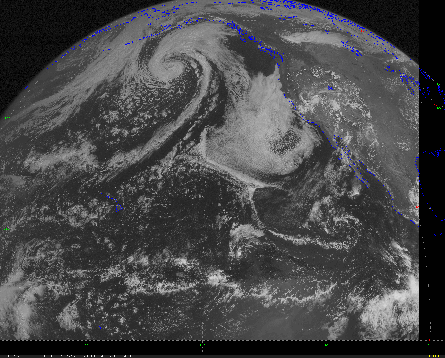
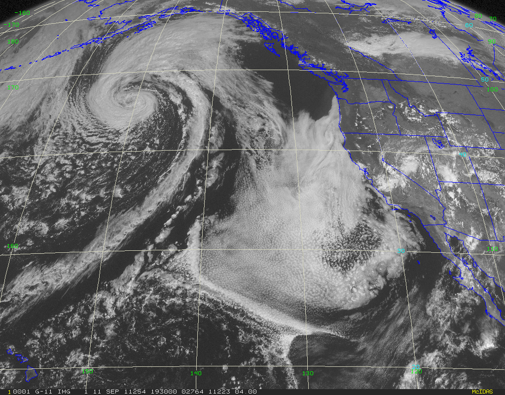
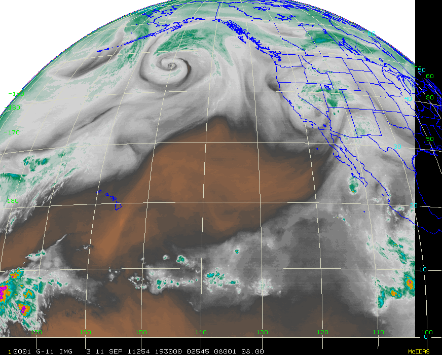
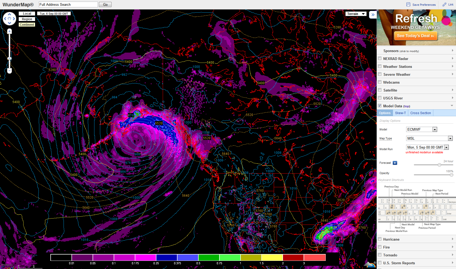
The GOA cyclone is massive, almost the size of the lower 48. Nothing terribly out of the ordinary for the GOA, but nice to see again. Bring on the baroclinic pain.
-
How did the 0Z Cold Bay sounding look tonite?
-
Polar Jet is about to drob the bomb in the Gulf of Alaska with a sub 960 bomb. GFS?EC bomb it out 25-30+ hpa in 24 hours.
-
pictures from Yukon?
Yes, from your location. It is a pretty sparsely populated area...not a lot of people have been there before. It would be neat to see images. I know a bit about the terrain/geography, but it would be neat to see images of the locale.
-
Thank you
 !
!For the amateurs of up 60N, we will soon open a page to track weather conditions in arctic and subartctic areas.
I will let you posted.
I already have some infos here for those who are passionate with cold.
You should post some pictures of the area from up that way.
-
At Whitehorse Airport it can snow every month apart July.
The most important snowfall in August was 8.6 cm on Aug. 22, 1974.
Usually snowpack starts to form mid October, last year it was mid November.
We however got 12 cm snowfall on Sept. 24 last year.
You can find all the reports for my new weather station here (reports) and here (WU).
About today, low of -1.8C and high of 16.1C. Sunny day, I would definitely sign for an autumn like this.
Have a great evening !
Welcome to the boards, I am glad to have a weather enthusiast from outside of the lower 48.
-
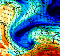
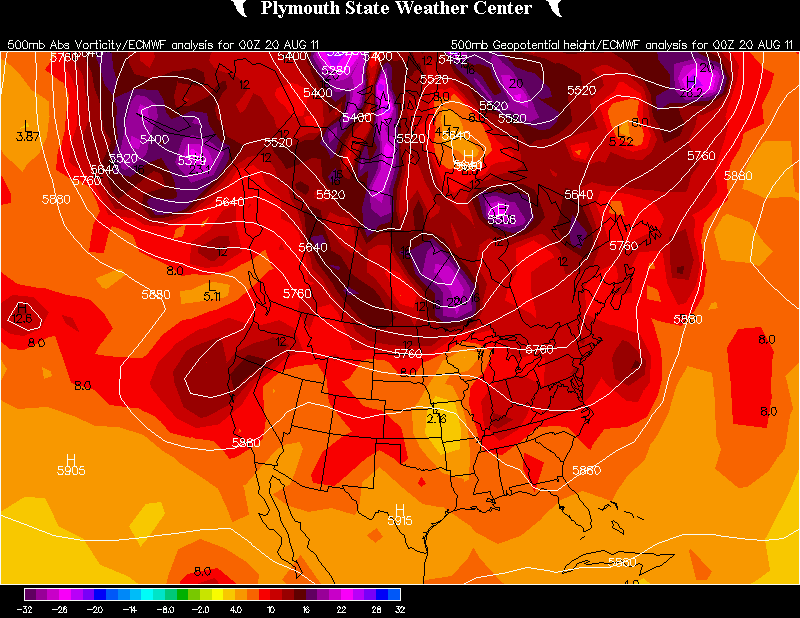
Saw this on a co-workers facebook, but it looks as if Alaska is the only place in the northern hemisphere experiencing any baroclinic pain.
My link IR satellite
Gorgeous. Baroclinic bombs. I will disagree though, there is a fair bit of minor baroclinic pain going in Canada. Hudson Bay doom.
-
Rather than make a long post here, I blogged about some local terrain effects. I struggled with going between technical/non-technical for non-met types so it's kind of in a grey area in between.
Nice post. Interesting features that stick out in the PABE sounding is the strong above mountain top inversion (around 850 hpa) which probably enhanced the trapped wave mode, but probably too high to incite strong downslope winds given the height of the range. I am assuming no major downslope winds?
The other interesting feature is the model cross section which seems to be simulating a vertically propagating mode given the back tilt of the wave w/height. Do you guys have any higher res x-sections? I found the x-section tropopause uniquely flat...also neat to see how the model simulates (actually probably parameterizes) the dampening of the wave as it reaches the tropopause.
-
A moist southwest flow and compact potential vorticity anomaly is continuing a climatologically wet pattern to south central Alaska today. The dynamic tropopause (1.5 PVU surface) extends down to almost 550 mb with the stratospheric intrusion bringing some very dry air close to -80 C dew point. Doesn't look like much at first glance.
Doing some QC on the incoming data I figured I had a faulty hygristor when I first saw the dew point tank. After looking at the upstream sounding from Bethel (PABE) from 00z and the recent 12Z it appears as if it is good data.
Aug 9th 12Z for Anchorage (PAFC) and Bethel (PABE)
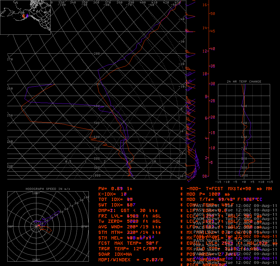
Nice maps. Got to love our awesome hygristors. Nice catch though, looks legit, and it makes sense with that type of deep tropopause that stratospheric mixing is occurring.
-
Those are bada** mtn waves.
-
I see the GFS is progging the return of the 0 degree isotherm to southern Alaska. Nobody wants to see termination dust around here yet!
Termination dust?
I see some DCVA by CD3 progged by the EC/GFS for day 3.5+. Looks pinwheelish.
-
I am interested. I have been keeping up to date on weather up there lately, perhaps because of you and niumetgf, but also because of the extreme boredom of 600 dm subtropical death ridges.
-
It's almost too bad WeatherData is part of Accu... since it seems people will make judgments before even knowing what they are doing there.
Weatherdata is there to make money with respect to a very defined user base with different expectations and impacts. What is too bad is the poor comparison they use in their quote.
-
Glad you are back and ok Jomo

-
That's higher than I expected (I wonder if a decent percentage of those are just tornadoes that were never reported 'cause they happened in sparsely populated areas?)... but not so high that you should say "oh it's just another tornado warning". Even one in four is pretty scary odds for a tornado.
Obviously you all know this, but it's a matter of getting this notion to the general public. Just because you've been tornado warned before and didn't personally see anything doesn't mean you shouldn't take the next one seriously.
It is an incredibly fine line when it comes to tornadoes. Of course crying wolf all the time is not ok since it will inevitably result in the public simply ignoring the warning--but nobody wants to be the one who has no warning on a tornado that potentially kills people. That information needs to get out--and it is likely better that the FAR be a tad high since tor warnings are such a rare event overall.
Alaska/Western Canada obs and discussion
in Central/Western States
Posted
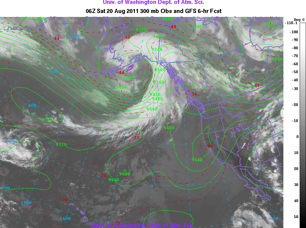
Very impressive bomb about to go off in the GOA near the BC coast. Incredible jet streak, but the very impressive part is both the rapid intensification and extreme low level baro zone. Even more impressive is the rather unimpressive PV. This is being driven nearly solely by a highly divergent jet maxima aloft.
Straight unidirectional 90 knot low level winds and progged nearly dry adiabatic lapse rates. Going to be some possible 100 MPH wind gusts.