Jump to content

Cold Rain

Members
  • Posts

    23,935
  • Joined

  • Last visited

Everything posted by Cold Rain
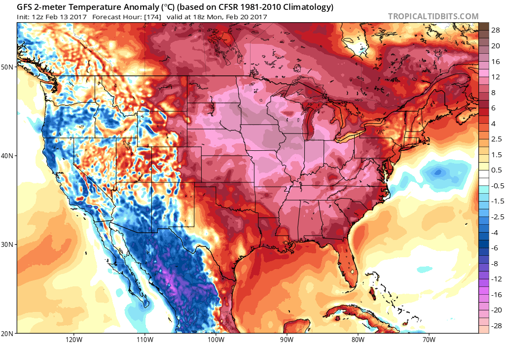
  1. That's well within the margin of error, IMO.
  2. So the crappy models are north and the good models moved south. Cool.
  3. You know it. Going to hit up the French one soon. But seriously, it's interesting to see how things trend, even with the crappy models.
  4. You talking about the RGEM or last night's CMC? The NAM is now making landfall, as does the RGEM, which tracks west after instead of SW.
  5. And the ICON. In fact, neither the RGEM and ICON have the SW motion.
  6. ICON tracks quite a bit farther north after stalling near ILM. Never makes it into SC. The last two runs have been farther north.
  7. ^^ I'm sure everything about that map will operate in reverse in the winter.
  8. Is a larger eyewall more susceptible to ERCs than a smaller one? Or does that matter at all?
  9. Going to be some high rainfall totals again.
  10. Looks like it's turning wnw at 49 on a heading for Myrtle Beach. Edit: Lol 48. What's an hour among bad models?
  11. Wonder if there are any biases to breaking the ridge down too fast or keeping it in place too long, etc. that would be good to know here?
  12. It looks like the stall is happening offshore on most of those. If this trend continues, it would be terrible for beach erosion/flooding/surge but probably better for inland areas, as there should be some weakening of the storm. Wouldn't it be nice for once to have a storm that maintained motion for the duration?
  13. Agreed. I was just wondering out loud if there is any real tendency for models to over-break down steering in the 3-5 day range. I don’t know if that’s a real thing or not, but I’ve seen it happen more than it seems like it should.
  14. This is just anecdotal, but I have seen a lot more 3-4 day model forecasts for stalls (leading to major flooding and disaster) than I have actually seen stalls happen. Really doesn’t tell us much about this situation...just an observation.
  15. I would place the odds of the path moving a few ticks right slightly higher than to the left, at this point.
  16. Good AFD to save: Area Forecast Discussion Issued by NWS Raleigh/Durham, NC Home | Current Version | Previous Version | Text Only | Print | Product List | Glossary Off Versions: 1 2 3 4 5 6 7 8 9 10 11 12 13 14 15 16 17 18 19 20 21 22 23 24 25 26 27 28 29 30 31 32 33 34 35 36 37 38 3940 41 42 43 44 45 46 47 48 49 50 -- Highlight Changed Discussion -- 000 FXUS62 KRAH 101856 AFDRAH Area Forecast Discussion National Weather Service Raleigh NC 255 PM EDT Mon Sep 10 2018 .SYNOPSIS... A front will waver over the Piedmont of NC through Tue. Meanwhile, Hurricane Florence will track west northwest across the southwestern Atlantic Ocean between the Bahamas and Bermuda through Wed, then approach the Southeast U.S. Thursday and Thursday night. && .NEAR TERM /THROUGH TONIGHT/... As of 1105 AM Monday... Main adjustment to the near term forecast was to add the mention of locally heavy/excessive rainfall for location primarily west of highway 1. 12Z upper air analysis and meso analysis depict an abundantly moist atmosphere over central NC with precipitable water values 1.8-2.0 inches. The flow from just above the sfc through 300MB fairly unidirectional from the SW. A mid level trough/shear axis was noted extending from the southern Appalachians to a vort max exiting the eastern Great Lakes. This feature projected to edge slowly east and weaken with time. Meanwhile, a sfc boundary was analyzed west-to-east in vicinity of the the SC border. This feature projected to lift slowly nwd later this afternoon. Convergence along this weak sfc feature coupled with the proximity of the mid level shear axis will initiate/sustain scattered convection this afternoon through this evening. Expect the greatest coverage generally west of highway 1. Due to the deep SW flow, training of showers/storms appears likely. This could lead to localized flooding, especially in low lying areas as well as urbanized locations. Due to the presence of the low level boundary, and the mid level support, scattered convection may persist through midnight, with convection gradually diminishing into the overnight. Extensive low clouds across the Piedmont impeding temperature recovery at this time. If low clouds persist through 17Z, will likely need to adjust max temps down a category, especially along and west of I-85. Expect a repeat performance of the low clouds and patchy fog overnight, mainly across the Piedmont and the northern Coastal Plain. Min temps in the upper 60s-lower 70s. && SHORT TERM /TUESDAY/... As of 415 AM Monday... An upr level low/shear axis will weaken over cntl NC on Tue. Meanwhile in the lwr levels, a surface front will linger and retreat nwwd across the nwrn NC Piedmont and Foothills, and the sea breeze will drift inland. These features will again focus mainly scattered showers and storms, maximized with diurnal heating, Tue afternoon. Low clouds and areas of fog over the nrn and wrn NC Piedmont are likely to disperse more rapidly than previous days, with resultant temperatures more uniformly in the mid-upr 80s throughout cntl NC. && .LONG TERM /WEDNESDAY NIGHT THROUGH MONDAY/... As of 255 PM Monday... WEDNESDAY NIGHT THROUGH FRIDAY NIGHT: As of Monday afternoon, Hurricane Florence has strengthened to a category 4 major hurricane with maximum sustained winds of 130 mph. There remains significant spread in the model solutions, making it difficult and too early to tell where the most significant impacts within the state will occur. With the National Hurricane Center anticipating a Thursday landfall the average track error this far out is between 100-150 nautical miles, and so there are many details yet to be ironed out. There is however increasing confidence that North Carolina will suffer significant impacts from Hurricane Florence and preparations should be completed as soon as possible. For residents of central NC, sustained tropical storm force winds with gusts to hurricane force will be possible. This will likely cause a significant number of power outages and downed trees across the area. The greatest risk to residents of central NC will be with inland flooding. As the storm makes landfall it is expected to slow down, thus increasing the time Florence remains over the state. This will enhance the flooding threat and those who already know they live in a flood prone area need to take appropriate action to make sure they have a safe place to go during the storm. Now is the time to have a plan in place and ready to go and to have your hurricane kits fully stocked. Residents need to be prepared for potentially long periods of time without power or water. Stay tuned to the forecast and to messaging coming from NC Emergency Management for the latest information. You can visit the NWS Raleigh Tropical page at http://www.weather.gov/rah/tropical for information from the National Hurricane Center as well as local statements and forecasts. -Ellis SATURDAY THROUGH MONDAY: This stage of the forecast remains very uncertain, as all of the forecast is reliant on the eventual track, intensity, and survivability of Florence once it makes landfall. In general, models tend to be in agreement with a rapidly decaying yet nearly stationary tropical system overhead by the weekend. This slow progression will likely keep gusty winds and heavy tropical downpours active across much of central NC, with potentially several inches of additional precipitation possible each day. Pinpointing the areas likely to be hardest hit remains very difficult due to the wide array of model spread that still exists, so please continue to monitor for future developments in the forecast. - JJM && .AVIATION /18Z MONDAY THROUGH SATURDAY/... As of 140 PM Monday... Lingering low stratus over portions of the Piedmont, with IFR/low end MVFR ceilings, will lift into a scattered broken cu field by 21z with bases 3500-5000ft. Scattered convection will develop over portions of the Sandhills and southern Piedmont through 21Z. The threat for scattered convection will increase across the remainder of central NC after 21Z, persisting until 02Z. In vicinity of the heavier showers and storms, anticipate IFR visibilities and MVFR ceilings, and wind gusts 25-30kts. After 06Z, areas of low stratus and fog will redevelop across the northern half of central NC, leading to IFR/LIFR ceilings and IFR visibilities. The adverse aviation conditions will likely linger through most of Tuesday morning. Comparable conditions expected Tuesday night into Wednesday. By Thursday, the extremely adverse affects of Hurricane Florence may begin to impact the eastern sections of central NC by Thursday morning, and the entire region by late Thursday, persisting into Friday. Aviation conditions are expected to slowly improve expected by Saturday. && .RAH WATCHES/WARNINGS/ADVISORIES... None. && $$ SYNOPSIS...MWS NEAR TERM...WSS SHORT TERM...MWS LONG TERM...Ellis/JJM AVIATION...WSS
  17. There will be some major damage for interior sections with that run. Yikes.
  18. So that's not a ton different, but you have to say it is caving to the others a little. A couple more cycles like today, and SC should be completely out of the woods.
  19. Not trying to be a weenie, but the GFS track assumes a NW trajectory right now. That isn't occurring so far.
  20. These are good questions. I’m going to punt, as I’ve never had to use one...knock on wood. Can anyone here answer the above, please?
×
×
  • Create New...