

TSSN+
-
Posts
1,566 -
Joined
-
Last visited
Content Type
Profiles
Blogs
Forums
American Weather
Media Demo
Store
Gallery
Posts posted by TSSN+
-
-
1 minute ago, MN Transplant said:
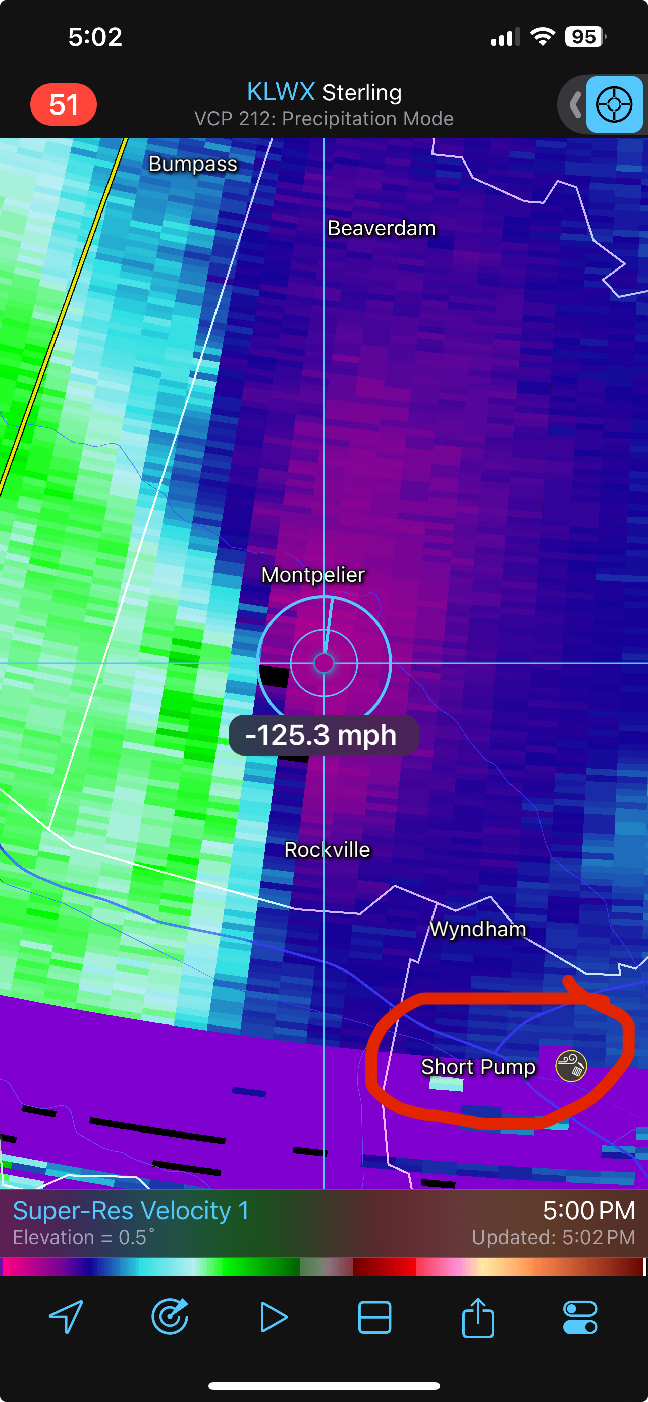
Near our favorite place

How much for Short Pump?
-
 1
1
-
-
If this was summer time woof

-
 2
2
-
-
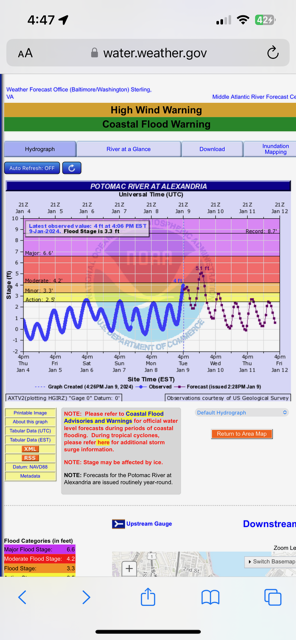
8 minutes ago, stormy said:
I seriously doubt this.
Was just under moderate stage an hour ago so it probably there now.
-
1
-
-
Hold onto your butts here it comes.
-
1
-
-
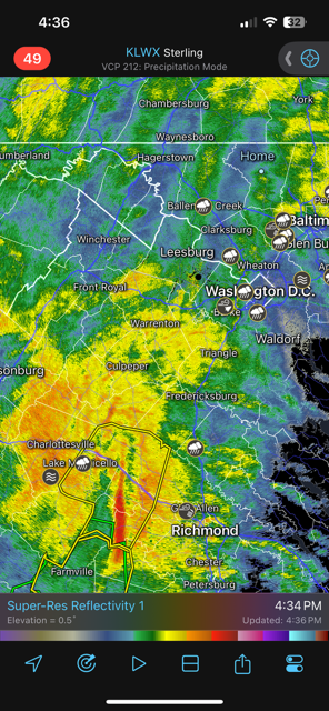
If it looks like this now, later going to be interesting.
-
1
-
-
Just now, WeatherShak said:
Location?
.Profile has it but Westminster
-
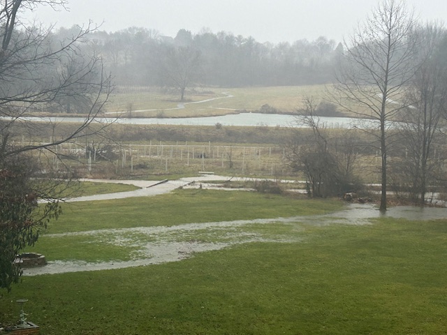
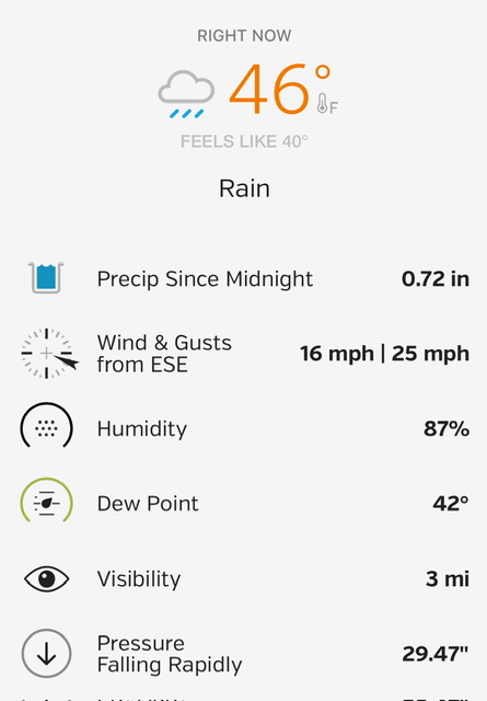
You can really hear the wind just off the surface now. Sounds like a jet engine. Going to come down to surface soon. Street lights are dancing in the wind. The ground is so wet there just water everywhere. The heavy rain later going to push it over the edge.
-
1
-
-
6 minutes ago, Kmlwx said:
I've seen flurries at 50 when the warm layer was very shallow. But I'm in Silver Spring and it's just pouring.
Ya maybe if it was just flurries in some colder air. This is pouring rain with upper levels roasting.
-
1
-
-
Just now, Skidude said:
snow sleet and rain simultaneously high winds temp 47 north bethesda
Snow and sleet at 47 I call bs lol
-
Just popped up to 1.01” on the day. I assume will get over 2”
-
Power just flicked here. I’m sure it’ll go out later if we get what’s expected
-
1
-
 1
1
-
-
Gusitng around 35/40 so far now
-
Tornado watch creeping into southern areas.
-
2
-
-
Up to .72” so far.
-
2 minutes ago, mappy said:
Only going to get worse. I recommended to closing the dance studio tonight so no one had to travel in it, thankfully the owner trusts my weather knowledge enough, and now i don't have to go out later.
Ya looks like after 3pm it really starts to pick up and 5-8pm being the worse.
-
5 minutes ago, mappy said:
.54" so far, winds def have picked up in the last hour.
Ya it’s getting gusty
-
7 minutes ago, AmericanWxFreak said:
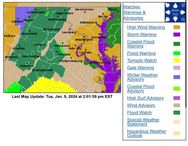
URGENT - WEATHER MESSAGE
National Weather Service Baltimore MD/Washington DC
1225 PM EST Tue Jan 9 2024

DCZ001-MDZ013-016-504-506-VAZ053>055-057-527-100130-
/O.UPG.KLWX.WI.Y.0001.240109T2000Z-240110T0600Z/
/O.EXA.KLWX.HW.W.0001.240109T2000Z-240110T0600Z/
District of Columbia-Prince Georges-Charles-
Central and Southeast Montgomery-Central and Southeast Howard-
Fairfax-Arlington/Falls Church/Alexandria-Stafford-King George-
Central and Southeast Prince William/Manassas/Manassas Park-
Including the cities of Washington, Bowie, Suitland-Silver Hill,
Clinton, College Park, Greenbelt, Laurel, Camp Springs,
St. Charles, Waldorf, Bethesda, Rockville, Gaithersburg,
Silver Spring, Columbia, Ellicott City, Reston, Herndon,
Annandale, Centreville, Chantilly, McLean, Franconia, Arlington,
Alexandria, Falls Church, Falmouth, Dahlgren, Dale City,
Manassas, Woodbridge, Lake Ridge, and Montclair
1225 PM EST Tue Jan 9 2024

...HIGH WIND WARNING IN EFFECT UNTIL 1 AM EST WEDNESDAY...

* WHAT...Southeast winds 25 to 40 mph with gusts up to 60 mph
  expected.

* WHERE...In District of Columbia, District of Columbia. In
  Maryland, Prince Georges, Charles, Central and Southeast
  Montgomery and Central and Southeast Howard Counties. In
  Virginia, Fairfax, Stafford, King George and Central and
  Southeast Prince William/Manassas/Manassas Park Counties, and
  Arlington/Falls Church/Alexandria.

* WHEN...Until 1 AM EST Wednesday.

* IMPACTS...Damaging winds will blow down trees and power lines.
  Widespread power outages are expected. Travel will be
  difficult, especially for high profile vehicles.
Shocked I don’t have a warning in Carroll all the modeling shows the same as dc here maybe worse.
-
Thought this was interesting from
lwx disco
Current soundings continue to
indicate 50-70KT at 925mb, and 70-90KT at 850mb. The evening
sounding tonight at IAD could break observed wind records at
925mb, 850mb, and 700mb.-
1
-
 2
2
-
-
HAZARDOUS WEATHER CONDITIONS FOR BALTIMORE/WASHINGTON
REGION TODAY BETWEEN 500 PM AND 1000 PM EST...Weather conditions will deteriorate as a strong frontal system
approaches this afternoon, then passes through the greater
Baltimore/Washington region this evening. This will result high
winds capable of downing trees and powerlines, tidal flooding, and
the potential for flooding of small streams and creeks. This
will create hazardous travel conditions late this afternoon
through late evening across the region.Light-to-moderate rain will continue early this afternoon, then
increase in intensity late this afternoon, with a several hour
period of heavy, intense rainfall expected between 6 PM and 10 PM.
This heavy rainfall, coupled with already saturated soils from
recent rainfall, will cause flooding of small streams and creeks.
Do not attempt to drive across flooded roadways; additionally,
flooding at night increases the risk for motorists not being able
to quickly identify the water hazards due to decreased
visibilities by the heavy rain and darkness.Easterly winds will increase in intensity as well this afternoon
across the region, with gusts to 50 MPH expected late this
afternoon through mid-evening. Locations closer to the Chesapeake
Bay will see higher wind gusts of 60-70 MPH. Strong winds will
increase the risk of falling trees and downed powerlines. Again,
the risk of poor outcomes resulting from high winds is increased
during nighttime. Winds will decrease after midnight tonight.-
1
-
-
It sucks out. Pouring rain at 38 and windy. Straight raw make you sick weather.
-
6z gfs started the move towards the euro
-
5 minutes ago, JenkinsJinkies said:
Why is it when these things shift warmer 10 days out it never shifts back to snow despite there being plenty of time for models to change?
Once you go bla…. rain, you don’t go back.
-
3
-
-
3 minutes ago, NorthArlington101 said:
it’s setting up a more favorable track for the next storm /s
-
1
-
-
4 minutes ago, Shad said:
looks like a nice setup for the 16th on the euro at hr 216
If you like a cutter sure
-
2
-
Tuesday, January 9 Rain and Wind Storm
in Mid Atlantic
Posted
Power surges here in Westminster. Lights keep dimming. How long till it goes out…