

Snow dog
-
Posts
320 -
Joined
-
Last visited
Content Type
Profiles
Blogs
Forums
American Weather
Media Demo
Store
Gallery
Posts posted by Snow dog
-
-
1 minute ago, btownheel said:
Excited for the Upstate crew. I know you guys have been in the screw zone a ton over the last decade. Look to catch the bullseye here.
Our bit of snow followed by Pingermageddon will still be fun! After the last few winters, I’ll happily take what we can get.
.Yes we have! I’ll remain skeptical until it starts to accumulate..
-
 1
1
-
-
6 minutes ago, buckeyefan1 said:


That is absolutely beautiful…
-
3
-
-
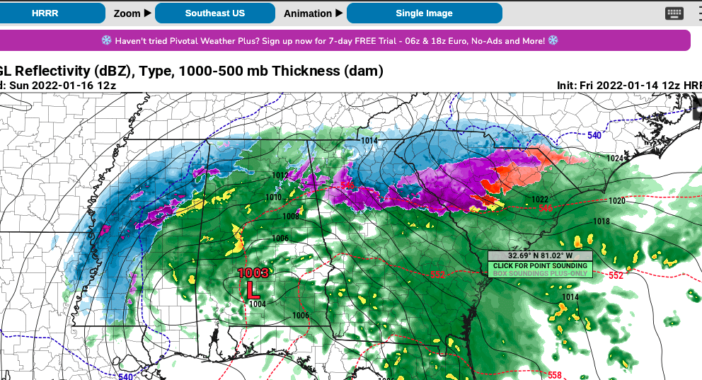
1 minute ago, burrel2 said:
Just when I think the Hrrr can't get any better; it spits out this non sense. Upstate, SC... let's go!!! I'm honestly going to be very... very surprised if Oconee/Pickens/Greenville doesn't get at least 3-4 inches at this point. The writing is on the wall, front end thump incoming!
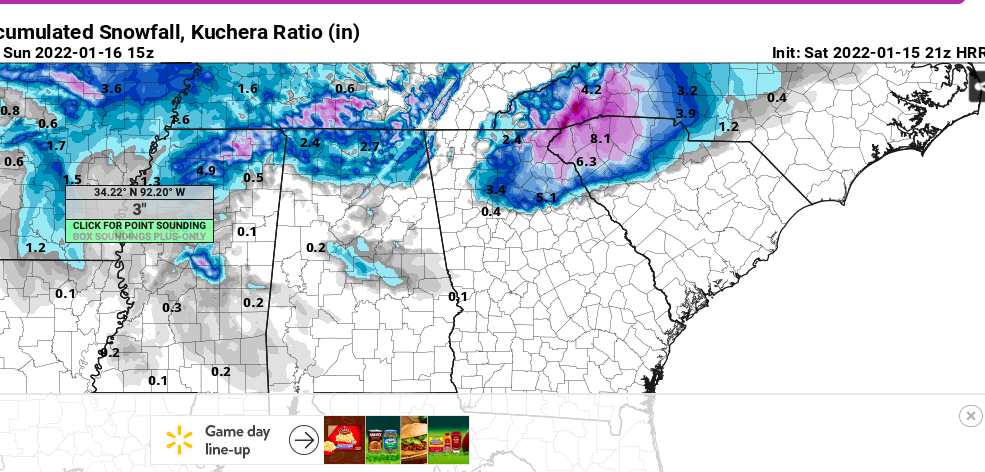
Let’s Goooooo!!!!!!
-
 2
2
-
-
5 minutes ago, Blue_Ridge_Escarpment said:
I REALLY want to believe that map! God, please let it verify!…
-
1
-
-
3 minutes ago, Blue_Ridge_Escarpment said:
21Z RAP really increased snow totals
Map?
-
3 minutes ago, burrel2 said:
Here are my post-storm notes from a few recent events.
feb 6, 2021 Miller a with -3 850s but warm boundary layer, started off as rain and 39 wetbulb, heavy rates flipped it to snow. Hrrr nailed transition and precip maxima, nam was way too warm at surface and too quick with warm nose and too dry.
feb 20, 2020 started as rain around 10:00am, mixed with snow on and off all day until it ended around 6pm. Temp started at 44 and just didn't drop fast. HRRR nailed warm nose and low level temps. short range models were a little too wet, showed .5-.8 and i got .4
Nice! Hoping it’s right for this one. Cutting those totals in half would be a great event here in Greenville!
-
1
-
-
1 minute ago, burrel2 said:
Through 8am tomorrow morning.... Western Upstate, NE GA jackpot on the Hrrr..
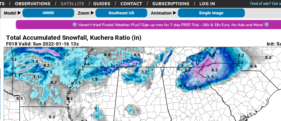
Burrel-that looms fantastic! I really want to believe that. What’s your confidence level in the Hrrr?…
-
2
-
-
26 minutes ago, BretWx said:
Was a good front end thump though.

Yeah-you know it’s wonky if its showing Greenville with more than Asheville!
-
1
-
-
1 minute ago, msuwx said:
It’s weird to me how this board can be lit up like a Christmas tree analyzing the Day 8 NAVGEM, but now that a major storm is about to hit many, many people in the region, the post frequency tails off.
Is it because the storm isn’t producing pure snow for many? Eastern NC getting the short end of the stick?
To me, this is pretty easily the most significant winter storm, per capita, in a few years.
I think that nailed it..
-
4
-
-
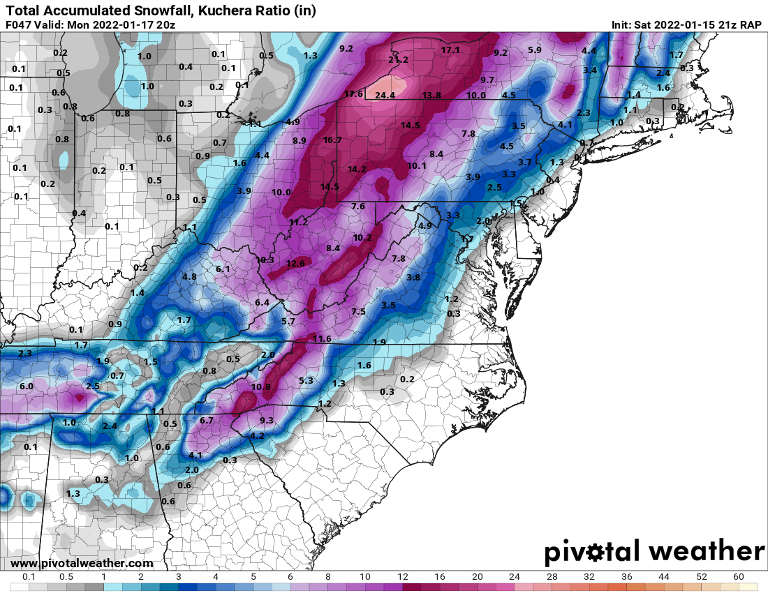
14 minutes ago, The Alchemist said:
I think the possible sweet spot zone is Highlands, Cashiers, Brevard, Zirconia, Saluda, Etowah, Dana up toward Gerton. Somebody along that line jackpots with 22 - 24 inches
Edit: unless your on Mitchell, I think 36 - 40 is almost a given up there

What part of Saluda are you in? I own a house there (Lake Hosea), just outside town limits. WOuld love to head up there this weekend but have too much here in Greenville to make it this weekend..
-
3 minutes ago, WinstonSalemArlington said:30 minutes ago, Grayman said:
How did the Euro look
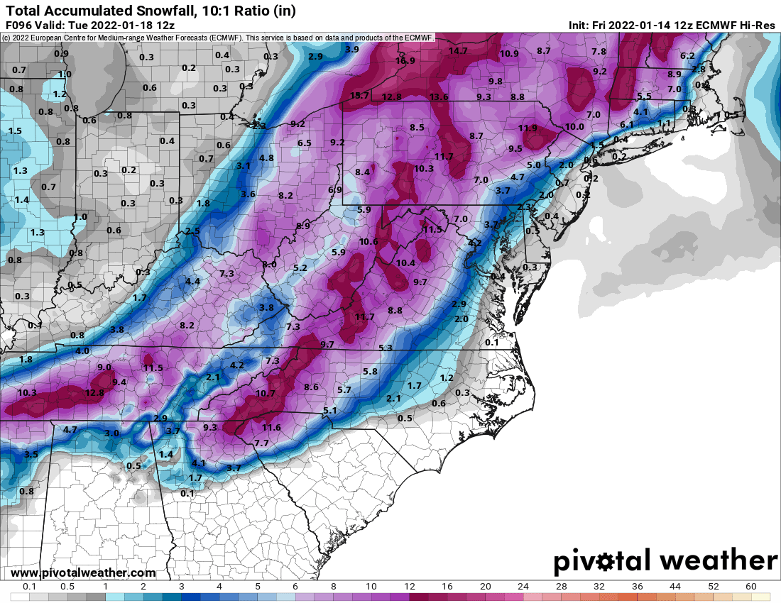
Wow! Def a western Carolina's / N GA storm! Where are all these posters???
-
1 minute ago, burrel2 said:
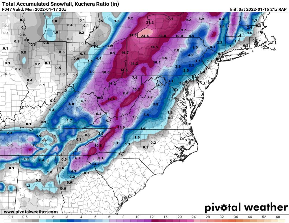
Euro is just an absolute crush job for north east Georgia and the northwestern upstate,sc.
Awesome. You have maps you could share?
-
1
-
-
Yeah-I'd much rather get the 34/cold rain than what the NAM is showing.
-
7 minutes ago, jrips27 said:
Grit posted the 1K on another board if anyone wants it
That would be a very nice front-end thump of snow in by backyard before the changeover to ice..
-
8 minutes ago, burrel2 said:
she's a beaut clark!
Yes it does! I also like the backend snow in MS..
-
1
-
-
10 minutes ago, burrel2 said:
12z Hrrr looks way more south and suppressed when comparing to the 3k NAM. 5h low is weaker and passing well south of the ark/la/tex region.
Guessing that helps keep the WAA at bay more. Maps??
-
Yeah- 4.5” with .25 sleet sounds about right here. Just hope the fz rain can be avoided here, but I know someone will get it..
-
1 minute ago, buckeyefan1 said:
Indeed

Boy-not much snow in the Carolina's in that picture! I know the backend thump still coming, but that's a lot of ice for my area..
-
I would gladly take 34 and cold rain over 30 and ice..
-
1
-
-
So me and the Mrs are going to be at Grove Park (Asheville) this weekend, leaving to come back home on Sunday morning. As of now, will I be able to get out ok, as this thing has slowed down to a Sunday morning start? Or will this be the worst time to be on the roads?
-
4 minutes ago, Sandstorm94 said:
Here

Sent from my SM-S115DL using Tapatalk
Nice run for the upstate SC folks!
-
1 minute ago, Tony Sisk said:
I've lived here for 58 years and a weather geek since grad school. Upper Level Lows that drop from the plains typically do not pan out for the upstate. Those mountains can be our friend, and sometimes our enemy. The upper level low has to drop deep enough south and west, to get the energy needed from the gulf. When it happens, it becomes a 20 year snowstorm. But those ingredients need to be a perfect storm for that. I would caution to the 1-3 inch for the time being. Which is always a thrill in the upstate. But hoping for a repeat of Jan 1987 and Jan 1988!
Yeah-I'm a 51 year resident here myself so I hear ya. 1-3" is probably more realistic..
-
2
-
 2
2
-
-
2 minutes ago, olafminesaw said:
I've learned the key too happiness is dismissing all model runs that show "the big one" and being satisfied with 2-4" that coats everything. Unfortunately knowing the key to happiness is only half the battle. I get disappointed regardless when the clown maps don't pan out, despite knowing better.
Yep. I'm in the current sweet spot, but i have full confidence we will not see the numbers these models are spitting out. 3-4" would be a great snow here in the upstate. Most models do a very poor job of predicting actual amounts..
-
3
-
-
10 hours ago, NCWX said:
I had the perfect yard 3 years ago... Then Florence hit. I think the amount of salt in the rain screwed the soil. Now I have weeds and bald spots.... I have no clue what to do. My grass was centipede. Everyones yards look the same except those who have put down new sod. I can't afford that. Any ideas?
Lime, lime, and more lime! That should neutralize the soil, and allow you to get the grass going again...
-
2
-
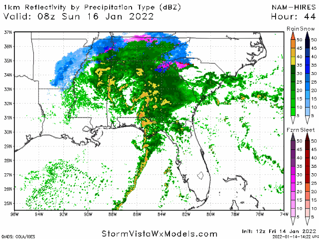
Jan 15-16 Winter Storm
in Southeastern States
Posted
Burrel, given the trends tonight on the short range models, do you think the I-85 corridor and north will avoid a lot of the fz rain, giving the Anderson/Greenwood area the greatest threat of ice?