

1900hurricane
-
Posts
1,004 -
Joined
-
Last visited
Content Type
Profiles
Blogs
Forums
American Weather
Media Demo
Store
Gallery
Posts posted by 1900hurricane
-
-
From the latest HGX discussion:
Quote.CLIMATE... Going through some rainfall data tonight and much of the area has had some impressive rainfall totals. 2016 rainfall at Cypress, Houston Westbury, Houston Bush and Baytown have all exceeded their normal annual (1981-2010) rainfall and it`s only mid September. Since January 1st 2015, Baytown has received 167.75 inches of rain which is 67.08 inches above normal over the roughly 21 month period. This location is averaging about 8 inches of rain per month over the last 21 months. 43
-
3 minutes ago, cmasty1978 said:
the airport is near the S end of the island, in or next to the eyewall. If that 9 was replaced with an 8 then the central pressure would probably be sub 870.
i think the sensor is just wonky because a super typhoon just hit it. the 883 theory is just too crazy to believe.
Yep, that's what I think too. While I won't completely dismiss the 883 mb theory, I also think it is unlikely.
-
6 minutes ago, patrick05 said:
Well the 18z report had the pressure jump back up to 983hPa (50hPa jump in 1 hour lol)... 933hPa seems pretty high given the island was under the eye for a moment... maybe it bottomed out in between reports??
also winds down to 64kph and 90kph in Itbayat and Basco, respectively... i'm afraid to see the reports out of there today, home to about 18k people
It might be a faulty report. The island was still in the eye at 18Z.

Alternatively, I've seen some speculation that the 9 should be replaced with an 8.
-
Wow, JTWC actually went up to 165 kt/887 mb for 18Z.
-
Yeah, this is really something right now.
-
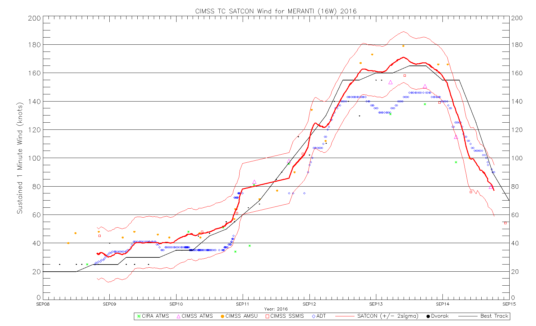
Not sure I fully buy into JTWC's 00Z intensity estimate of 160 kt. They're putting a lot of weight on SATCON for that estimate, which a notable deviation of standard policy for them. It could be correct for all I know, but the Dvorak Technique is the one with the proven track record. I know next to nothing about SATCON's verification.
-
Good morning to Super Typhoon Meranti.

-
Meranti went berserk and is now at 155 kt. Rai and Malakas are now also named in the South China Sea and near Guam, respectively.

-
It has been a somewhat slow Western Pacific Typhoon Season so far this year. The season started late in July, only four or five (depending on your choice in agency) typhoons have been observed so far, and ACE still remains a fair bit below 100*10^4 kt^2. Things may be changing though, especially with La Nina struggling to develop. At the time of this original post, Tropical Storm Meranti has just developed, and it may go on to be a very powerful typhoon.
WV loop above will continue to update and stay current.
-
The Pacific jet showing up in medium range guidance sure is nice looking. As others have alluded to across various media, this could help make things rather active later on in June.
-
Looks like today's 12Z GFS and ECMWF runs highlight two different return flow scenarios. This run of the ECMWF looks considerably more robust with its modeled warm sector when compared to this particular GFS run. The 570 dam thickness of the former lies across Texas while the latter depicts it still well offshore in the Gulf. Lots of variability still.


Sent from my iPhone using Tapatalk
-
Maybe one last chance for 2015?
-
Instability looks rather low, what was once looking like a solid warm sector has shrunk into almost nothing.
I'll be honest and say I haven't really looked much at anything other than the standard height plots up to this point, but I can see how that could be an issue. Having the current system shear out and leave some junk behind for a few days certainly doesn't help things at the surface with return flow. I'll still be watching it though, and if the models don't shift anything around with the timing, I'm actually probably good to go Wednesday if things look good at that point.
*EDIT: Just looked at the 12Z ECMWF CAPE for Wednesday. Ick, I can see what you mean...
-
So, the last few ECMWF runs have looked interesting about 6 days out.
-
I can't say I've really looked at this with great detail, but the way things have been playing out this year does somewhat remind me of 1957. Both this year and 1957 can be described as El Nino springs with the southern plains transitioning from a very bad drought to flooding due to craploads of rain.
-
Random question, but does anyone know why the SPC has been consistent in putting "Potential Too Low" over the past few days? Especially today, it's thrown me off a little.
-
As am I. Even at the tail end of fantasyland for most of the operational models, the change is already starting to be picked up on. It might be time for me to start looking at my schedule and seeing what I might need to do to free up a day in the future.
-
Last couple of ECMWF runs have been trying to bring a huge piece of energy down in the west at the end of the forecast cycle. That might be something to watch coming up and could also be the harbinger of the oft-mentioned pattern change.
-
Eight or so days out looks fun. ECMWF has been really consistent showing a strong trough ejecting into the plains despite the range.
-
Pretty good WPC Extended forecast discussion this morning talking about pattern change and the emergence of the Subtropical Jet.
EXTENDED FORECAST DISCUSSION
NWS WEATHER PREDICTION CENTER COLLEGE PARK MD
155 AM EST TUE DEC 02 2014
VALID 12Z FRI DEC 05 2014 - 12Z TUE DEC 09 2014
...OVERVIEW/SENSIBLE WEATHER HIGHLIGHTS...
AN ACTIVE WEATHER PATTERN FOR THE WEST COAST AND WESTERN INTERIOR
THIS MEDIUM RANGE PERIOD...WITH AN INCREASED FREQUENCY OF PACIFIC
SHORTWAVE ENERGY DELIVERING PERIODS OF WIND AND PRECIPITATION.
DOWNSTREAM OF THE CONTINENTAL DIVIDE...A LOW-AMPLITUDE NORTHERN
STREAM FLOW SHOULD DELIVER OCCASIONAL...BUT BRIEF SURGES OF
COLD...CANADIAN AIR TO THE NORTHERN PLAINS...GREAT LAKES...AND NEW
ENGLAND DURING THE FIRST HALF OF THE FORECAST PERIOD. THE
LOW-AMPLITUDE NATURE OF THIS NORTHERN STREAM ENERGY IS EXPECTED TO
DELIVER PERIODS OF LIGHT PRECIPITATION FOR THE MIDWEST...OHIO
VALLEY AND MID-ATLANTIC STATES.
AFTER DAY 4...THE SOUTHERN BRANCH OF THE PACIFIC JET STREAM
BECOMES ACTIVE. MORE WIND THAN RAIN FOR THE DESERT SOUTHWEST---THE
WETTER PATTERN EMERGING DOWNSTREAM FOR TEXAS...THE SOUTHEAST AND
PIEDMONT.
...MODEL PREFERENCES/UNCERTAINTY ASSESSMENT...
THE FORECAST PHILOSOPHY REMAINS THE SAME...WITH THE 1/12Z
ECENS-GEFS AND NAEFS MAINTAINING A STEADY STREAM OF WESTERLIES
ALONG 40N LATITUDE FROM COAST TO COAST...AND A RATHER FAST-MOVING
BUT LOW-AMPLITUDE WAVE PATTERN DOWNSTREAM OF THE CONTINENTAL
DIVIDE. THE EAST CENTRAL PACIFIC CONTINUES TO PROJECT AN ACTIVE
SERIES OF CYCLONE MIGRATIONS FROM 170W TO 130W...AND WHAT IS
BECOMING MORE EVIDENT...IS THE LATITUDE FOR THE WAVE TRAIN
MIGRATION. TO ME---IT'S DISPLACED SOUTH OF A 'TYPICAL' LATE-AUTUMN
LATITUDE---CLOSER TO 40N-42N THAN 47N-48N ALONG 140W LONGITUDE. IF
THE ECENS MEAN IS ANY INDICATION OF WHAT CAN BE EXPECTED...ITS
1/12Z DETERMINISTIC RUN AND 250MB JET FORECAST SHOULD BE NOTED
FROM THE SOUTH COAST OF JAPAN TO 40N 140W BY THE END OF DAY 7.
A SECOND FEATURE OF THE PACIFIC---IS THE EARLY EMERGENCE OF THE
SUBTROPICAL JET...AND ACTIVE OVER NORTHERN MEXICO SO EARLY IN THE
LOW-SUN HALF OF THE YEAR. THIS IS USUALLY MORE A LATE JANUARY
THROUGH FEBRUARY OBSERVANCE. AND WITH THE DETERMINISTIC GUIDANCE
SUGGESTING NOTABLE INCREASES IN THE PACIFIC BRANCH OF A JET NEAR
25N...IN CLOSE PROXIMITY TO HAWAI'I NORTHEASTWARD INTO NORTHERN
MEXICO BY THE END OF DAY 7...AM THINKING THIS MEDIUM RANGE
FORECAST PERIOD IS TRYING TO TELL US SOMETHING---AND PERHAPS THE
PATTERN IS CHANGING IN EARNEST...WITH THE DOWNSTREAM EJECTION OF
THE CLOSED LOW OFF THE CALIFORNIA COAST SETTING THINGS INTO MOTION.
CANNOT RULE OUT THE 1/12Z DETERMINISTIC ECMWF---CANADIAN OR GFS AT
DAY 5---WHEN THE FOCUS TRANSITIONS FROM NORTHERN BRANCH TO
SOUTHERN BRANCH. TIMING THIS SEEMS LESS AN ISSUE. THE SOUTHERN
CURRENT BECOMES A PREVAILING AND DOMINANT FEATURE OF THE
UPPER-LEVEL FLOW PATTERN ACROSS THE SOUTHERN TIER STATES FOR THE
REMAINDER OF THE MEDIUM RANGE---AND PROBABLY BEYOND.
THERE ARE TWO POINTS OF CONTENTION BETWEEN THE DETERMINISTIC
GUIDANCE. EARLY IN THE PERIOD...DOES THE CLOSED LOW WEST OF
CALIFORNIA REMAIN INTACT OR SIMPLY SHEAR APART OVER THE DIVIDE?
THE SECOND POINT FOR CONTENTION...ONCE THE SOUTHERN JET MOVES INTO
THE SOUTHERN TIER STATES...DOES IT PHASE WITH THE NORTHERN
BRANCH...AND IF SO...AT WHAT LONGITUDE IN THE WESTERN ATLANTIC
WILL THE PHASING TAKE PLACE. WITH THE REMNANT CLOSED LOW NEEDING
TO MOVE THROUGH THE NORTHERN STREAM INITIALLY BEFORE A SOUTHERN
STREAM CAN FOLLOW IN BEHIND THE DEPARTING CUTOFF---AND TO ITS
SOUTH...A BLEND OF THE MEANS MIGHT BE THE WAY TO GO FOR DAYS 5-7.
IN THE PACIFIC...THE DETERMINISTIC GUIDANCE IS ESTABLISHING A
RATHER SOLID CONSENSUS WITH THE DEPTH AND BREATH OF THE 250MB JET
AXIS---ALONG AND SOUTH OF 40N LATITUDE. HERE...I THINK ALL THREE
MEANS WILL ALLOW THE MIGRATION OF A MODERATE MID-LEVEL TROUGH
ACROSS 30N-35N INVOF 120W (BETWEEN 6/00Z AND 7/12Z) SET THE
DOWNSTREAM PATTERN IN MOTION ACROSS THE SOUTHERN TIER.
VOJTESAK -
Looks like a pretty pronounced split flow regime will likely establish itself for the first half of December, particularly for the second week. That week, medium-range guidance is placing a ridge over the northern part of the CONUS and into Canada on top of a trough in the Southwest. Looks like a pretty warm pattern with the potential for some good rain across the southern plains, although the European guidance is much less amplified with the southern stream.


Sent from my iPhone using Tapatalk
-
Yep, I've been keeping an eye on it as well. I missed andyhb's post with the convective outlook in the Texas thread, but I figure I'll post it over here if just for posterity's sake. Predictability Too Low >> Probability Too Low any day of the year.

ZCZC SPCSWOD48 ALL
ACUS48 KWNS 171000
SPC AC 171000
DAY 4-8 CONVECTIVE OUTLOOK
NWS STORM PREDICTION CENTER NORMAN OK
0400 AM CST MON NOV 17 2014
VALID 201200Z - 251200Z
...DISCUSSION...
MODEL CONSENSUS IS THAT UPPER PATTERN WILL BEGIN TO DEAMPLIFY BY
THURSDAY /DAY 4/ AND TRANSITION TO A MORE PROGRESSIVE REGIME WITH
SEVERAL LOWER-LATITUDE IMPULSES EXPECTED TO MOVE THROUGH THE SRN
THIRD OF THE COUNTRY. AN INITIAL LOW-AMPLITUDE SHORTWAVE TROUGH
SHOULD MOVE THROUGH THE SRN PLAINS AND LOWER MS VALLEY
THURSDAY...BUT IT CURRENTLY APPEARS MOISTURE RETURN WILL REMAIN
SOMEWHAT LIMITED FOR AN ENHANCED SEVERE THREAT.
FRIDAY /DAY 5/ COLD FRONT IS EXPECTED TO MOVE SWD TOWARD THE COAST
AS SHORTWAVE RIDGING BUILDS OVER THE SRN PLAINS.
SATURDAY /DAY 6/ MODELS HAVE TRENDED TOWARD SIMILAR SOLUTIONS WITH
SPEED AND AMPLITUDE OF A MORE SUBSTANTIAL SHORTWAVE TROUGH THAT WILL
MOVE INTO THE SRN PLAINS SATURDAY AND CONTINUE INTO THE MS VALLEY
LATER SATURDAY NIGHT. GIVEN THE ANTECEDENT FRONT IS NOT EXPECTED TO
PENETRATE THE GULF...MORE SUBSTANTIAL MOISTURE RETURN AND
INSTABILITY SHOULD OCCUR IN ADVANCE OF THIS FEATURE SUPPORTING
POTENTIAL FOR A MORE ROBUST SEVERE THREAT FROM TX INTO A PORTION OF
THE LOWER MS VALLEY. AN ENHANCED SEVERE RISK AREA WILL LIKELY BE
INTRODUCED ON THE NEXT 4-8 UPDATE FOR A PORTION OF THIS REGION IF
MODEL ENSEMBLES CONTINUE TO DEMONSTRATE CONSISTENCY.
FOR DAYS 7-8 SOME SEVERE THREAT WILL PROBABLY DEVELOP THROUGH SRN
PORTIONS OF THE GULF COAST STATES AND INTO THE CAROLINAS.
..DIAL.. 11/17/2014 -
Looking ahead some, the next trough should start carving itself out across the central part of the country this weekend and going into next week. Of particular interest to me is the initial shortwave disturbance currently progged to eject into the southern plains Saturday. Even though the airmass across the southern plains and lower Mississippi Valley is going to need some major modification between now and then, guidance seems to think enough time will elapse to offer up some surface instability in the warm sector of the developing storm system. With adequate surface instability and wintertime dynamics, it looks like we might have our first real chance at some severe weather in quite a while.
-
I almost hate to mention it with so much uncertainty almost a week out, but the recent ECMWF solution shows some similarity to the system from November 1992. I highly doubt something near that magnitude will occur, but it certainly has intrigue. It'll be interesting to see how the solutions evolve over the next several days.
WPAC, Indian Ocean, and Southern Hemisphere Tropical Cyclones
in Tropical Headquarters
Posted
The typical JTWC biases are actually to be too low when a storm is strengthening or near peak intensity and then constrain the storm too high once it has begun weakening. The 2015 Typhoon Season was actually stripped of about 20*10^4 kt^2 between the operational and final best track data largely because of over-constraining a weakening storm.
However, in this case I'd say JTWC's intensity estimate was pretty good. Keep in mind that in order to make a real time intensity estimate (in this case, at 18Z), only the data up to that point is available to be used, so in this case, the data mainly used came from between 12Z and 18Z (images below are from 1650Z).