

schoeppeya
-
Posts
579 -
Joined
-
Last visited
Content Type
Profiles
Blogs
Forums
American Weather
Media Demo
Store
Gallery
Everything posted by schoeppeya
-
MO/KS/AR/OK 2024-2025 Winter Discussion
schoeppeya replied to JoMo's topic in Central/Western States
Finally moderate to heavy snow here, hopefully can squeeze a couple inches out of it. -
MO/KS/AR/OK 2024-2025 Winter Discussion
schoeppeya replied to JoMo's topic in Central/Western States
Ill own it, and it won't be the first time its felt like I have singlehandedly jinxed a big event -
MO/KS/AR/OK 2024-2025 Winter Discussion
schoeppeya replied to JoMo's topic in Central/Western States
Absolutely classic that we immediately started trending away from the high end solutions after this post -
MO/KS/AR/OK 2024-2025 Winter Discussion
schoeppeya replied to JoMo's topic in Central/Western States
The CAMS are still very insistent that we get to 3-5" in Tulsa so guess we will see... I'd feel pretty good if I was in NWA/SW Mo still -
MO/KS/AR/OK 2024-2025 Winter Discussion
schoeppeya replied to JoMo's topic in Central/Western States
We aren't even close to an inch yet in Tulsa, at this point I don't know if we are going to get enough to even take the kids sledding. -
MO/KS/AR/OK 2024-2025 Winter Discussion
schoeppeya replied to JoMo's topic in Central/Western States
HRRR has it filling in very quickly over the next hour or two -
MO/KS/AR/OK 2024-2025 Winter Discussion
schoeppeya replied to JoMo's topic in Central/Western States
Same. I don't want to jump the gun on calling a bust but im starting to feel like we would be lucky to get 6" in Tulsa. We are still getting freezing rain on the south side of town so still pretty ugly regardless. -
MO/KS/AR/OK 2024-2025 Winter Discussion
schoeppeya replied to JoMo's topic in Central/Western States
Pretty unbelievable, I'm in Bixby and we have been getting freezing rain for a few hours and you couldn't pay me enough money to get out on the roads right now. -
MO/KS/AR/OK 2024-2025 Winter Discussion
schoeppeya replied to JoMo's topic in Central/Western States
I dont know that moods soured but the short term trends arent QUITE as favorable as after the 18z suite -
MO/KS/AR/OK 2024-2025 Winter Discussion
schoeppeya replied to JoMo's topic in Central/Western States
Notable reduction in QPF on a lot of the 0z models right after the increase on the 18z runs -
MO/KS/AR/OK 2024-2025 Winter Discussion
schoeppeya replied to JoMo's topic in Central/Western States
I think you could draw a rough oval from independence to tulsa to mountain home to springfield to pittsburg and say anyone inside that could is looking at 8-12"+ depending on where the heaviest bands verify. -
MO/KS/AR/OK 2024-2025 Winter Discussion
schoeppeya replied to JoMo's topic in Central/Western States
I'm finally letting myself buy in now that we are 12ish hours from the start and trends are increasing totals if anything. Looking like it's going to be the biggest snow since Feb 2011 followed by deep, deep cold. Hope everybody gets the goods and enjoys this once in every 15- or 20-year type event. -
MO/KS/AR/OK 2024-2025 Winter Discussion
schoeppeya replied to JoMo's topic in Central/Western States
NAM came south again too. NEOK bullseye -
MO/KS/AR/OK 2024-2025 Winter Discussion
schoeppeya replied to JoMo's topic in Central/Western States
Doubled QPF/snowfall totals for places just north of Tulsa like Bville, loving the trend. -
MO/KS/AR/OK 2024-2025 Winter Discussion
schoeppeya replied to JoMo's topic in Central/Western States
Definitely a step towards the Icon/Canadian. Still about ten degrees warmer which seems like a significant difference at this range. -
MO/KS/AR/OK 2024-2025 Winter Discussion
schoeppeya replied to JoMo's topic in Central/Western States
GFS an outlier on temps at this point with highs 10ish degrees higher for Tulsa on Wednesday and Thursday than the other models . -
MO/KS/AR/OK 2024-2025 Winter Discussion
schoeppeya replied to JoMo's topic in Central/Western States
It’s been TERRIBLE this year outside of 24 hours and even then, still not good. . -
MO/KS/AR/OK 2024-2025 Winter Discussion
schoeppeya replied to JoMo's topic in Central/Western States
Temps after the snow are pretty unbelievable with the models showing the deeper snow further south suggesting Tulsa could have 2 days of single digit highs. Id imagine the typical cold spots like Nowata will have some lows well below zero. -
MO/KS/AR/OK 2024-2025 Winter Discussion
schoeppeya replied to JoMo's topic in Central/Western States
Around 7 in the south Tulsa burbs, still snowing. Over performed for sure. -
MO/KS/AR/OK 2024-2025 Winter Discussion
schoeppeya replied to JoMo's topic in Central/Western States
Haven’t given up hope in Tulsa, in the time frame we usually start to see the final shifts and trends take place… another jump south like the 0z euro and we’d at least be on the north side of the low. . -
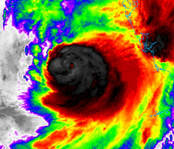
Givin the current forward speed we are only about 3 hours from the outer edges of the eyewall impacting land. Seems early.
-
I am impressed with how the eye has centered itself within the convection given the shear
-
Agreed. At least to this point, the degraded IR presentation looks to be more from an ERWC than from shear blasting the core. As others have pointed out, the models that degrade the storm rapidly basically dissipate the southern half of the storm due to dry air and looking at lower level water vapor imagery im just not seeing the dry air to the south of the storm for shear to push in yet. I also don’t see how this doesn’t make landfall significantly earlier than it looked last night
-
What exactly are the decreasing threats? This is still a 155 mph cat 4 that is right on track with intensity expectations and encountering shear as has been widely discussed for 48 hours. It may well end up weaker then expected but high end impacts are baked in at this point
-
Those supercells that are offshore are going to be a really, really bad situation.


