NycStormChaser
-
Posts
2,374 -
Joined
-
Last visited
Content Type
Profiles
Blogs
Forums
American Weather
Media Demo
Store
Gallery
Everything posted by NycStormChaser
-

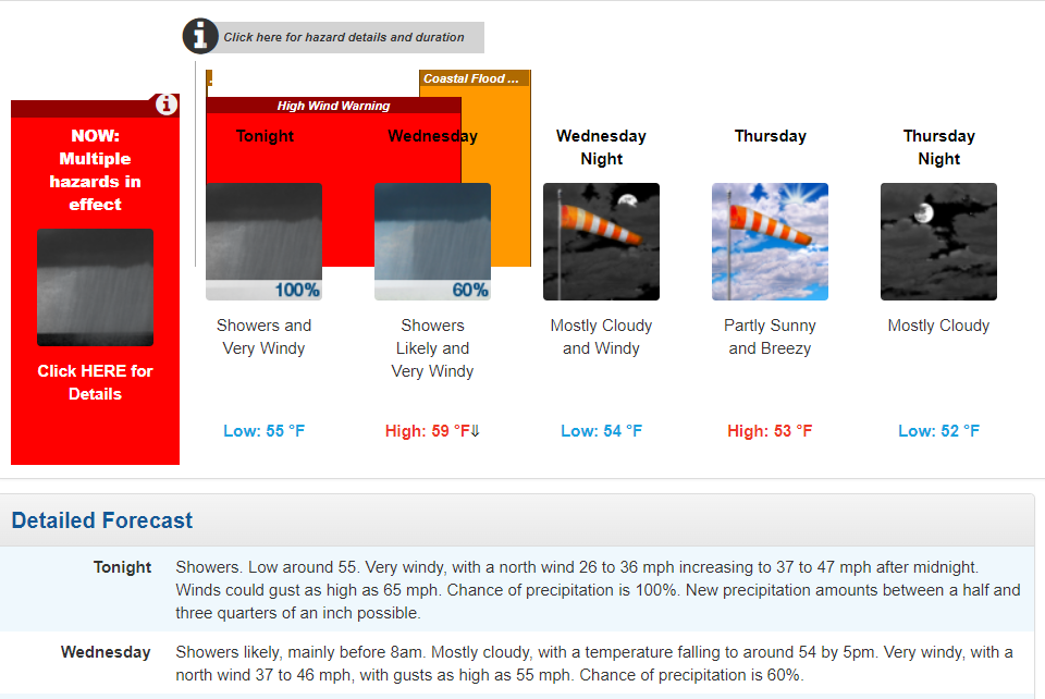
OBS and nowcast 9PM tonight-8A Wednesday for a general 2-5" rain, isolated 8" possible. 40-60 kt damaging wind likely Tuesday-early Wednesday. Focus for damaging wind and heaviest rain is the I95 corridor to the coasts. Power outages esp CT LI.
NycStormChaser replied to wdrag's topic in New York City Metro
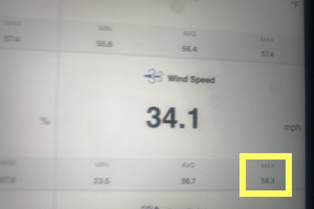
Highest gust so far is 58.3 MPH
- 228 replies
-
- 1
-

-
- heavy rain
- flash flooding
- (and 2 more)
-
OBS and nowcast 9PM tonight-8A Wednesday for a general 2-5" rain, isolated 8" possible. 40-60 kt damaging wind likely Tuesday-early Wednesday. Focus for damaging wind and heaviest rain is the I95 corridor to the coasts. Power outages esp CT LI.
NycStormChaser replied to wdrag's topic in New York City Metro
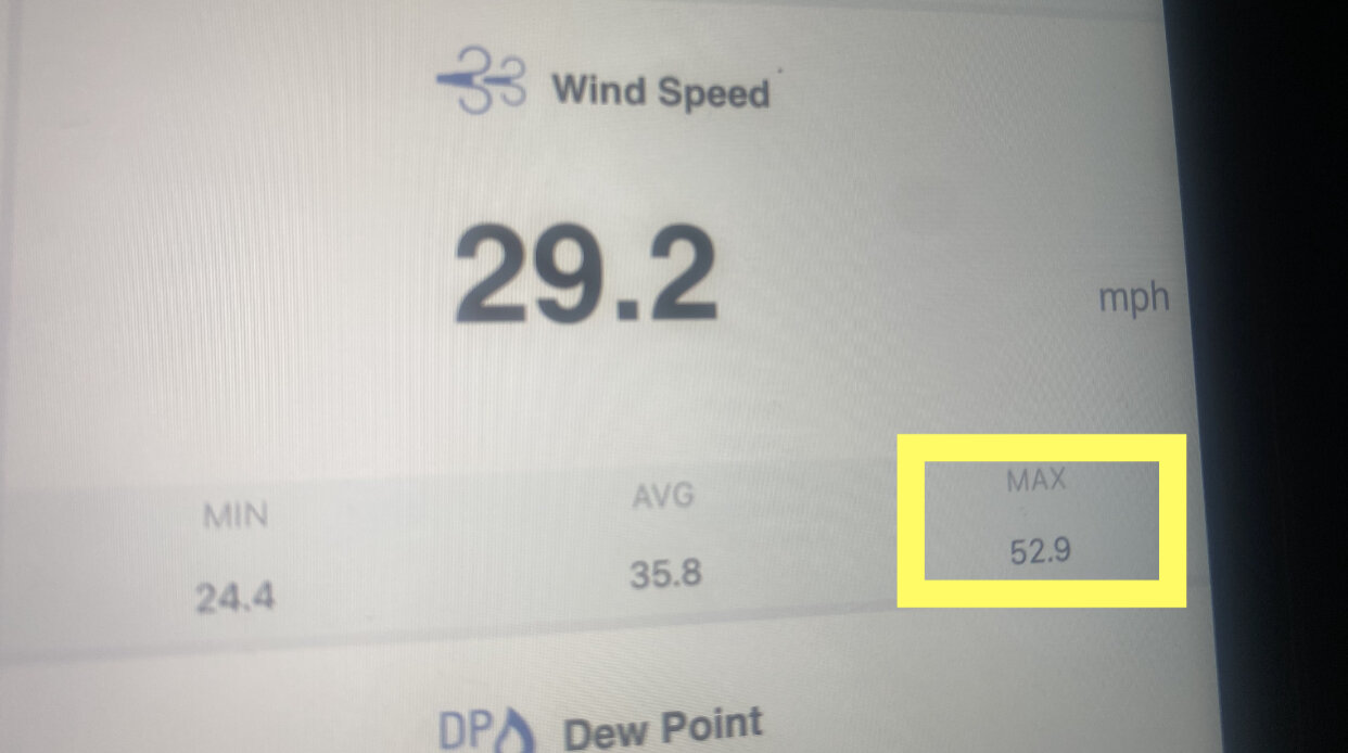
Got to Montauk at 5am. Highest gust so far is 52.9
- 228 replies
-
- 1
-
-
- heavy rain
- flash flooding
- (and 2 more)
-
Most of Isaias wind gusts were in the 50s and 60s across long island minus one or two in the 70s
- 306 replies
-
- 1
-
-
- heavy rain
- damaging wind
- (and 1 more)
-
I'll be heading out to Montauk shortly, should be fun.
- 306 replies
-
- 1
-
-
- heavy rain
- damaging wind
- (and 1 more)
-
OBS and nowcast 9PM tonight-8A Wednesday for a general 2-5" rain, isolated 8" possible. 40-60 kt damaging wind likely Tuesday-early Wednesday. Focus for damaging wind and heaviest rain is the I95 corridor to the coasts. Power outages esp CT LI.
NycStormChaser replied to wdrag's topic in New York City Metro
They issued that this morning. They updated the text this afternoon. -
OBS and nowcast 9PM tonight-8A Wednesday for a general 2-5" rain, isolated 8" possible. 40-60 kt damaging wind likely Tuesday-early Wednesday. Focus for damaging wind and heaviest rain is the I95 corridor to the coasts. Power outages esp CT LI.
NycStormChaser replied to wdrag's topic in New York City Metro
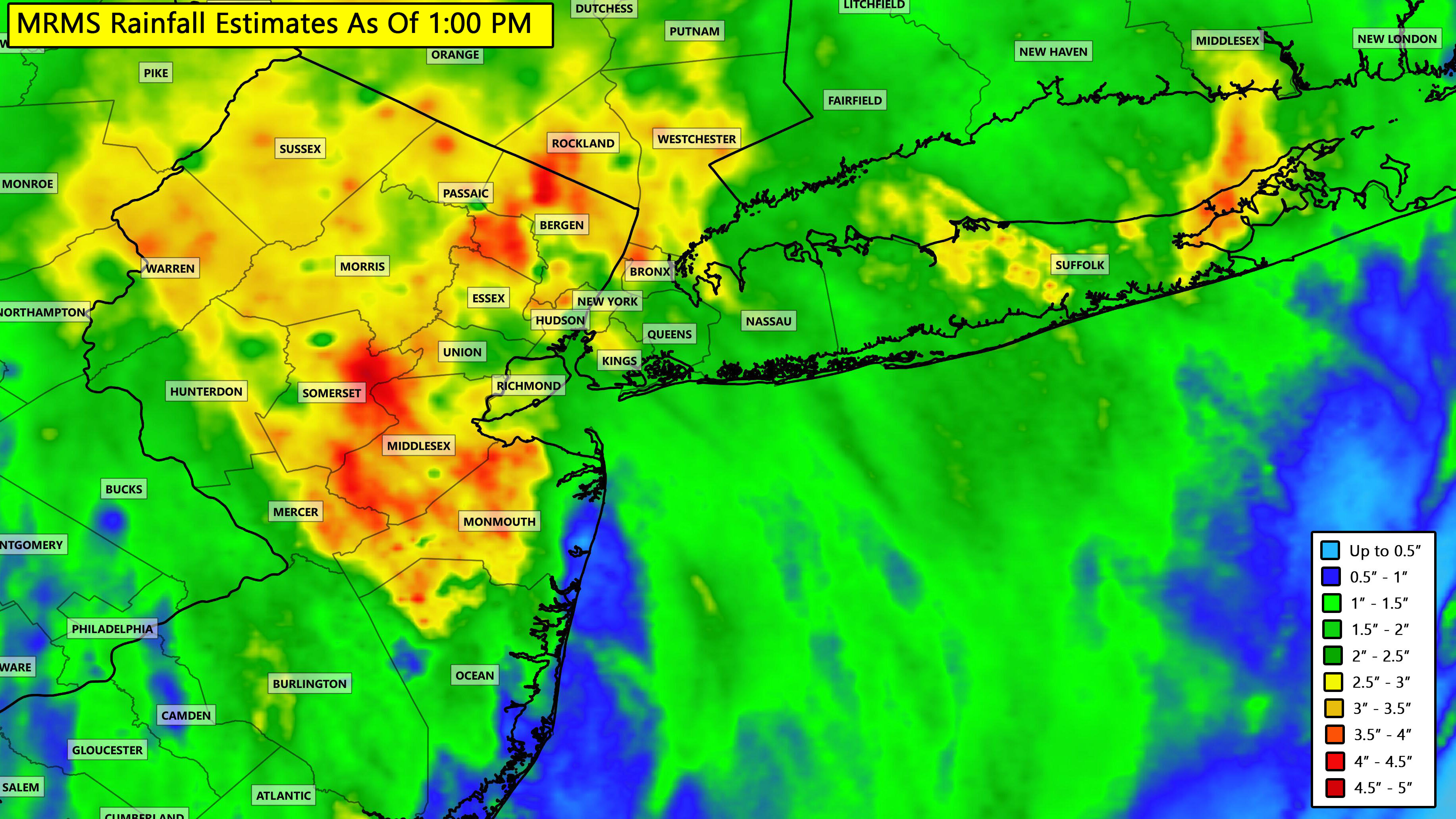
Current rainfall totals as of 1:00 PM
-
OBS and nowcast 9PM tonight-8A Wednesday for a general 2-5" rain, isolated 8" possible. 40-60 kt damaging wind likely Tuesday-early Wednesday. Focus for damaging wind and heaviest rain is the I95 corridor to the coasts. Power outages esp CT LI.
NycStormChaser replied to wdrag's topic in New York City Metro
Invest 94L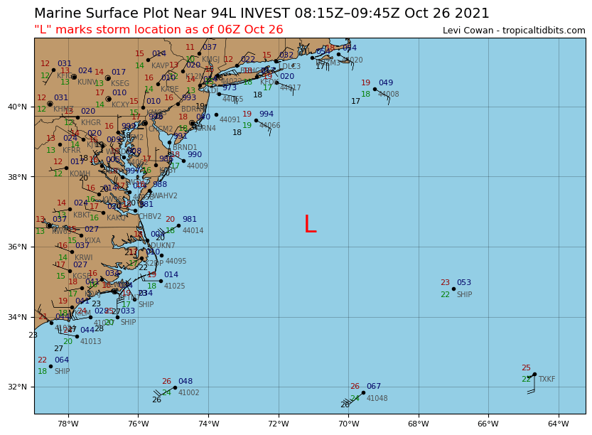
- 228 replies
-
- 1
-
-
- heavy rain
- flash flooding
- (and 2 more)
-
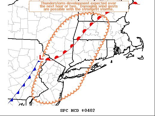
https://www.spc.noaa.gov/products/md/md0402.html
-
I think this was always a threat for NYC / NE NJ into the Hudson Valley. Long Island was never really in the game.
-
Possible Major Winter Storm/Coastal 3/6 - 3/8
NycStormChaser replied to Northof78's topic in New York City Metro
Better for photography :-) -
Possible Major Winter Storm/Coastal 3/6 - 3/8
NycStormChaser replied to Northof78's topic in New York City Metro
Yep. I was in a heavy snowstorm last May in the Catskills. -
NYC will definitely have frequent gusts at 35mph or higher for 3 hours. Not sure if they issue a warning though.
- 3,762 replies
-
- 2
-
-
- heavy snow
- heavy rain
- (and 3 more)
-
Looking back at the past year, one of my favorite chase days of 2019 was May 28th in New Jersey. My chase partner Michael Koch and I were positioning ourselves for a tornado warned cell to our west that already put down a tornado in Pennsylvania when the storm right in front of us decided to drop a tornado as well. We heard the storm start to make a distinct sound and we knew a tornado was on the ground as power flashes began across Lake Hopatcong. We followed the storm as tornado warnings continued all the way to New York City and got to see lighting strike after strike over the skyline. .
-
Vendor, Blog and TV Channel Forecasts Thread Part 2
NycStormChaser replied to Rjay's topic in New York City Metro
NY1...
-
Pam. Not William.
-
Give it up already dude
-
.....
-
But at least people can go to battery park and enjoy themselves. The Hudson has all that park property along the West side highway. From battery park you would have great views from Staten Island, Brooklyn and NJ. People still watch fireworks from Battery Park and Brooklyn. Jersey city began doing their own fireworks show a few years ago when the Macy's firework show was moved from the Hudson River back to the East River. They go off at the same time and are just as long in duration. It's pretty cool watching both from jersey go off at the same time.
-
My wedding is Sunday in Port Jeff. Hoping it doesn't rain for the ceremony at 4 which is outside. After that I'm not too concerned as the reception is indoors.
-
I'll take rain on the 4th if it's clear on the 3rd for my wedding
-
They got a foot of rain. That's crazy. My uncle works in Islip as a tow truck driver. He had to drive east to work on the westbound lanes of the southern state parkway this morning. Eastbound lanes were too flooded.