
Torchageddon
-
Posts
1,467 -
Joined
-
Last visited
Content Type
Profiles
Blogs
Forums
American Weather
Media Demo
Store
Gallery
Posts posted by Torchageddon
-
-
Woke up to dense overcast, gloomy. Not forecast and now there is blow-off from the cells over N MI
 . In a turn of events, TWN forecast had a huge jump in my highs for today and the next 3 days showing 30C tomorrow (!) and more humidity. Hourly depicts 11am the temp to soar to 29 by 4pm and stay that way til dusk. I would normally be thrilled but this damn overcast. Next week they lowered my highs a tad when guidance was going to other way. Then with the overcast it shows currently mainly sunny. I should just disregard everything once more if they can't even get that right.
EDIT: I'm going up 1C every 5-10 mins now, last 1C was in 5 mins; the rocket is taking off
") First 30C of 2022 in store?
First 30C of 2022 in store?
-
 1
1
-
-
2 hours ago, Snowstorms said:
How is midwestern Ontario in the mid 20's but Toronto can't even crack 20C?


For my American friends, 20C is 68F. We haven't even hit that yet.
I couldn't believe it so I checked; 19C still!
 The east wind taketh away.
-
 1
1
-
-
On 5/5/2022 at 10:18 AM, Torchageddon said:
When I checked my 7-day I was stunned to see this:

And today has also been changed to full sun no clouds! I'd happily trade more intense heat for something historic like this - I don't see this happening but its a major step in a positive direction
 . I had 7 days of no clouds during a period in June 2020 helped by less aircraft flying.
Too bad that was just a (predictable) fantasy. 15 Hrs of sun per day = pipe dream. I think last night the skies were partly obscured by wildfire smoke.
So far I'm at 27C/81F / 3C/37F - RH is very low at 20%. Still a stiff breeze from the south. Very good but 29C with this dewpoint and winds is perfect for me.
-
Updated 7-day, they lowered tomorrow's high to 22C!
I love these guys, busting too low by 4 today then lowers the start of the real deal  . Changed the weekend to chance of storms both days.
-
I'm up to 25C/78F so far, that's 4C higher than what TWN is showing. This is the second day of summer here.
-
 1
1
-
-

I can't find a cloud in this frame, this is rare.
On another note, my forecast is trending in the wrong direction

-
1
-
-
I should've known TWN was full of it, yesterday it just clouded right up to a overcast after 4pm so a forecast for the day (hours really) completely busted and it wasn't even a close call. This morning was cloudy but it had partly cloudy in there anyways then became sunny.
My 14 day from said entity which is for entertainment only, shows no precip at all which is exceptionally rare for May here. It shows even for the back-half of the 14 days mostly sun. Seeing as how the engine can't even forecast clouds hours from now, I'm back to wanting the intense heat.
-
1
-
-
1 hour ago, A-L-E-K said:
sorry about the brown dusty climo powerball
we're about to enter paradise mode
Good phrase, it had to happen after these last few months.
1 hour ago, hardypalmguy said:Latest model suite is really suppressing the heat next week. No more torch.
I'm a "the hotter the better" type guy but even I don't mind foregoing the heat if it means endless sun for 8-10 days, just as long as its comfy. I also have a feeling it would prevent a rubberband snap to the opposite as has been historically common. This GFS accumulated precip map is extraordinary:

-
When I checked my 7-day I was stunned to see this:
And today has also been changed to full sun no clouds! I'd happily trade more intense heat for something historic like this - I don't see this happening but its a major step in a positive direction
. I had 7 days of no clouds during a period in June 2020 helped by less aircraft flying.
-
 1
1
-
1
-
-

This is a cool tornado, vortices would spin up out of nowhere and dissipate just as fast.
-
On the CFS dashboard the chiclets are getting feisty with a rare 3 day red-x streak for nearly 4 runs - with some dark reds every other day before said period. It sniffed out that memorable TX day earlier this spring (Taylor) 11 days out. I've been watching that May 8-11 period for a while now.

If there was ever a time to get a bingo on the SPC dashboard this was it, surprised and disappointed Broyles didn't outline due to a lack of large-scale ascent those Days 7-8.

The first dark red-x 372-396 hours before May 11-12:

We'll see how close it was to the outcome.
-
I have ptwd - post traumatic winter disorder. The difference is mine goes away during the summer where I have little memory of how bad things can get and always believe the lie that I can overcome winter's blah mind-numbs.
-
7 minutes ago, hawkeye_wx said:
The Canadian is all in on the heat.
Do you mean the model or me?
-
1
-
-
3 minutes ago, hardypalmguy said:
Don't get too excited. GFS is the light beer version of that at best.
I just checked the GFS, I'm just relived that it has the GLs deep into the reds too. Its hard to have crappy overcast skies in such a regime.
-

I'm going to be playing this game again, next Tue is not going to be 21C but more like 28C with a 30C possible. I'd lean to my first 30C reading of the year occurring during next week's heat being a certainty. I can't believe PMX's medium-range forecasts are this bad!
-

That's more like it.
-
1
-
-
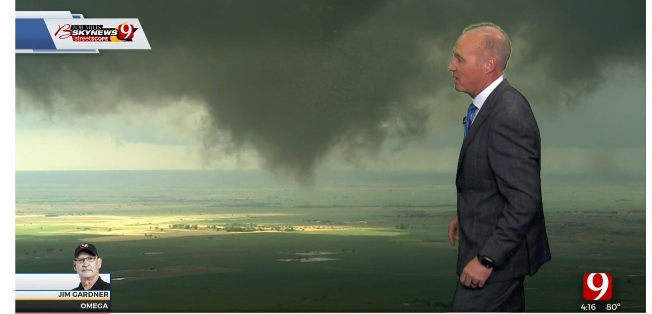
8 minutes ago, Chinook said:
I haven't had a whole lot of reasons to watch the Oklahoma City TV stations since May 2013, when of course the helicopter crew caught the developing Moore tornado. And I think there was something on the May 30th or 31st in that same year.
I recall it being after 2013, likely 2015. It was some gorgeous heli shots (from stated media) of weak tornadoes with sun-rays lighting parts of the landscape.
-
13 minutes ago, Chinook said:
yeah, watonga, Loyal, real brief tornado, as they said on the air at maybe 4:15 central time

Weird, just before I saw this that scene is exactly what I'd imagined it'd be - like a few other OK tor days.
-
For those in SE MI how much sunlight was there from Thurs-Sat? I saw some cirrus hanging around close but I didn't have mine til later Sat. Considering the nightmare we're in I was surprised I got that much sun those 3 days which gives me pause.
-
I lol'd at the tags for this one, as long as its sunny this month I do mind.
-
Its weird but wonderful waking up to clear blue skies morning after morning, I'm not getting those mid-day slumps anymore and I'm more on the ball. I do have a thin layer of cirrus from the low in the mid-west. Hoping to get over 20C today as the forecast under-estimates during these diurnal swing periods. Likely had the largest swing of the season; -1C overnight.
-
1
-
1
-
-
Even though I checked things a few hours ago I missed the historic tornado, fascinating that its behavior had characteristics to the Wynnewood EF4 and also had a likeness to it on the ground! Briefly it reminded me of the Andover tornado of 1991. How come there was only one post in here while it was actually in progress? Catch that many off guard?
https://twitter.com/Tornadof123/status/1520236918822567938?s=20&t=BQwSLNwFJdGf1CR72vaMFg
-

It seems there needs to be a lot of cloud cover in the Central US/Southern Canada for us in the eastern Great Lakes to get clear skies.
-
2
-
-
Something very rare: I'm suppose to get 39 hours of sunlight during the next 72 hours including today's full sun
. I'm skeptical about "not a cloud til Sun" however I'll take this despite the meager temps. I feel very cold when not in direct sunlight today with that wind.
-
1
-
May 2022 General Discussion
in Lakes/Ohio Valley
Posted
I did it, I got the first 30C reading of 2022 . This is the earliest since 2015 I believe when it happened May 1/2. My station likely running a touch too hot as well but not by more than 1C. I'm noticing objects around me indoors really starting to heat up fast. Sun is out as the clouds are rapidly dissipating (whew).
30C/86F / 10C/50F - RH 24-28%